Fun weekend on the Mid, best down South Sunday
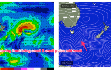
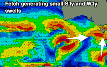
We've got a shift in the wind pattern as a front clips us, bringing cleaner conditions and fun swells for the Mid Coast on the weekend.
Blocking high pressure in the Central Tasman has a ridge up the QLD Coast, with weak pressure gradients across NSW leading to pre-frontal N-NW winds. Not much surf on offer either day.
We should see swells of increasing size, consistency and power through the weekend with good to great winds for the most part.
Large surf today, easing into the weekend ahead of lots of activity mid-late next week.
The high pressure cell develops a healthy trade-wind flow through the Coral Sea into this weekend, generating fun waves from the E/SE from Thurs. It’s quite a persistent pattern, breaking down mid next week.
Cold fronts are passing across the Island and the high pressure will now exert a blocking effect, steering fronts well away from the swell window or ensuring a zonal (W-E) flow through the end of the week and into the weekend.
The high pressure cell develops a healhy trade-wind flow through the Coral Sea into this weekend, generating fun waves from the E. It’s quite a persistent pattern, breaking down mid next week. Small, flukey S swells get even smaller and flukier in the interim, while peaky tradewind swell chugs away.
A mix of S and W/SW swells are due over the coming days with a better pulse of W/SW swell for Sunday.
There might be a couple of better windows opening up around the South West over the coming days. Perth and Mandurah should be fun.
A strong new W/SW groundswell is due late today, with the most size seen tomorrow morning but with strong winds. Follow up swells with better winds look more appealing.