Small mix of fun swells, stronger Sunday

Southern Tasmanian Surf Forecast by Craig Brokensha (issued Wednesday July 12th)
Best Days: Today, Thursday, Friday afternoon, Saturday, Sunday, Monday, Tuesday morning
Features of the Forecast (tl;dr)
- Small S'ly swell this afternoon, easing tomorrow
- Small levels of W/SW swell tomorrow, bottoming out Fri AM ahead of a new pulse Fri PM, holding Sat
- Fresh N/NW-N winds tomorrow, gusty but easing N/NW Fri
- W/NW winds Sat, tending NW later
- Moderate sized W/SW groundswell for Sun, peaking in the PM, easing slowly Mon
- Fresh W/NW tendng lighter N/NW winds Sun, N/NW Mon
- Strong NW tending W/SW winds Tue
Recap
Tricky wind conditions yesterday but with the surf holding 2ft, similar this morning but cleaner.
A fun pulse of S'ly swell is due to maintain 2ft sets this afternoon, easing slowly tomorrow.
This week and weekend (Jul 13 - 16)
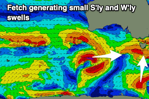
A small, persistent fetch of strong to gale-force S/SW winds should generate a fun pulse of S'ly swell to 2ft this afternoon and tomorrow morning, easing thereafter as less favourable W'ly pulses fill in.
Fresh N/NW-N winds are due tomorrow with gusty but easing N/NW winds on Friday.
Friday morning looks slowest ahead of some new acute W'ly swell into the afternoon, generated by east-southeast tracking but strengthening frontal systems sliding across us.
This will see strong to gale-force W/NW winds generated with a small 1-2ft of swell likely later Friday, holding 2ft Saturday.
We're now looking at a better pulse of moderate sized W/SW groundswell on Sunday, generated by a great, strengthening frontal system moving under the country on Friday evening and Saturday.
A fetch of W'ly gales should produce good 2-3ft sets on Sunday along with W/NW tending N/NW winds into the afternoon as the swell peaks.

The easing trend looks to be slowed into early next week thanks to healthy, trailing frontal activity and this will keep 2ft+ waves hitting Clifton Monday morning with Tuesday likely to persist around 2ft.
Winds look favourable as well, holding out of the N/NW on Monday while Tuesday looks to see strengthening NW winds ahead of a strong W/SW change but we'll review this Friday.
Longer term there's no let up in Southern Ocean frontal activity but it looks to be positioned a bit too far north. More on this Friday.