Winter flat spell continues......
Monday, 17 June 2024
Winter flat spell continues......
Monday, 17 June 2024
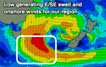
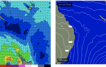
No change to the outlook with low pressure in the Tasman and no swell generating winds for CQ.
No change to the outlook with low pressure in the Tasman and no swell generating winds for CQ.
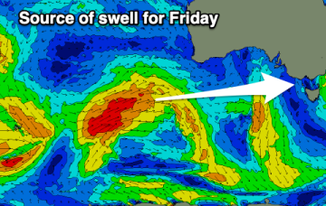
That low is expected to slowly drift and dissipate through the week, maintaining elevated surf through to mid-week with a very slow easing trend in place and a pulse of E/SE swell Thurs.
The coming outlook remains slow and tricky wind wise.
That low is expected to slowly drift and dissipate through the week, maintaining elevated surf through too mid-week with a very slow easing trend in place.
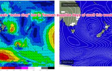
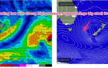
We’ve got a deep low (988 hPa) semi-stationary in the Central Tasman with strong high pressure support south-west of Tasmania and a broad coverage of strong winds to low end gales through the southern Tasman.
The weekend looks tricky with more reliable surf into next week.
We've got plenty of swell due this period but from a funky direction and with tricky winds.
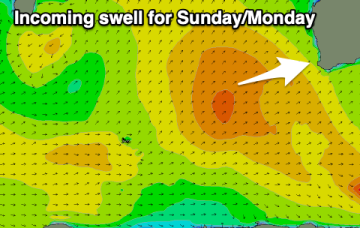
A secondary front pushing into the Tasman coalesces with a deepening low near New Zealand and the system then retrogrades back into the Tasman over an already active sea state delivering powerful E/SE swell before taking up residency in the Central Tasman for a few days next week with a slow, slow easing in big swells expected.
A secondary front pushing into the Tasman coalesces with a deepening low near New Zealand and the system then retrogrades back into the Tasman over an already active sea state delivering powerful S/SE swell before taking up residency in the Central Tasman for a few days next week with a slow, slow easing in big swells expected.
The best swells are behind us with tricky winds and swells for the coming days, possibly better later next week.