Complex period ahead with lots of great waves
Monday, 31 August 2015
Complex period ahead with lots of great waves
Monday, 31 August 2015
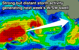
The weather charts are very complex for the entire eastern seaboard.
The weather charts are very complex for the entire eastern seaboard.
Small easing surf with favourable winds for locations east of Melbourne until an onshore change develops Thursday morning. Small fun Surf Coast Saturday and then a touch better next week.
In Northern NSW, the south swell we saw today will ease throughout the morning but a new south swell will build concurrently, arriving across the Mid North Coast early.
West Australian Surf Forecast by Guy Dixon (issued Friday 28th August)
Best Days: Wednesday, Thursday
Recap:
Conditions were great on Thursday with solid 6ft surf across the South West with a few 8ft bombs thrown in for good measure. Light easterly winds were keeping everything in order making for a long day of epic waves. Further north, conditions were clean under light offshore breezes but the surf was lacking in the size department, maxing out at around 1-1.5ft.
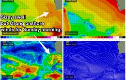
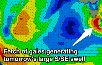
Large building S/SE swell tomorrow afternoon with S'ly winds, secondary SE groundswell pulse for Sunday, solid and easing very slowly through next week as winds improve.
Large stormy S/SE swell tomorrow, with plenty of onshore SE swell Sunday, smaller into Monday and then clean Tuesday but fading.
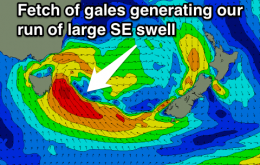
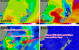
The new S’ly swell from today’s low will be a brief affair, and will ease throughout Saturday.
Average mix of swells and easterly winds tomorrow, cleaner and peaky Sunday, then offshore and good Monday.
Average mix of swells with onshore winds over the weekend, improving Monday with a variable breeze. Fun waves east of Melbourne Tuesday and Wednesday.
Friday’s conditions look pretty good with mainly light variable winds across most regions.