Small surf for a few days; long term looking dynamic from the south

Sydney, Hunter and Illawarra Surf Forecast by Ben Matson (issued Monday 11th January)
Features of the Forecast (tl;dr)
- Small mix of swells all week, though wind affected at times Tues/Wed (mainly a'noons)
- Fun S'ly swell for Sat, easing Sun
- Stronger S'ly groundswell Mon
- Possible large S'ly swell Tues/Wed
Recap: Easing S’ly and SE swells maintained 3ft sets through Saturday, though conditions were a little bumpier than expected across the Sydney region with lingering onshore winds (light offshores held across the Illawarra; the Hunter was expected to be wind affected). Size eased to 2ft on Sunday, and conditions improved with light variable winds everywhere. We’ve seen a further small reduction in swells to 1-2ft this morning, with early light winds and afternoon sea breezes.
This week (Jan 12 - 15)
We’ve got a small week of surf ahead.
Tuesday, Wednesday and Thursday will see small, intermittent levels of NE windswell across the coast, generated by a a stationary fetch lying parallel to the coast. No major size is expected, with wave heights hovering either side of 2ft, slightly bigger on the South Coast near 2-3ft. Early Tuesday morning may be slightly undercooked.
We’ll see periods of NE winds but they’re expected to affect the surf mostly Tuesday (strongest into the afternoon) and then later Wednesday - but following a period of light variable winds early. Thursday should be back to light variable winds and sea breezes as a shallow trough occupies the region. Winds will swing S’ly behind the trough in the afternoon along the South Coast.
Also in the mix all week will be a similar level of trade swell from a broad ridge across the northern Tasman Sea. It will hardly be distinguishable from beneath the NE windswell but it’ll contribute some small peaks to the mix.
Thursday’s southerly change down south will push across Sydney overnight and into Friday morning, and we’ll see initial moderate southerly winds become variable during the day. The trailing fetch won’t have much oomph in it so I’m not expecting a great deal of size from the south to finish the working week. Additionally, our NE swell source will have dried up by this time so we’ll see easing local energy.
However there should be a continuing small undercurrent of peaky trade swell. The combination of all three swell sources might equate to some low quality 2ft sets at exposed beaches but it won’t be anything worthwhile.
This weekend (Jan 16 - 17)
A stronger front will push into the lower Tasman Sea later Friday, providing a more substantial southerly swell for Saturday. South facing beaches are expected to push 3-4ft though they may initially be wind affected. It’ll be a lot smaller at beaches not open to the south. A small level of trade swell should persist at exposed beaches.
The associated southerly flow isn’t expected to last long, so the afternoon’s looking best at this stage with improving conditions, and we’ll see favourable conditions through Sunday with easing southerly swells. Early 2-3ft sets at south facing beaches will be down to 1-2ft by the afternoon and it’ll be smaller elsewhere.
Next week (Jan 18 onwards)
Looks like next week has a few decent south swells lining up, though the first one will be quite acute in origin and direction. It’ll be generated from a cut-off low forming below Western Australia on Thursday, which is then modeled to track along the ice shelf before tracking NE into the Tasman Sea from later Friday through Saturday (see below).
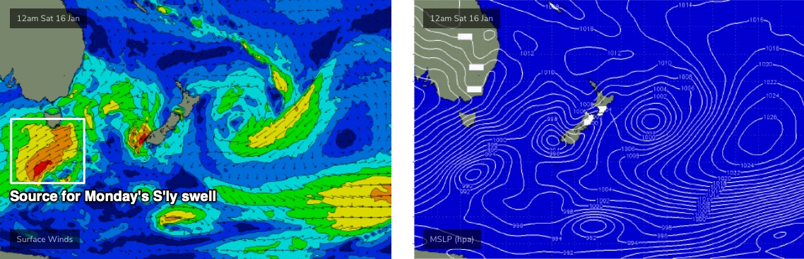
The resulting swell should reach the Far South Coast later Sunday but it probably won’t arrive in Sydney until Monday.
I’m a little cautious on the potential Tasmanian shadowing, but early indications are for very good quality 4-5ft sets at super-reliable south facing beaches on Monday (much smaller elsewhere). Let’s fine tune this in more detail over the coming week.
A more significant cut off low trailing behind has the potential for a major southerly swell during the middle of next week, building Tuesday, peaking Wednesday with sets pushing 6-8ft+. However this is a long time away, so don’t lock in anything just yet.
Either way, there’s a lot of action on the long term charts.
See you Wednesday!
Comments
When are the cyclones coming.......
Cyclones don't mean great swell remember.
But the MJO is forecast to come back around with possible strength in two weeks time, so we'll see.
February- March cyclone swells fire up generally ( quicky pro goldy) time .. hopefully La Niña will produce some cyclone magic this year..
Finally something to look forward to
3-4ft; 4-5ft; 6-8ft set: sounds a good.
need to build up strength before a cyclone swell pounds the coast .