Generally small flukey swells ahead, generally OK conditions

Sydney, Hunter and Illawarra Surf Forecast by Ben Matson (issued Wednesday 17th June)
Best Days: Most days should have fun small peaky waves with good conditions, though Thursday (early morning on the Hunter) and Saturday are at risk of tricky winds.
Recap: We’ve seen persistent E/NE swells offer fun though inconsistent 2ft to nearly 2-3ft waves over the last few days, with clean conditions on Tuesday and this morning under an offshore breeze, ahead of a developing S/SE change that reached Sydney late this morning and is now gusting 25kts. An additional southerly swell has built to around 3ft this afternoon though quality isn’t high under the accompanying breeze.
This week (June 18 - 19)
Our current southerly change will clear to the north overnight, leaving most regions with light variable winds on Thursday. The only exception is the Hunter coast (north from Sydney) which may see early lingering pockets of SE winds, though they will also ease throughout the day.
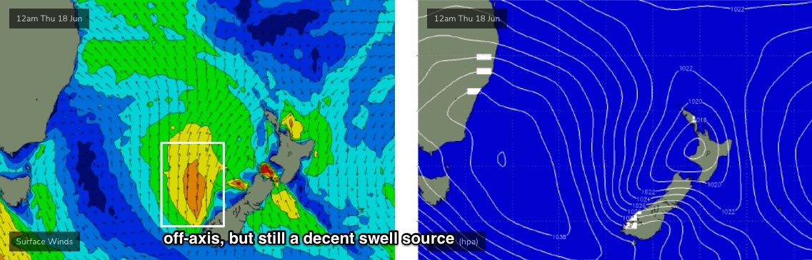
Although the wave models aren’t showing a lot of action, we have a new south swell expected to replace the current S’ly windswell trailing the change, which will ease overnight. This new southerly swell originated from the parent low to the change - when it was underneath Tasmania on Tuesday - though its poor alignment means only south facing beaches will see any size, with occasional 3ft sets at south facing beaches (bigger near 3-4ft+ across the Hunter). Expect long breaks between the sets, and much smaller surf everywhere else from this source.
There’s a chance the swell may not be properly in the water at first light so don’t write it off if wave heights are undersized at dawn. However, a small undercurrent of persistent E/NE swell will keep remaining beaches flush with inconsistent 2ft sets.
Friday will then see easing S’ly tending S/SE swells from 2-3ft at south facing beaches (bigger in the Hunter) along with similar levels of E/NE swell. Light winds will keep conditions clean for most of the day though a late freshening northerly is possible.
Late Friday may also see a small pulse of SE swell, from a front that’s expected to clip the South Island of New Zealand this evening, and then strengthen a S’ly fetch off its West Coast through Thursday (see below). This swell is more likely to peak on Saturday morning, but may provide some late 2-3ft+ sets right on dark Friday.
This weekend (June 20 - 21)
A large cut-off low will dominate the south-eastern corner of the country this weekend, influencing everywhere from the east coast through to the SA/WA border.
It’ll be slow moving, with northerly winds on its eastern flank freshening through Saturday, generating local N/NE windswells that should build to 1-2ft throughout Saturday and then 2ft+ on Sunday morning. Bigger surf is likely south from the Illawarra due to the longer fetch length.
This week’s persistent E/NE swell will slowly easing into the weekend, offering 1-2ft sets at open beaches. The only other swell source is the small SE swell due to arrive late Friday which may provide some 2-3ft+ sets at swell magnets on Saturday morning, but will otherwise fall back to an inconsistent 2ft+ through the day and into Sunday thanks to a poor alignment within our swell window.
Unfortunately, despite a lot of promise in the synoptics over New Zealand from the next few days onwards, it appears that this region won’t properly consolidate its swell generating systems so we’ll probably just see small flukey swells as a result. Note: the swell charts are not picking up this swell at all, so it's not a high confidence event.
Sunday looks better overall with the trough pushing offshore, allowing winds to swing more N/NW, maybe NW.
I’ll take a closer look at all of this on Friday but right now the weekend’s looking a little patchy, and generally small.
Next week (June 22 onwards)
The developing trough off the coast this weekend looks great, except it appears to be aligned much better towards southern locations (i.e. Tasmania’s East Coast). I’ve pulled back my expectations for next week, which is unfortunate as these systems - when they line up properly - often produce some of the best waves for Southern NSW.
As such, early next week is looking at generally small, inconsistent swells from a couple of peripheral sources: E/NE from the trough in the central Tasman Sea and some glancing long period S’ly groundswell from a polar low pushing below Tasmania and New Zealand over the weekend.
The trough is modelled to align a little better inside our swell window through the start of next week (so, there's potential for some flukey SE swells Tues/Wed), but it may not be until the middle of the week where it really starts to kick into gear. Therefore, we may have to deal with two or maybe three days of small surf before wave heights rebuild more convincingly into Thursday and Friday (indeed, the models have a large E/SE swell for next Fri/Sat, but let’s not hold our breath).
See you Friday!