Extended run of quality southerly swell ahead

Sydney, Hunter and Illawarra Surf Forecast by Ben Matson (issued Monday 2nd December)
Best Days: Great waves every day! As long as your beach likes southerly swells.
Recap: Saturday offered fun peaky NE swell around 2-3ft, easing during the day, with early light winds quickly swinging fresh southerly. These winds generated 2-3ft S’ly swells for Sunday across south facing beaches, and moderate southerly breezes eased during the day ahead of another S’ly change in the evening. Wave heights have however eased right back during the day leaving us with small residual surf this morning under a fresh offshore wind.
This week (Dec 3 - 6)
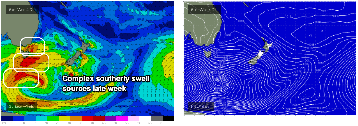
A conveyor belt of fronts crossing the SE corner of the country will generate a series of overlapping southerly swells over the coming week, holding into the weekend.
And the good news is that a locally weak high pressure ridge will maintain light winds and sea breezes up until Friday. So conditions should be nice and clean each day (best in the mornings).
Tuesday will see the first south swell, from SW gales exiting eastern Bass Strait this afternoon. South facing beaches should push into the 2-3ft+ range and the Hunter is likely to see 4ft+ sets at times. However, anywhere not directly exposed to the south will be much smaller.
On Wednesday, we’ll see a stepladder of building southerly swells through the day, probably resulting in an overnight peak. This will originate from a stronger fetch, but less favourably aligned within our swell window, so the coverage may be a little more diverse than Tuesday’s swell. However, we’re looking at 3ft sets at south facing beaches early, building to 4ft throughout the day and it’ll be another foot or two bigger across the Hunter by late Wednesday (smaller earlier, of course, and smaller at beaches not open to the south).
The overnight peak in size will trend down through Thursday though early morning should retain a similar level of size as per late Wednesday.
Friday is interesting. Model guidance suggests smaller surf than the preceding three days, but a distinct swell front is expected to push across the coast overnight Thursday, originating from poorly aligned but otherwise strong winds around the primary low (well south of Tasmania) over the coming days.
I’m hesitant to get too excited about this swell as the even more flukey swell source (see below) will probably restrict the biggest and best waves to just a few locations, but I can’t rule out the chance for occasional 3-5ft sets at south facing beaches at some point early Friday, with bigger 5-6ft+ sets across the Hunter. I do fear that they’ll be the exception rather than the rule though, so expect much smaller surf at most beaches. If we do see any size early morning, it’ll probably ease into the afternoon.
Also on the cards for Friday is a developing onshore breeze thanks to a surface trough to the north, so conditions may become a little bumpy. Let’s take a closer pass in Wednesday’s notes.
This weekend (Dec 7 - 8)
The final phase of the Long Wave Trough will push out from beneath the Tasmanian swell shadow later this week, delivering a final solid south swell for the weekend. At this stage core winds don’t look like they’ll be exceptionally strong, though their extended duration within our swell window means we’ll see strong S’ly swell all weekend.
At this stage we should see a steady upwards trend into the 4-5ft range at south facing beaches, holding early Sunday before easing during the day. Expect larger sets in the 6ft+ range across the Hunter, but much smaller surf at beaches not properly exposed to the south.
Early light winds will precede moderate afternoon SE breezes in the afternoon, in association with the trough to the north (on Saturday). Light winds and general NE sea breezes are expected on Sunday as we fall under the influence of a high pressure ridge.
So all in all, a good weekend of solid south swell.
Next week (Dec 9 onwards)
Nothing to get excited about next week at this stage, with small local swells and variable conditions.
Comments
Heavy seeing the areas affected by the fire down in the deep South :(