Small swells from the south, and a brief flush from the north-east

Sydney, Hunter and Illawarra Surf Forecast by Ben Matson (issued Wednesday 20th November)
Best Days: Thurs: small S'ly swell at south swell magnets, early light winds. Fri: peaky NE swell, NW winds tending gusty S'ly early, then abating. Southern ends fun all day, though the swell will ease into the a'noon.
Recap: S’ly swells have pulsed intermittently over the last few days, around 2-3ft across Sydney’s south facing beaches and up to 3-4ft across the Hunter. Tuesday morning saw light winds and clean conditions ahead of freshening NE sea breezes preceding a S’ly change that reached Sydney after dinner. Light S’ly tending E/SE winds have padded out today.
This week (Nov 19 - 22)
Small persistent S’ly swell will continue for the next few days, originating from the same broad frontal pattern that’s occupied the Southern Ocean south of Tasmania over the last week or so.
Although confidence isn’t especially high because of the flukey swells source and acute southerly direction, we should see size fluctuate between 2ft and almost 3ft range at south facing beaches, slightly bigger in the Hunter but much smaller elsewhere.
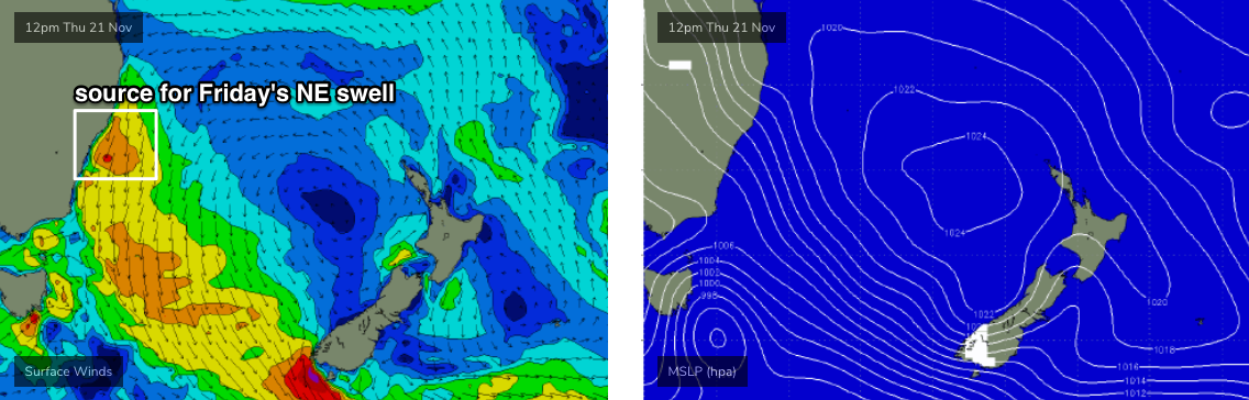
Thursday morning will be clean with early offshore winds, ahead of freshening NE breezes into the afternoon that’ll become quite gusty later on, generating some local windswell (see below).
In fact, the models have perked up this fetch since Monday and we’re looking at some nice waves on Friday as an advancing trough disrupts the NE airstream overnight, swinging the breeze to the NW ahead of a S’ly change that’ll nose into Wollongong just before dawn and Sydney an hour or two later.
Winds will be gusty at first, but should ease back throughout the day and there’ll be plenty of punchy though abating NE swell on offer, from 3-4ft down to 2-3ft throughout the day. Southern ends should have some nice waves.
The S’ly change will kick up some local windswell throughout the day too, though there won’t be much quality in it.
This weekend (Nov 18 - 19)
Friday’s southerly swell - and any local windswell it creates - will be almost completely gone by Saturday morning. We may see some small lingering lines from distant activity in the Southern Ocean though no major size is expected.
The source of Friday’s NE swell will have retreated back through the window thanks the approaching change, but the fetch will remain active off the Mid North Coast into Saturday, and although poorly aligned, should maintain 1-2ft of NE swell for exposed beaches.
Local winds look generally light and variable on Saturday under the influence of a broad trough, but it’s expected to slide to the north into Sunday, freshening S/SE winds across the region and delivering very average conditions to most beaches for a period in the morning (though conditions should improve in the afternoon as winds throttle back, especially south from Wollongong).
The southern flank of the trough may generate some short range windswell for Sunday but current indications are that it won’t be very high in quality.
Next week (Nov 20 onwards)
Freshening NE winds Monday will generate a small NE swell that’ll peak early Tuesday, though nothing major is expected at the stage.
We’ll also see some small S’ly swell from a poorly aligned front under Tasmania over the weekend. Again, surf size will be small from this source.
General troughiness will remain a feature for the long term outlook so although there are no significant swells showing on the charts, there’ll be plenty of ingredients in the western Tasman Sea waiting to be activated.
Hopefully Friday’s update will have a little more info on some long term swell events to look forward to.