Stacks of swell ahead; just not from the source you think

Sydney, Hunter and Illawarra Surf Forecast by Ben Matson (issued Wednesday 20th February)
Best Days: Stacks of swell from Friday onwards, but poor winds until Tuesday next week, which is the first proper day we'll probably see good waves. And really, don't expect a great deal of swell from TC Oma either. It'll be flukey at best (though, worth sniffing around those NE swell magnets with S/SE wind protection, on Fri/Sat/Sun).
Recap: A southerly change pushed through on Tuesday morning, bumping up most beaches and lifting southerly windswells to 2-3ft throughout the day. We’ve seen this size range persist today, with mixed conditions - fresh southerlies in some regions but light south-west winds in others. A small E/NE swell is also in the mix.
This week and weekend (Feb 21 onwards)
Today’s Forecaster Notes are brought to you by Rip Curl
A high in the Bight and the approaching Tropical Cyclone Oma in the Coral Sea will strengthen a ridge across Southern NSW into Thursday, freshening S/SE winds across most locations and creating average to poor surf quality.
We’ll see building swells from a couple of southern sources: poorly aligned fronts south of Tasmania will kick up some southerly groundswell, the ridge itself will generate a building windswell - both biggest Friday, reaching 2-3ft north from from Sydney to the Hunter but smaller south from Sydney, and exclusive to south friendly beaches.
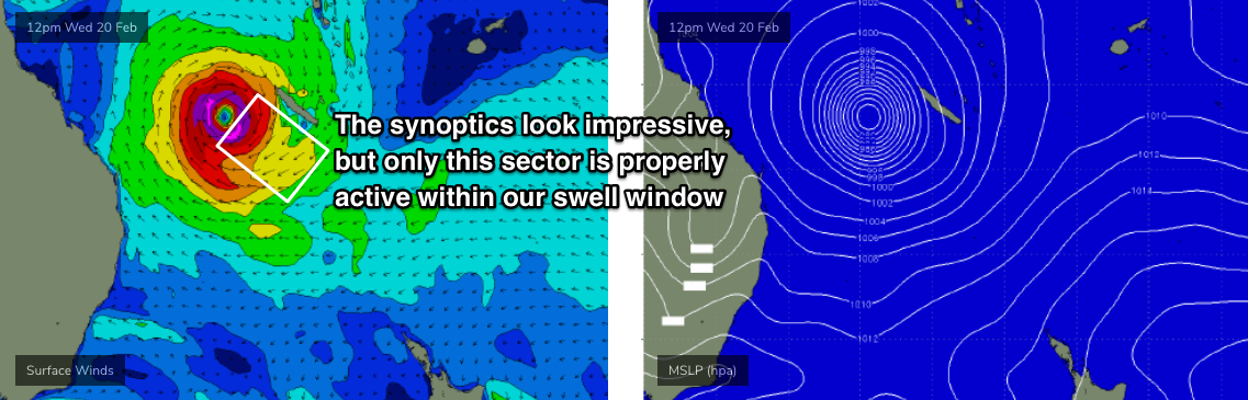
But, TC Oma is the only weather system of interest to us. At the moment it’s Category 2 and expected to maintain strength enroute to the waters off SE Qld. The most impressive fetch around its core is aimed into locations north from Byron Bay, so we’ll see smaller surf with increasing southerly latitude. And, Southern NSW being so much further to the south, is expected to pick up only a small percentage of size.
But, even a small percentage of an extraordinarily large swell (by Qld standards) could end up being quite worthwhile for savvy surfers in the southern part of the state. We’re yet to see any signs of new energy in Northern NSW at the moment, so - despite model guidance maintaining NE swell from today into tomorrow (keeping in mind the Chesterfield Islands blocking reference in Monday’s notes) - I think we should maintain skepticism that there’ll be much in the water on Thursday. Late afternoon may see a small pulse if we’re lucky, but I’ll update more on this in the comments below tomorrow morning as we assess the observations further north - which is ‘upstream’ from Northern NSW and a convenient heads up on possible arrival times further south.
Friday is where we should start to see a more appreciable increase in NE swell across the region. Most of this increase will be sourced from a relatively short though reasonably broad fetch on the eastern flank of TC Oma today (see below), it’ll be quite a steep angle though so expect a wide range in wave heights, even amongst beaches with good NE exposure. Translated, this means: don’t get your hopes up, as it’ll be a fickle swell event, especially if there’s even partial NE sheltering for your coast (hello Hunter region!).
How big? The S’ly swell combo will probably be dominant at more beaches, but a handful of reliable NE swell magnets should see 2-3ft surf during the morning, possibly increasing to 3-4ft throughout the day. But it’s a low confidence even so don’t rack up any highway miles. Local winds will confine the only rideable options to protected southern corners anyway.
Looking beyond the weekend, and whilst TC Oma is expected to go ham off the SE Qld coast (50-70kt core fetch just off the coast with massive surf for exposed coasts north from Byron), most of the fetch will be aimed into the Coral Sea. Only a very small region of winds will be positioned within our swell window, so I’m going to be extremely cautious on the prospects of swell from this cyclone.
Additionally, as the cyclone moves closer to the coast, the swell direction (within our swell window) will creep a little more north of north-east, which becomes even steeper and thus even more flukey for Southern NSW.
So, we could see occasional 3-4ft sets from the NE throughout the weekend, though I fear the vast majority of locations will dip out due to coastal shadowing, or unfavaourable bathymetry. Remember, as discussed in previous notes: we don't see NE groundswell events very often, so we're not as well tuned into which beaches/reefs pick up the most size from swells with these characteristics.
Elsewhere, the supporting ridge to the south, lying across NSW, will generate plenty of SE swell for Northern NSW, and we’ll see a smaller spread of E’ly swell in our region, building to 3-4ft or 3-5ft throughout the weekend.
As it is, the most dominant swell source for the weekend will be a strong polar front expected to rocket into the Southern Tasman Sea, restrengthening the ridge and generating 4-6ft S’ly swell at south facing beaches , peaking Sunday.
However, the accompanying fresh to strong S/SE winds won’t do many beaches any favours.
Long term, and I can’t see TC Oma spinning up in our favour to any great degree, but the weekend’s strong frontal system will become a good source of surf for the long term: after Sunday’s south swell, we’ll see a reinforcing E/SE swell (3-5ft) early next week from a ridge through the Tasman Sea, and then a smaller SE swell next Tues/Wed from a latter reincarnation from the low as it takes up residence off the SW tip of New Zealand’s South Island on Sunday.
So, there stacks of waves ahead, just not from the tropical source you might have thought would be responsible, given all of of the discussion elsewhere.
And unfortunately, poor in quality for the most part. Light winds and workable conditions are not really likely until later Monday, more likely Tuesday next week (fortunately, there’ll be some good SE swell in the water by this time).
See you Friday!
Comments
Hey Ben. Ever seen the models being so divergent in such a short time frame?
They're not that divergent, considering (i.e. this happens frequently).
It's only much more noticeable because it's a Cat 2 cyclone sitting close to the Qld coast - so the ramifactions (i.e. difference in surf potential) is somewhat exaggerated.
Got ya, interesting twists and turns that’s for sure. Love the coverage, the comments on the QLD forecast put these ones to shame.
I got a mate living in Byron, he currently living in noosa in his van since last night! Eating, surfing,stretching,sleeping and throttling cones will be his life til this cyclone pisses off! Some people have their priorities right!
Hey Ben, I am wondering about the area that falls between your two forecast notes. It seems to me like you are saying that South Queensland and Northern NSW will be maxed out while areas south of the Hunter will be fluky and mid-sized. What's in store for the Mid-North Coast points? Something more manageable?
Harry
Covered in SE Qld/Northern NSW forecaster notes.
https://www.swellnet.com/reports/forecaster-notes/south-east-queensland-...
Seen the WAMS for next weekend?!
Jesus, any chance of that actually happening?!
It appeared last night. Hasn't changed through the subsequent updates.
Do I dare to believe?
I’m up in NSW next weekend and have been refreshing the forecast more than I should. A day or two ago it was only forecast to be 1ft!
Can go either way - models are split
Either its coming for you Stu - and you are gonna need the big board
or Huey really doesn't like Townsville!
Thanks Ben, great report very detailed as usual.
Should Geoff get his herpes removed? Would hate for his diseases not to be treated again based on inaccurate long term forecasts.
Looks like anywhere south of Sydney will remain in the doldrums and not going to be worth the petrol money. Bathymetry for this event just wont suit and the south swell will not be enough for any where decent with the wind.
Anyway please post up more pics of the Newcastle cam. They are great.
Keep it up.
Sorry guys, running late - had a 90 min power outage on the Tweed today which totally screwed my afternoon (not like we're busy today...). Will have the forecast up around 6pm.
Oma heading south then north what a teeeeez