Great waves Tuesday morning, plenty more swell to come, large from the south Friday PM

Sydney, Hunter and Illawarra Surf Forecast by Craig Brokensha (issued Monday 14th May)
Best Days: Tuesday morning, Thursday, Friday, Saturday morning, Sunday and Monday mornings
Recap
The weekend played out pretty much to plan with tiny to flat conditions Saturday morning, with a steady increase in size observed from late morning/midday with step-ladder sets pushing quickly from 2-3ft to 3-4ft to 5ft+ through the afternoon.
Late in the day south magnets saw 6ft+ sets and with favourable W/SW offshore winds across most locations.

This pulse eased back through yesterday, with OK conditions early, average through the day. A late new pulse of S/SE swell provided fun waves for the late session, while this morning we saw good large sets from the S/SE with SW-S/SW winds.
South magnets were hanging in at 6ft, but a stronger SE pulse filled in through the mid-late morning, offering solid sets at more open beaches.
Looking at the transition of the Tasman Low over the weekend, and our fresh SE pulse has been pulled forward a little to later today and this evening, but more on this below.
Today’s Forecaster Notes are brought to you by Rip Curl
This week and weekend (May 15 – 20)
These notes will be brief as Ben’s on holidays.
 Yesterday a broad fetch of strong S/SE winds were positioned in our southern and south-eastern swell windows, with a slight intensification of SE gales projected towards our region through the afternoon and evening.
This has produced a stronger SE pulse that should kick near dark today and peak overnight likely to 6ft to occasionally 8ft, easing back through tomorrow from 4-6ft early and then further from the 3-4ft range Wednesday morning. The Hunter will see larger sets through the morning.
Conditions tomorrow morning are still looking great with an W/SW offshore, but a weak front will push up from the south through the day bringing a S/SE change early afternoon and a fresh pulse of S/SE swell for Wednesday afternoon to 3ft+ across south facing beaches, mixed in with the easing SE swell.
With this, Wednesday mornings winds are average and fresh from the S/SW-S through the morning and S/SE into the afternoon.
Both the SE and S/SE swells should ease through Thursday, but a new S'ly groundswell is due across south magnets, produce by the parent low linked to the weak front pushing through Tuesday.
A polar fetch of gale to severe-gale W/SW winds south-southwest of Tassie this afternoon and early tomorrow morning.
We should see south magnets continuing around 3-4ft Thursday morning with a W/NW offshore (variable into the afternoon), easing off into the afternoon and smaller 2ft Friday morning.
This low point will only be temporary, as we're expected to see a large and powerful long-period S'ly groundswell building across south facing beaches through the day.
 The large groundswell is being under forecast by the wave models, with it being generated by a very impressive polar low over the coming days.
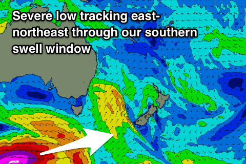
We'll see this polar low form south of the country, generating a fetch of severe-gale to storm-force W'ly winds in our far southern swell window.
The low will project favourably east-northeast up towards New Zealand while weakening slightly Wednesday and then stalling slightly Thursday.
The long-period fore-runners upwards of 20s are due to arrive Friday morning, with the bulk of the swell pushing in through the mid-late afternoon, kicking to 4-6ft across south facing beaches by dark.
Now these long-period S'ly groundswells always do funky things and focus into some places and not into others, to expect to do a bit of driving if trying to maximise the swell potential off this system.
Winds are good Friday morning with a straight W'ly offshore, but a weak S'ly change is due into the afternoon as the S'ly groundswell really muscles in.
Saturday morning will be clean again with a light W/SW offshore as the S'ly groundswell eases from the 3-4ft range (larger across the Hunter), slowed by the stalling nature of the low south-west of New Zealand.
An afternoon S'ly change will likely bring some new S'ly windswell Sunday and larger groundswell Monday with morning SW winds, but more on this Wednesday.
Comments
This guy been hanging out with Shane Ackerman?
That's classic. The bombie was firing yesterday during that arvo pulse.
Pretty bloddy good today!
And check the second story from Matt Dunsmore: https://www.instagram.com/stories/mattdunsmore_/