Easing swells throughout the period, with tricky winds

Sydney, Hunter and Illawarra Surf Forecast by Ben Matson (issued Friday 15th December)
Best Days: No great days in general. Saturday for the most size of leftover E/NE swell and easing NE windswell. Tricky winds though.
Recap: A mix of NE windswell and E/NE groundswell have provided plenty of waves over the last few days. Freshening N/NE winds on Thursday swung gusty S’ly in the early hours of this morning, but have eased back this afternoon to become light and variable. Sets have been up to 3ft+ at exposed beaches.
Today’s Forecaster Notes are brought to you by Rip Curl
This weekend (Dec 16th - 17th)
We’re inside 24 hours from the weekend and the wind outlook is no less tricky than what was discussed on Monday and Wednesday.
A slow moving trough will deliver variable conditions right along the coast both days, though broadly speaking we’re looking at N/NE winds in the north (i.e. Illawarra to the Hunter), with S’ly winds in the Far South. Between the two we’ll see variable periods, though the S'ly flow will push up the coast and may briefly clip the Sydney region overnight Saturday.
If anything, the northerly flow will retreat to the north over the weekend (as the southerly flow advances northwards), but the northerly presence off the Central/Hunter/Mid North Coasts will maintain small NE swells across our beaches through the weekend - smaller than today but still fun across open beaches.
As for size, wave heights around the 2ft+ mark at NE facing beaches seems reasonable at this point in time for Saturday, as there’ll still be some leftover E/NE groundswell in the mix. Expect smaller surf at south facing beaches, and the sets will be very inconsistent.
Sunday may be a shade smaller as the E/NE swell fades but the NE windswell maintains. Expect very infrequent sets too.
Next week (Dec 18th onwards)
Freshening N/NE winds across Southern NSW the first half of next week will slowly build NE windswells that are expected to peak on Wednesday around 3ft. Expect smaller surf prior to then, with generally average conditions under a dominant NE airstream.
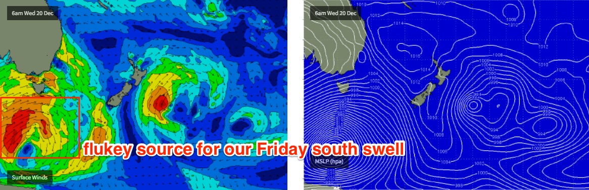
Whilst the weather charts still remain promising in all of our basins, there is still no sign of any major swell generating system for Southern NSW. Probably the most promising is a deep cut off low forming west of Tasmania early in the week.
It’ll eventually slip below Tasmania around Wednesday and briefly enter our acute south swell window, setting up a series of south swells that’ll build slowly through Thursday (2-3ft sets south facing beaches) ahead of a poorly aligned but long period S’ly groundswell arriving Friday afternoon and Saturday that could reach 3-4ft at reliable south swell magnets.
Let’s take a closer look on Monday.
Comments
Good time to surf....NZ
Hmm, BOM are forecasting a 1.5-2m NE swell for tomorrow. Not quite sure where they're getting this from.
Hmm are we heading into a era of clashing forcasting? surfer VS main stream uni guy weather man..
I'm going to put my eggs In the surfer forcasting (weather including)
As I don't think anyone can understand weather/waves etc etc to the finer detail as us!
We can see Our forecast painted on the face of a wave a understaning that only comes if your a good compident surfer..
Where you normal everyday person can just see rain wind and clouds etc..
But I'm hoping your wrong tomorrow Ben so can have a surf.
Gonna be a little late again with the notes today, apologies.