Aim for the end of the week with a NE and E/NE swell

Sydney, Hunter and Illawarra Surf Forecast by Ben Matson (issued Monday 11th December)
Best Days: Thurs: peaky NE swell with easing N'ly winds. Fri: tricky winds (tho' prob light/var) and a mix of easing NE windswell and inconsistent building E/NE groundswell. Sat: easing mix of swells with light winds.
Recap: The weekend delivered fun waves with easing E/NE swells Saturday and a small mix of southerly swells on Sunday. Conditions were clean with early light winds, though Saturday still saw bumpy conditions through the Hunter thanks to a lingering SE breeze from Friday night’s change. The afternoons delivered freshening sea breezes. Today has seen a low point in swell with small weak beachies and early light winds ahead of the afternoon sea breeze.
Today’s Forecaster Notes are brought to you by Rip Curl
This week (Dec 12th - 15th)
We’ve had a downgrade for our upcoming south swell.
Today is already slightly under budget, and this is largely due to the weekend’s source fetch being right on the periphery of our swell window, resulting in flukey, intermittent energy glancing the coast at best.
This trend will continue through Tuesday ahead of a small pulse on Wednesday, bigger than the preceding days but smaller than Friday’s notes were anticipating. This swell was generated by the stalled parent low south of the Tasman Sea last night and today. However it’s not quite as well lined up as Friday’s model runs suggested, so the swell will again just clip the Southern NSW coast. Reliable south swell magnets may pick up some stray 2ft, almost 2-3ft sets (more likely the Hunter coast than anywhere else), but they’ll be far and few between. The South Coast may see a late Tuesday arrival; everywhere else will see this swell early Wednesday. But most other beaches will remain tiny.
Also influencing Wednesday’s surf potential - as discussed on Friday - is a local freshening NE breeze. In fact, it’s expected to reach 20-30kts into the afternoon and will thus generate a local windswell that’s likely to override the small, intermittent south swell, with sets pushing 2-3ft at NE swell magnets by late afternoon/early evening (smaller prior to this).
A weak trough will cross the coast during Thursday, causing the N/NE wind to ease throughout the morning and tend more N’ly. The upside is that the NE swell should reach a peak early in the day (3ft+ sets at NE swell magnets); the downside is the conditions won’t clean up much, if at all - or perhaps not until the afternoon once the trough starts to influence the coast.
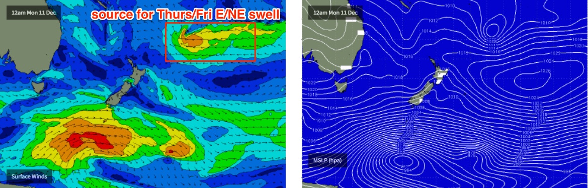
At the same time, a long range E/NE swell is expected to make landfall, generated by a deepening E’ly dip located N/NE of New Zealand. This system looks very impressive on the charts, but it is a long way from the mainland so the swell it generates will be extremely inconsistent. The models are slightly undercalling this swell (2ft) but I reckon we'll see some fun waves despite their infrequent nature.
Expect building size from this source through Thursday ahead of a peak in size on Friday with very occasional 3ft+ sets (keep in mind that this swell will be even more inconsistent than anything seen in recent weeks). Also in the mix will be easing NE windswell from Thursday.
Friday’s probably looking to deliver the best day of the working week, as we’ll see variable winds associated with Thursday’s trough, which is likely to stall off the coast somewhere. If anything we’ll probably see a S/SW flow, but there’ll be regions with little to no wind at all. I’ll try to pinpoint them in Wednesday’s update.
This weekend (Dec 16th - 17th)
Looks like a weird weekend of wind, weather and surf ahead.
The stalled trough off the coast is modelled to hang around, which means the wind outlook is very uncertain.
Friday’s E/NE swell will still be with us but we’ll be on the backside of the event, which means decreasing consistency (!) and easing size.
A small N’ly fetch north of the coastal trough and a SE fetch south of the trough may generate small peaky waves for the Sydney region but it’s too early to pin down specifics.
Let’s take a closer look on Wednesday.
Next week (Dec 18th onwards)
Nothing specific to pinpoint down in the longer term outlook at this stage, unfortunately. All of our swell windows are showing signs of activity, from the tropics in the South Pacific and the Coral Sea, plus the Southern Ocean and a couple of regions through the Tasman Sea.
Either way, it looking like the lead into Christmas will be flush with swell, but we’ll have to leave it a few more days to nail things down.
Comments
cold water on thu/fri again?
Depends how shallow the current layer is. The NE spell will be only a few days long (relative to recent episodes) so it's a little less certain. Though it may not take much to quickly overturn a shallow surface layer.
I reckon yep we're in for another upwelling event.
Could even feel some cold pools down the South Coast Sunday afternoon with the NE'ly.
i'm still feeling cold from that sunday 2 weeks ago