Average weekend waves; complex next week with a series of new swells

Sydney, Hunter and Illawarra Surf Forecast by Ben Matson (issued Friday 27th October)
Best Days: Sat: early window of light winds and a peaky SE swell. Sun: light morning winds and a small, easing SE swell. Wed: winds swinging offshore with a punchy though lumpy short range S'ly swell. Thurs: large S'ly swell though with dicey winds. Fri: rapidly easing S'ly but peaking E/NE swell with light winds. Sat: fun E/NE swell wth light winds.
Recap: Wave heights were very small Thursday, and freshening southerly winds during the day have persisted into today, with wave heights slowly building from the SE; early sets were around 2ft and now they’re pushing 2-3ft. Quality is however pretty poor.
This weekend (Oct 23 - Oct 24)
No change to the weekend forecast.
We’re still yet to see this new SE swell reach a peak. Winds will reach maximum strength in the central Tasman Sea this afternoon, which means Saturday - probably late morning or lunchtime - will see the most size with peaky sets in the 3ft+ range at reliable swell magnets.
Fortunately, the Tasman Low will have moved sufficiently east to allow winds to swing light offshore in the morning. There’ll still be some surface wobble through the lineup at dawn, but it’ll get better as the morning progresses.
But, don’t leave it too long as NE sea breezes are expected after lunch.
Sunday morning will see the swell fading steadily, early 2ft to maybe 2-3ft sets at reliable swell magnets if we’re lucky, but barely smaller elsewhere, and losing a foot or so throughout the day. Winds should be light and variable in the morning but NE sea breezes are likely into the afternoon.
Next week (Oct 25 onwards)
Monday looks pretty small and uninteresting.
The weekend’s SE swell will be all but gone and a minor NE windswell generated by a brief fetch off the Mid North Coast Sunday night probably won’t have very much size. An afternoon S’ly change is expected across the South Coast, reaching Sydney around dinnertime.
The rest of the week looks very complex with a couple of swell sources on the cards.
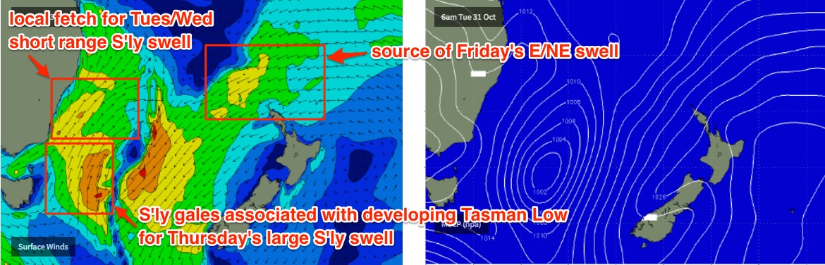
Initially, Tuesday appears to be a write-off with strong S/SW winds in the wake of Monday’s cold front, and a rapidly building though low quality windswell at south friendly beaches. South swell magnets should see 4-5ft sets (maybe a tad undersized early) but locations offering shelter from the wind will be very small. I can’t see there being anything of interest.
At the same time, a new Tasman Low is expected to develop, though much further south than Wednesday’s model guidance indicated - they’re now suggesting it’ll spin up at the tail end of the fetch related to Monday’s change, somewhere east of Tasmania.
This will have two flow on effects - (1) it’ll maintain strong S/SW winds parallel to the Southern NSW coast on Tuesday (keeping short range south swell very active through Wednesday) and (2) the low will move slowly to the north, working on the pre-existing active sea state and generating a larger southerly swell for Thursday.
Interestingly, as the low approaches the coast on Wednesday, local winds are likely to veer W/SW ahead of it, cleaning up conditions across the Sydney, Hunter and Illawarra coasts. Early indications are for continuing 4-5ft sets at south facing beaches, and smaller waves elsewhere.
The new groundswell from the Tasman Low is expected into the South Coast very late Wednesday afternoon (along with a S/SW wind change) and it should reach Sydney in the early evening, providing strong waves through Thursday that should push well in excess of 6ft at south facing beaches, maybe up to 6-8ft+ at offshore bombies and across exposed Hunter breaks. Beaches with less southerly swell will however be much smaller.
Winds do look a little tricky though, likely to be fresh from the SW early, then gusty S/SW during the day. This will relegate the best waves to sheltered corners and points.
As the low clears to the east, surf size and local winds will rapidly abate into Friday.
But that’s not everything!
As the S'ly swell(s) begin to ease, a mid-range E/NE swell will be pushing into the coast, generated by a stationary trough SE of New Caledonia and a slow moving high pressure system east of New Zealand that are about to join forces in the South Pacific over the coming days.
A broad belt of E’ly winds north of New Zealand will develop from this weekend onwards, and although not terribly sizeable, it’ll kick up a long lived swell event that’ll probably start to arrive sometime on Wednesday and then peak later Friday or maybe early Saturday. Set waves should manage 3ft+ from this source at its peak, sometime around the end of the week (I'll firm up the timing on Monday).
Maximum surf size will probably originate from a small embedded low at the head of the fetch - just northwest of New Zealand’s North Island later Tuesday - but the broad trailing fetch behind will linger much longer, and should supply small background E/NE swell through next weekend and the early part of the following week.
Have a great weekend, see you Monday!
Comments
Good ASCAT pass this morning, on target for fun 3ft+ surf tomorrow.
Wow, already some major model revisions since today's forecast (done earlier than usual with 12Z data). 18Z update has tightened the Tasman Low, sped it up and pushed it closer to the coast - which wuld result in an earlier swell, marginally bigger than estimated above. But still a long way to go and likely to change many more times over the coming days.
Nice options this morning at Manly:
The sea breeze is now up across the Northern Beaches but it's still clean across Cronulla, and there's a few slabs at the Island.