Small surf initially, then solid and windy from the south

Sydney, Hunter and Illawarra Surf Forecast by Ben Matson (issued Monday 27th March)
Best Days: No great days. Maybe Thurs morning with an early NE windswell and a temporary period of light winds.
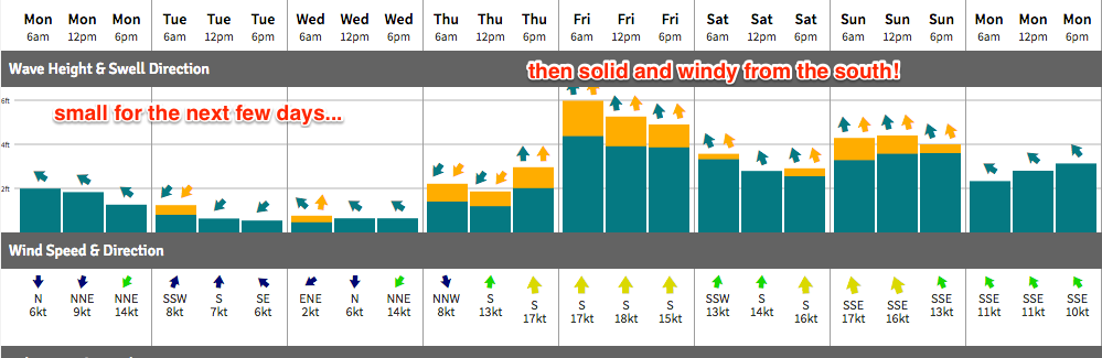
Recap: The weekend delivered pumping SE swell form a Tasman Low, with sets around 4ft on Saturday easing slowly through Sunday and further into today. Winds were generally light so conditions were clean.
This week (Mar 28th - 31st)
Note: Forecaster Notes will be brief this week because Craig’s on leave.
NE winds this afternoon may generate a minor NE windswell for Tuesday but no great size or strength is expected.
Very small condition will therefore persist through Tuesday and Wednesday. SE Qld is currently seeing some cyclone swell from TC Debbie but this system was located outside of Southern NSW's swell window, so we won't see any action down here.
A broader local freshening NE flow on Wednesday should whip up a peaky NE windswell for Thursday morning (2ft, maybe 2-3ft at a handful of reliable NE swell magnets south of the Cenny Coast) but it’ll peak early and trend down during the day. A strong southerly change will rocket into the South Coast early morning and Sydney before lunch, with a building S’ly windfall late in the day that could reach 4ft at south swell magnets.
This change is expected to stall off the Northern NSW coast and should form a small Tasman Low east of the Hunter later Thursday, driving southerly gales into Southern NSW on Friday and further building wave heights locally, probably around 4-6ft at south facing beaches though of dubious quality owing to the gusty local airstream. Expect smaller surf south from the Illawarra; this fetch will be mainly concentrated up into the Sydney/Hunter coasts.
As such protected corners will be your only option to finish the week.
This weekend (Apr 1 - 2)
Saturday should see easing surf from the Tasman Low with moderating SW tending S’ly winds. South facing beaches around the 3-4ft mark (smaller later) and no great surf in general though there’ll be small workable options if you're keen.
On Sunday, a very long period (19-20+ second) S’ly groundswell - originating from a sneaky polar off the Ice Shelf south of SA this Wed and Thurs - is expected to make landfall across the Sydney region. It should provide occasional 3-4ft sets at reliable south swell magnets by the late afternoon (more so into Monday). Expect smaller residual swell early morning.
Locally, the synoptic chart is tricky for Sunday with a divergent array of solutions from the models. However broadly speaking we will have a strengthening high in the Bight and a trough or possible low off SE Qld and Northern NSW, which should extend E’ly winds into most parts of the East Coast and could build some local swell across the region (models are a little optimistic right now). It’s still early days though so check back on Wednesday.
Next week (Apr 3 onwards)
Very tricky long range outlook due to the suggestion for a couple of complex troughs and or low pressure systems in the southwestern Coral Sea, close to the mainland. As such next week looks very active for many part of the East Coast.
We’ll also see some lingering long period S’ly swell on Monday from the sneaky polar low south of SA this week. But only at reliable south swell magnets.
Comments
Looks like Debbie does a comeback next week.