Flag the weekend; Monday looks better for a fun south swell

Sydney, Hunter and Illawarra Surf Forecast by Ben Matson (issued Friday 11th August)
Best Days: Monday: fun S'ly swell with good winds.
Recap: On Thursday, the early morning had tiny leftover surf that essentially became flat throughout the day as the energy subsided further. Early this morning a small S’ly swell pushed up into the coast, and is producing 2-3ft sets at south facing beaches. A small E/SE swell is also in the mix at remaining beaches. Winds were light offshore this morning, so conditions were clean, but a weak sea breeze has just developed. Winds should go back to the NW later this afternoon and freshen.
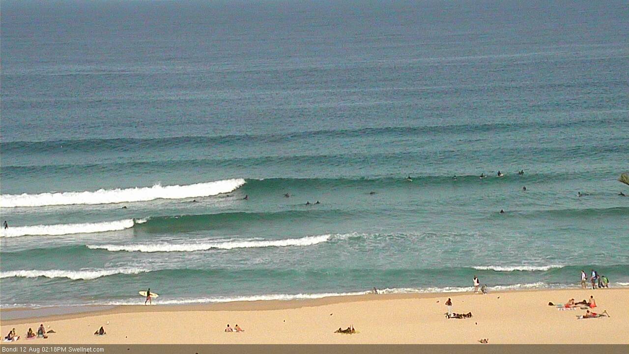
Fun afternoon lines outta the south at Bondi. Watch it live here.
This weekend (Sat 13th - Sun 14th August)
The weekend looks very ordinary for surfers.
Today’s combo of S’ly and E/SE swells are expected to ease overnight, and bottom right out at some point during Saturday. We may see some lingering lines early morning at exposed south swell magnets, but I’m doubtful that we’ll see much more than 1.5ft (maybe a shade bigger in the Hunter, but smaller at beaches not open to the south) and by the afternoon it’ll be even close to flat.
Surface conditions will be nice though with light offshore winds.
A weak front passing through the lower Tasman Sea on Saturday morning has been wound back a touch in the latest model guidance (nooo!) so I have correspondingly pulled back the size and arrival time of the minor pulse expected from this source on Sunday. We’re looking at tiny to flat conditions to start to the day, building across south facing beaches into the afternoon with sets pushing 1-2ft.
The best surfcam to watch this advancing swell will be Bondi (click here).
However, unlike the south swell we saw today it’s expected to have very little strength or structure. And early W/SW winds will probably swing to a moderate to fresh southerly during the day, bumping up those beaches actually raking in any energy (most beaches will remain tiny to flat).
A better south swell is due overnight and it’s plausible that the Far South Coast may see the leading edge push through late afternoon, but anywhere north of about Ulladulla is unlikely to see any favourable surf this weekend. Sorry!
Next week (Mon 15th August onwards)
A strong front pushing underneath Tasmania overnight Saturday and into Sunday morning is expected to generate a decent flush of south swell for Monday morning. In fact, this swell will probably peak sometime early-mid morning, and then slowly trend downwards throughout the afternoon, so you’ll have to aim for a dawn patrol to make the most of the size.
The best surfcams to watch this swell will be Bondi (click here), Cronulla Beaches (click here) and Newcastle (click here).
South facing beaches will as per usual pick up the most size, with set waves somewhere in the 3ft+ range. Unfortunately, the atmospheric models have continued to downgrade it over the last few runs - trending it more zonal in alignment, and also pushing it more quickly through the swell window than is ideal. Our surf forecast model isn’t picking up this energy very well (estimating just 2ft surf), but I think we’ll see some decent waves for the morning session.
Beaches not open to the south will be smaller in size (1-2ft) but the northern Hunter should see a few bigger sets and it’ll be clean with offshore winds.
Tuesday looks really interesting. For the most part, our swell window will have gone quiet from late Sunday through Monday, so ordinarily it would be expected that we’d see very little surf across the region as Monday's energy is expected to mainly be a one-day affair.
However, a deep mid-latitude low is expected to rapidly intensity W/SW of Tasmania on Sunday, with surface wind speeds approaching 60-70kts. This system will generally be positioned outside of our swell window however the sheer size and strength of the supporting fetch can’t be discounted. And we also can’t ignore the peak swell periods resulting from this fetch, which will probably reach upwards of 20 seconds.
This swell is expected to glance the Southern NSW coastline on Tuesday. I suspect that most beaches will largely miss out from this event however reliable south swell magnets (I’m looking at you, Newcastle!) could do reasonably well from this. I’ll be better positioned to make a call on Monday, but for now I’ll ballpark very inconsistent 2-3ft sets at south facing beaches across the Sydney region, and up to 3-4ft across the northern Hunter.
Everywhere else will remain tiny, and locations south of Sydney typically experience smaller surf under these swell regimes to keep your expectations low in this region.
And just to throw another curveball into the mix, early NW winds are expected to freshen from the north during the day, confining the only clean conditions (after the early session) to protected northern corners.
A minor N’ly windswell may develop into Wednesday morning but no major size or strength is likely.
Looking further ahead, and a strengthening ridge across the Northern Tasman and Coral Sea is expected to broaden out into the South Pacific as the week progresses. This will be mainly aimed up into the Queensland region but we may see a small spread of trade swell back towards Southern NSW (no more than an inconsistent 1-2ft at exposed beaches) through the second half of the week and into the weekend.
Otherwise, with the Southern Ocean storm track mainly diverted away from our swell window for much of next week, I’ll be keeping my eye on an unusual troughy pattern developing across the southern Tasman Sea mid-week. The synoptic are still very ambiguous right now but we may see some kind of SE swell event pushing through towards the latter part of next week and the weekend. More on this in Monday’s notes.
Until then, have a great weekend!
Comments
The small south swell due today has arrived earlier than expected. Bondi's got a few fun little peaks.
Ben do you think tomorrow mornings swell will now peak over night?
Nah, it's a different swell (they are seperate pulses). Still on track for tomorrow at this stage, but I'll take another look this afternoon once the satellite data is in.
Sweet thanks mate. Few fun runners this am
Nice waves across the Newy stretch this AM. Note the guy in the second pic, bottom left, who caught the inside reform.
Inconsistent sets at Bondi but looking OK despite the early high tide.
Tide's dropping, and Bondi's starting to straighten up. Not in a good way either! But the swell is strong.
Bomb set! Now pushing into the 3-4ft range.