Wednesday and Thursday morning looking good

Sydney, Hunter and Illawarra Surf Forecast by Guy Dixon (issued Monday 26th October)
Best Days: Wednesday morning and Thursday morning.
Recap:
There were plenty of great options along the coast on Saturday morning with an easing southeasterly swell providing peaks in the 3-4ft range, larger across the Hunter. Light offshore breezes swung light onshore by mid-morning, but conditions only started to deteriorate from early afternoon.
Sunday offered peaky surf in the 2-3ft range with with a mix of southerly groundswell and hint of northeasterly windswell. Winds were workable, although lacking a westerly component so conditions were only ever peaky at best.
A mix of fresh southerly groundswell and easing northeasterly windswell has been providing peaks in the 2ft to occasionally 3ft range throughout today, with the afternoon session looking particularly inviting under light offshore breezes. Should be a few good ones afterwork if you have the time.
This week (Tuesday 27th - Friday 30th):
The warmth we have been feeling today is as a result of a low pressure trough drawing warm air from inland Australia towards the coast. The north/westerly flow ahead of this trough is set to rapidly tend southerly this evening across the Illawarra coast, likely after dark for remaining coasts further north.
Due to the timing of the change, the surf is expected to remain relatively workable at most beaches throughout the remainder of this afternoon.
 Persistent and gusty southerly breezes throughout the night are likely to whip a short range swell building to the 4-5ft range at exposed south facing beaches by late Tuesday morning, larger across the Hunter, up around the 4-6ft mark. Open beaches will see less size, but will also offer much cleaner options out of the wind.
These protected southern corners of the open beaches are really the only spots worth considering tomorrow as the quality elsewhere will be lacking.
Broad southwesterly fetches of 40-45kt winds pushed through southern parts of the Tasman Sea in the early hours of this morning which will also add an element of southerly groundswell into the mix for Tuesday afternoon. The groundswell will likely be overshadowed by short range energy, but is still expected to build into the 3ft range late in the day
The effects of this groundswell will be best seen early on Wednesday morning peaking in the 3-4ft range at south facing beaches, larger across the Hunter, fading gradually throughout the day. There will also be an element of southerly windswell in the mix from Tuesday's change, so surf in the 3-5ft range isn't out of the question at exposed south facing beaches.
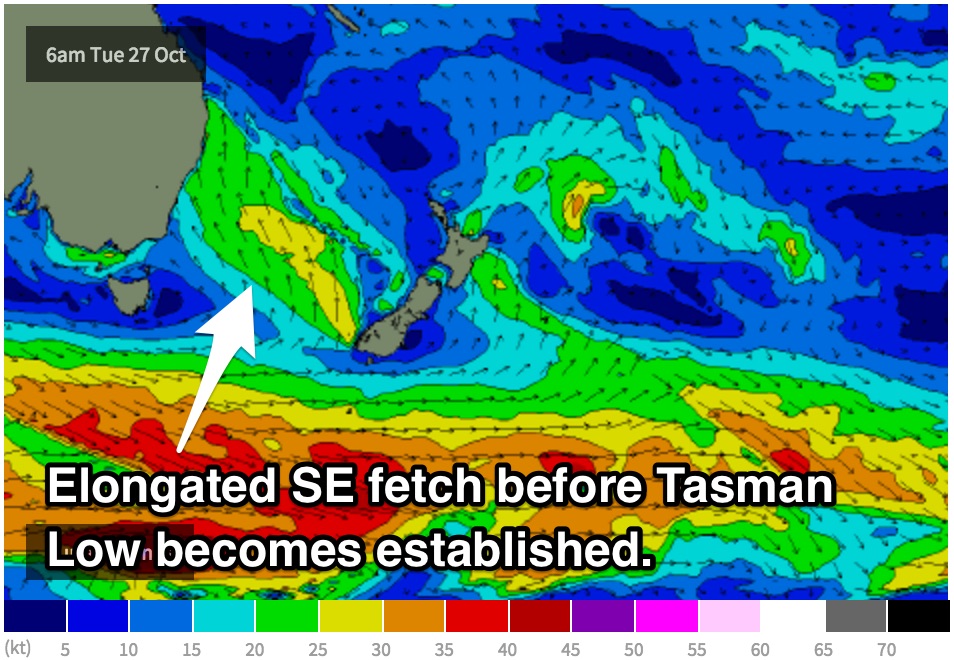
To make the situaion more complex, a short range southeasterly swell will also contribute to Wednesday’s size generated by the early stages of a developing Tasman Low. Southeasterly fetches will become elongated throughout Monday evening, with good alignment throughout Tuesday. As the low becomes well established on Wednesday, the alignment of the fetch on the western quadrants will be more suitable for southeast QLD as opposed to NSW.
Size wise, Wednesday afternoon should also see around 3-4ft off this system alone, with open beaches doing well.
Although a light southeasterly breeze will dominate along the coast for much of the Wednesday, the morning session will offer light/variable winds, easily the pick of the bunch. As the day progresses, winds will increase, but only marginally.
Thursday should see another morning of fun conditions under light winds. Conditions are likely to be clean and workable right along the coast under light/variable breezes preceding a light onshore flow in the afternoon. Head out early to snag a few in the 3ft range, occasionally bigger before it fades throughout the day.
The surf should ease further from the 2ft to maybe 3ft on Friday at south facing beaches, with the easing trend slowed only by hints of background southerly energy generated by poorly aligned and poorly defined frontal activity. The only redeeming feature of these fronts are that they're virtually continuous, allowing the surf to hold in the 2-3ft range right through the weekend.
Northeasterly breezes are likely to rapidly increase around mid-morning, so be sure to make the most of Wednesday and Thursday, or hit it early on Friday at a south facing beach.
This weekend (Saturday 31st - Sunday 1st):
By the weekend, we should be left with inconsistent southerly background energy which will provide surf in the 2-3ft range for south swell magnets only. Open beaches will suffer from the swell direction with very little energy filling in, however Sunday should see an element of northeasterly wind swell building to the 2-3ft range, bigger on the South Soast.
Northeasterly breezes are looking to dominate along much of the coast, with very few windows of opportunity for a wave. Each morning will offer the lightest winds, but they should only tend north/northwesterly at best. The Hunter will be the pick for the weekend by highlighting small swell under northerly component winds.
Next week (Monday 2nd onward):
The aforemention northerly breezes are likely to whip up a northeasterly wind swell for Monday, with the potential for peaks in the 3ft range.
All swell windows look to remain fairly dormant otherwise, with the exception of subtle and insignificant frontal activity keeping a small amount of southerly energy in the water.
Early indications suggest that Wednesday may be the best best chance of significant swell energy off a potential Tasman Low, but confidence remains pretty low this far out.
Comments
The wind outlook for Wednesday morning has deteriorated in the latest model runs.
Some models now indicate a light/moderate southeasterly flow first thing, as opposed to light/variable breezes as mentioned in the notes.
Will keep an eye on model update this evening.
The latest model run looks more like the original scenario.
I'll put my money on light/variable winds for the early.
Hows it looking for Thursday morning Guy... bit worried it might be small. Outside chance for some 3-4 footers at the magnets??
I still think Thursday morning looks good for surf in the 3ft range, although 4ft sets now look a bit ambitious. I'll have a detailed forecast out tomorrow afternoon for you.
Cheers.
Despite the onshores, Newy doesn't look too bad this arvo.