Not much until next week

Sydney, Hunter and Illawarra Surf Forecast by Guy Dixon (issued Monday 12th October)
Best Days: Monday
Recap:
Remnant southerly energy in the 2ft range was on offer across the Sydney and Illawarra stretch on Saturday morning under light offshore breezes. The Hunter offered a touch more size, however breezes quickly became an issue across all coasts, swinging onshore and increasing slightly in the afternoon.
Sunday saw more energy in the water, with south facing beaches across Sydney and the Illawarra in the 2ft+ range and the Hunter in the 2-3ft range. The morning northwesterly breezes held on for a lot longer, keeping condition clean and workable until mid/late morning, despite the tide swallowing up a lot of the energy. We were expecting a local northeasterly breeze to increase late yesterday afternoon which would provide an element of peaky short range energy, but this scenario never really eventuated.
As a result, the surf has faded today and exposed south facing beaches are offering inconsistent sets in the 2ft range.
This week (Tuesday 13th - Friday 16th):
The warmth we are feeling today is as a result of hot air being filtered over the region ahead of a low pressure trough. As the axis of the trough moves over head this evening, a cool and gusty southerly change will move up the coast, whipping up a short range wind swell. The strongest winds will be moving with the change itself, rapidly easing in it’s wake.
By Tuesday, a lot of the short range southerly energy that was generated by the change will have dissipated, leaving poor quality peaks in the 1-2ft range at south facing beaches, slightly bigger across the Hunter. Protected southern corners of the open beaches will be offering much cleaner conditions, however due to the short period of the swell, a lot of this energy will fail to refract in.
Light variable winds are on the cards for early Wednesday morning preceding an east/northeasterly seabreeze. In terms of surf, there isn’t likely to be much on offer. A peaky mixture of remnant southerly energy and short range easterly wind swell generated by a ridge sitting over the Tasman should provide lacklustre peaks in the 1-2ft range
The aforementioned easterly fetch will continue to provide peaky short range energy in the 1-2ft range for open beaches on Thursday. The morning session will definitely be the best time to get wet as a north/northeasterly breeze is likely to freshen throughout the day creating bumpy conditions at the beaches with the most size.
These fresh north/northeasterly breezes will continue through the night long the coast whipping up promising northeasterly wind swell for Friday. Finding a workable option will be the hardest part. It’ll be a balancing act between heading to an open beach to gain the most size, but being protected enough so the surf isn’t affected by gusty northerly component breezes.
This weekend (Saturday 17th - Sunday 18th):
A southerly change is looking to move up the coast on Saturday morning. There is a fair bit of model uncertainty regarding the timing of this change however.
Some models have a rapid change under the cover of darkness in the early morning, while other show a gradual change with periods of slack winds in the morning. With time and more model runs we will have more idea on which scenario will play out.
In either scenario however, the swell generated will be short range and lacking any sort of quality. Underlying northeasterly energy will still be in the water, so there should be options in the 2ft range at most beaches, cleanest at protected southern corners.
Sunday will see all coasts fade back to the 1-2ft range under moderate southeasterly breezes.
Next week (Monday 19th onward):
It’s a long way out, but the next best chances of a decent southerly groundswell filling in along the coast will be on Monday. A healthy sized west/southwesterly fetch will move south of Tasmania and across the Tasman throughtout Saturday.
The alignment of the 35-45kt core winds is pretty ordinary, however south facing beaches can still expect sets in the 3ft+ range on Monday morning.
Winds look to be light and variable, at least for the morning session under a dominant ridge of high pressure.
Another interesting swell source to take notice of is a tropical depression forming south of Fiji later ths week. An intensification of an easterly fetch on the southern quadrants of this system has the potential to provde us with an increase in E/NE swell around Tuesday. We will have a deeper look in the next few forecast notes.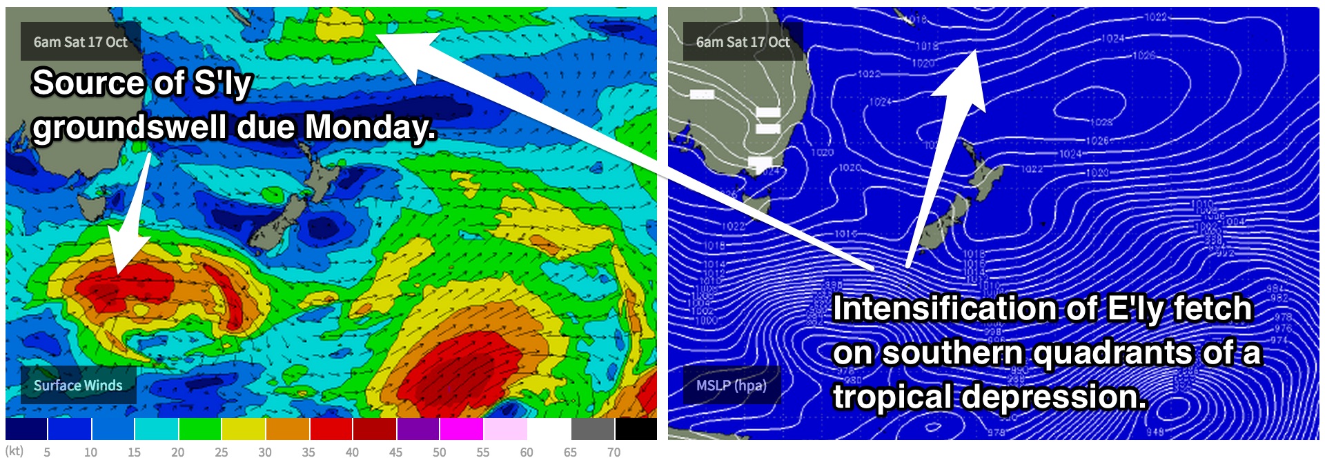
Comments
Next time you're umming and ahhing whether clean 2ft surf is worth the effort, just remember days like today. What a mess!
Surprisingly still some small NE windswell to 2ft on the sets in the mix.. I shouldn't have slept in..
hey ben. the forecast notes already covered this but is there a chance for anything ridable at the most absolutely reliable south swell magnets tomorrow?
Sorry mate, missed this - Guy is doing the Sydney notes now so you'll have to hit him up.
Geoffrey,
There is an element of underlying S'ly groundswell which will provide small peaks at the magnets, but it's pretty modest. The screen grabs that Ben just posted below are a good representative of the magnets , probably as good as you'll get today.
Fresh notes to come later on today.
Coupla small options at Bondi this AM. Looks to be affected by the overnight onshores though.