Initially small, ahead of a long stretch of strong south swell

Sydney, Hunter and Illawarra Surf Forecast by Ben Matson (issued Wednesday 6th May)
Best Days: Fri: new S'ly swell building during the day. Sat/Sun: strong S'ly swell. Mon thru' Thurs: three pulses of S'ly swell, all of 'em possibly large.
Recap: Lots of fun waves on Tuesday morning with an easing E/NE swell and light offshore winds. Smaller conditions presented themselves this morning, and unfortunately today’s expected E/NE swell has fallen well short of expectations - set waves are nudging 2ft+ at some exposed beaches but many beaches are devoid of banks, so the straight swell lines are closing out. It's a real shame too as conditions are first class. As for why the swell didn’t quite get there - it seems the NE fetch responsible was aimed just a little outside of our swell window (i.e. more towards the south, than the south-west) so we’re seeing smaller sideband energy from it. The lines are much more consistent this afternoon and the Sydney spectral buoy did observe a slight increase in energy around 1pm this afternoon (its data is erratic, we have only had three updates since 10pm last night). One positive from this is that our swell model was spot on for this event!
This week (May 7 - 8)
’Tis a shame the E/NE swell didn’t really do much this afternoon as we’re now looking at much smaller surf through Thursday.
Based on today’s lacklustre performance I’m going to keep size expectations low for tomorrow, with the E/NE swell likely to maintain inconsistent 1-2ft waves at open beaches. A small south swell originating from a gale force westerly flow through eastern Bass Strait should provide small waves at south facing beaches, but I don’t think we’ll see much more than a foot or two here either.
Conditions will however remain lovely with moderate to fresh W/SW winds.
On Friday, similarly small conditions will persist through the morning but a new south swell is expected to push through the middle of the day (earlier along the South Coast) and this should provide good waves at south facing beaches. This swell will be generated by the same vigorous airstream existing eastern Bass Strait, except it’s expected to veer a little more W/SW through Thursday which should align it better within our swell window.
There’ll be a large range in wave heights owing to the swell direction, but some south facing beaches in Sydney should pick up 3-4ft sets through the afternoon, with bigger bombs in the Hunter. Winds should hold from the west so again, conditions are looking nice and clean.
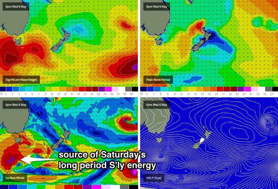
Also, the South Coast may see a very late arrival of new long period south swell generated by a much deeper, more powerful low tracking below Tasmania today (see chart below). The leading edge of this swell (Tp 18-19 seconds) is due into the Far South Coast late afternoon, but it’ll probably be hard to distinguish beneath the mid-range southerly energy. Nevertheless, if you’re looking at buoy data and notice a jump in peak swell periods, this is what will have generated it.
This weekend (May 9 - 10)
The new long period south swell mentioned above should fill into remaining southern NSW beaches overnight and will work in tandem with pre-existing mid-range southerly energy to produce some great waves at south facing beaches on Saturday. Winds are expected to remain westerly both days so surface conditions should remain clean at most beaches.
As for wave heights, we’re probably looking at inconsistent sets in the 3-5ft range at Sydney’s south facing beaches, with bigger 4-6ft sets across exposed Hunter beaches. Smaller surf will prevail at beaches not open to the south. A slight easing trend is likely into Sunday but there should still be plenty of great waves on offer. Sunday’s surf will probably be reinforced by another pulse of southerly energy originating from yet another front pushing across Tasmania overnight Friday, but this one looks like it’ll resume more of a zonal flow (west-east) and will therefore be less beneficial to the NSW coast.
Also in the mix over the weekend will be a small undercurrent of long range E/NE swell, of tropical origins. However no great size is expected from this source.
Next week (May 11 onwards)
Another strong succession of fronts are expected through the southern Tasman Sea over the first half of next week, and current model guidance suggests they’ll be more meridional (north-south) in alignment, which means they will have a much higher size potential than the upcoming pattern for this weekend.
At this stage, the first new swell is due in on Monday, with a followup on Tuesday and then a third large swell later Wednesday or maybe early Thursday. Each swell has the potential of generating easy 6ft+ sets at south facing beaches, but we’ll have a better idea on the precise size and the timing in Friday’s update.
Comments
Ben,
A while back we had a quick chat regarding the LWT.I mentioned that it would be good if it would stall again in a similar region like in July 2011.You mentioned something regarding high pressure over the south pole and that you were looking to study it in more detail.I was interested in your thoughts as we finally have something similar in the synoptic charts right now.Thanks
Unfortunately I haven't had too much time to look into that in more detail. But the upcoming pattern does look particularly good for an extended spell of strong south swell. I'll see if I can dig out some charts of the July 2011 event to see if there are any similarities.
all i see is west, west and more west in the charts. the south fetch is a long way down so i'm not getting my hopes up too much for that late Fri/Sat south swell. but i'm just a pessimistic pleb.
early next week though..
That's a worry, I'm thinking of a trek into national park around lunchtime Friday for this.
Only small this morning but jeez it looks attractive...
fun fun
Hmm, fill your stockings up!
Very nice!