Developing Tasman Low to dominate Thursday onwards

Sydney, Hunter and Illawarra Surf Forecast by Ben Matson (issued Monday 8th December)
Best Days: Tues: fun leftover NE swell in southern corners (winds will be out of the south). Thurs: tricky winds but there should be a small NE swell in the water, with the possibility of a late increase in new swell from a Tasman Low. Fri/Sat/Sun: solid SE swells but dicey winds at this stage. Next week: some great potential on the cards.
Recap: What a tidy run of waves! Small building NE swell Saturday that increased further through Sunday and peaked this morning with solid 4ft sets at exposed beaches. Winds were generally light north of Wollongong for much of the period, although Saturday saw strengthening E/SE winds on the South Coast as a low briefly developed offshore (this also added a small SE swell to the mix). Sydney buoy data is showing a steady easing trend although the Manly cam still has easy 3ft sets.
This week (Dec 9th - 12th)
The fetch responsible for today’s NE swell is weakening across the western Tasman Sea, so we’re looking at easing NE swells through Tuesday.
Early morning should still have 2-3ft sets at NE facing beaches (smaller at south facing beaches, and in the northern Hunter) and although a gusty overnight S’ly change is expected to ease rapidly in the few hours before dawn, we may see a lingering southerly flow across open beaches for a few hours around dawn (changes for a light SW flow are minimal, and likely to occur at only a handful of spots).
As such, southern ends will offer the best waves as they’ll pick up the most size and offer some protection from any lingering strength in the wind. By mid-late morning winds should be light and variable at most locations. However, the overnight southerly change won’t kick up much in the way of new swell, just a weak foot or so of low quality windswell. Expect smaller, less consistent surf from the NE through lunchtime and into the afternoon.
A weak secondary front traversing the southern Tasman Sea behind Monday’s change (into Tuesday) will then maintain small levels of south swell for Wednesday, whilst residual E/NE swell from the weekend’s trade flow across the northern Tasman Sea should keep remaining open beaches with a foot or two of inconsistent surf. Early light N/NW winds are expected to tend NE and freshen considerably through the afternoon as another trough envelops the coastal strip.
This developing trough looks like it will finally break the recent pattern of persistent NE winds and swells. A small low (low chance of an ECL, but let’s wait and see) is expected to form somewhere within the trough in the early hours of Thursday morning, but the timing is not agreed upon across the model runs right now so we need a high degree of elasticity in the forecast.
Thursday’s surf will therefore mainly consist of peaky short range NE swell (2ft, maybe 2-3ft NE facing beaches, smaller elsewhere) but as the low winds up we’ll see a building short ranger E/SE swell.
Local winds are also tricky for Thursday because we’ll see a wide range of strength and direction - south of the developing low’s axis it’ll be gusty E/SE, but north of the axis - at least temporarily, until the low slides away from the mainland - there’s likely to be an outflow from the W/SW (and maybe even NE prior to this). Current model guidance has this happening around Sydney/Hunter beaches but let’s wait for Wednesday’s updated data.
This E/SE swell is expected to become the dominant factor through the end of the week as the low broadens and moves north-east, taking shape in the central Tasman Sea. Regardless of the divergent model guidance, Friday is like to finish with sizeable short range SE swells and gusty SE winds (lighter on the South Coast).
Also worth mentioning is a small SE groundswell due in the mix on Friday, originating from a small low modelled to form off the SW tip of New Zealand’s South Island. It’ll be buried under the short range noise but at locations such as the Far South Coast - where local winds will be much lighter - could provide some reasonable lines of groundswell in the 2-3ft range.
This weekend (Dec 13th - 14th)
We’re assured of surf this weekend, that’s for sure. But quality is another question altogether. The Tasman Low looks like it’ll remain a firm synoptic feature through this period, with a broad SE fetch stretching north-west from New Zealand’s West Coast up into the southern Coral Sea.
This will generate strong SE swells for Saturday at least - easing through Sunday - but local conditions look like they’ll be bumpy with moderate onshore winds. By Sunday we should see a rapid improvement however surf size will probably be dropping (some other models focus the low as a strong cut-off system, generating strong swells for the entire weekend, but I’lm less confident that this will occur).
Let’s give it a few more days to firm up the specifics but right now it won’t be too hard to find something fun and punchy, even if you have to sneak into a southern corner on Saturday to escape the initial bumpiness.
Longer term (Dec 15th onwards)
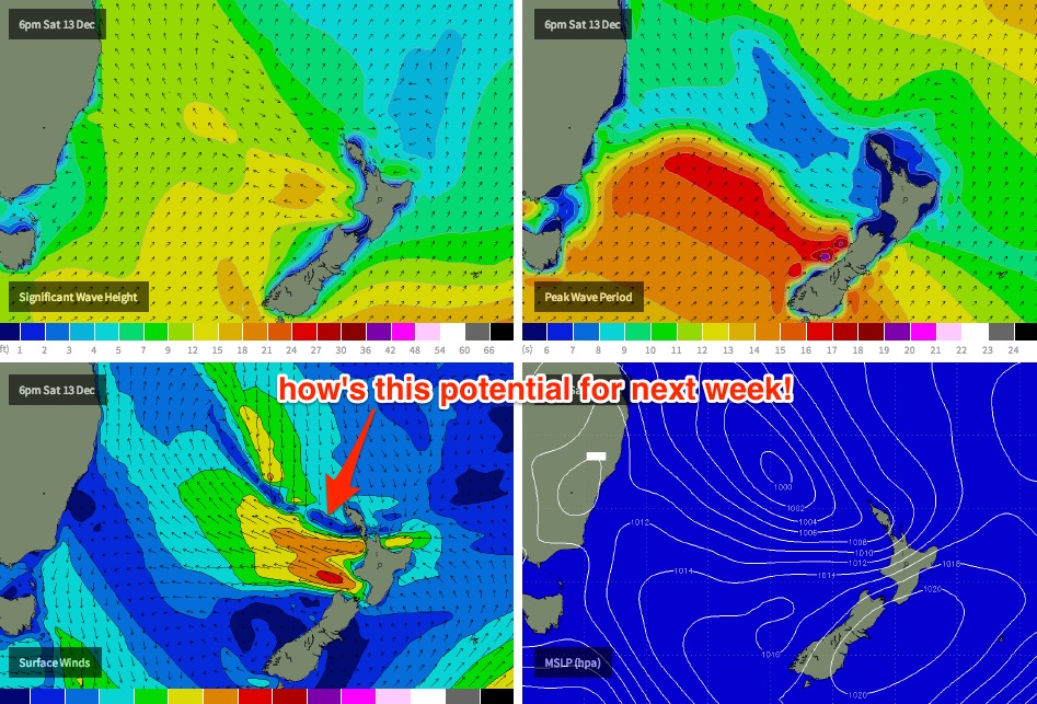
Next week has some really interesting possibilities. The latest model guidance is showing a deepening E/SE fetch off the West Coast of New Zealand’s North Island over the weekend, one of my favourite swell windows (see below).
It’s still quite a long shot but right now there’s a reasonable chance that we’ll see a solid long period E/SE groundswell pushing through early next week (say late Monday, or early Tuesday) in the 4-6ft range at most open beaches. I’ll take another pass at this in Wednesday’s update, but for now the long term period through the weekend and early next week looks very active for all East Coast surfers.
Comments
All very interesting Ben. Things have been more active than usual this spring/early summer. We have hardly been to dribbletown at all.
B.o.m. shows that low going 986 sunday arvo.
bb ,
Borderline El Niño' s influence has finished early .
And best yet , with warm waters currently surrounding 95% of the continent the next 12-18 mths could be up there as one of the best periods for surf on the east coast
Thanks southey. This year was pretty good so any advance on that will have the punters pretty happy.
Don't hold me to it !!?!
But does the last six years remind you of conditions in the seventies ?!?
Definitely southey. The beaches tell part of the story. They are still sloping steeply after the winter erosion and will not fully recover this summer. The downside of the activity is that the banks just keep getting worse the longer it goes on. It was best part of a decade before they fully recovered from the mid-seventies. But I'll take the swell anytime! Too many bad memories of totally flat summers and sunny offshore winters with minimal swell.
There's always reefs . Who misses sandbanks when the there's consistent swell . Probably doesn't do much for crowding though . Maybe the seventies was only good because the surfing population was way less . So points and reef breaks didn't overload . Besides only half the surfing population was in the water at any one time , sometimes some guys didn't /couldn't find the water whilst LSD was abundant. ? Maybe those years were just viewed through " rose coloured " glasses ....
Well something was rose coloured southey but I'm not sure it was the glasses. In truth a lot of people hated that period, particularly those years we just got smashed with a major south swell every week from May to September. There were no banks most places and not many places like a strong south swell. It just sails past a lot of points and closes out the beach breaks.
That's funny blindboy. I've been thinking that is has been classic spring rubbish, pretty much consistently for the past 3 months, hardly a good days surf in the whole time. This afternoon seemed to be the best I have seen it for ages. So did the 300 blokes at my local. :-)
It's been the dribbletown express.
I can't work out your comment regarding winter erosion. I've never seen so much sand on the beaches, from Maroubra to Central Coast, where I regularly visit.
The only thing I have noticed recently is that finally a metre or so of sand has been taken from Maroubra around the shoreline recently, but that just brings that small part of the beach back to about normal height, with the rest of the beach fully two metres higher than 'standard', if there is such a thing. Phenomenal sand build up.
Such different perspectives.
This low will finally, hopefully, put some of the sand back in the water, rather than on the beach.
Wonder what others think. I thought it was a particularly quiet winter.
There are still steep slopes and big scarps on the beaches where I am batfink. As for the surf, it has been worth a dig most days and I wouldn't usually say that about the October - December period. Similarly I thought this winter was above average in consistency .
Talking bout sand, Is it the case that autumns banks are usually good because summer north east wind/swells push sand in the southern corners so when the first south ground swells come they're lined up or is that urban myth?
No myth scouser. It is definitely a factor. If there are lots of small NE swells sand gets transported south and forms the banks in the southern corners. I think the exact direction of the beach and the type of sand are also factors. Some beaches have loosely packed sand which moves easily others require a bit more energy to get moving. Smaller winters can do the reverse. The southerly longshore drift pushes sand north. The problem this year for a lot of places was that the sand went north and OUT in the larger swells. There are spots which benefit from this but not as many as are trashed. It will move back in the smaller conditions over summer but I'm not expecting much in my local northern corner this year.
I'm with Blindboy on the good run of swells through Spring and now into the start of Summer.
Been everything from an out of season East Coast Low, to fun S'ly groundswell pulses with N'ly winds and this recent NE tending E/NE swell event the last week and a half. Have scored sick waves the last month, and the only down period in Sydney coincided with a tripI did to Tassie getting cold water wedges. And there's more on the cards this weekend and into next!
Basically if Sydney has a south swell in most cases the whole of the northern beaches is wiped out. Get a big south swell well we need a nth east wind and box head is on offer otherwise it marches straight past the whole of the northern beaches . Bring on east north east or south east swell and we can deal with any winds and find a cracking spot
Just got out from surfing crescent 2 to 4 ft peelers smooth but my goodness the holiday crowds are here mixed with a very heavy local scene give me manly any day
Yeah BB, I agree there are big slopes of sand on the beaches, but not because it has been taken away, but because it has built up incessantly pretty much since last spring, with very few intervening clearing swells. I can't recall there being so much sand on so many east coast beaches. Some central coast beaches that used to be a 25 metre walk from the dunes are now 50-70 metres away. Honestly.
I'm not going to argue with you Craig in terms of knowledge of what has gone on, I just not sure we are speaking in the same relative terms. It hasn't been abject flatness (except when it was) but I can recall only a few days when it has challenged head height, and so many onshore rubbish days barely topping knee high.
Before last Saturday morning, this week's swell from Tuesday, and next week's swell, I can't remember an overhead day. Last weeks rubbish nor east pox on humanity was classic east coast spring rubbish.
What East Coast low are you recalling, or is that a reference to next week's event?
P.S. I have now entered the age where remembering what I had for lunch requires extensive silence and contemplation, but honestly, I have been out in that 1-2 foot onshore mush on a lot of those days, and I think I would have remembered something remotely overhead.
Cheers guys, not arguing, just debating. I have been watching and lamenting for most of September, October and November, and cancelled at least 3 weekend surftrips due to dire forecasts.
Cheers
Batfink sediment transport is one of the more difficult natural processes to model so I think we are just looking at different effects at different locations. Events that erode one beach might easily end up dumping sand at another. The chain link and wooden cross struts are hanging off the end of the walkways where I have been surfing for the last couple of weeks and coming in I need a run up to get over the scarp. That is not deposition, it is erosion. I have known this beach since my family moved in to the area in 1961 and the only time I have seen it more eroded was after the storms of the mid-seventies.
Nup, mid October, big ECL and 10-12ft S/SE swell across Sydney. I got some sick ones at the local reef.
This was around your neck.. https://www.swellnet.com/photos/swellnet-sessions/sydneys-eastern-suburbs
And for the past month and a half at least once a week Manly has reached 3ft and has been glassy at the peak of each NE windswell pulse. Been super fun around the beaches.
And Peter, plenty of east in next week's swell.
Possibly not much beach left afterwards though.
I had a look back at some other forums regarding spring surf conditions. There was an ECL on 3rd September or thereabouts, but I was just counting that in the 'late for winter group.
Missed the ECL of October while I was in Bali. :-) of course, but as I recall that didn't last much, but certainly was out of season.
And the overhead conditions of the previous Saturday (28th Nov?) only just made it into Spring.
Surf always looks much better if you can grab those 15 minutes when the going is good Craig, but for us family disposed knobs not working in the swellnet offices who can't walk out at those odd moments of bliss .................
Interesting sand obs BB.
So much sand on the beaches that I attend, and hoping with not much expectation that this weekend and following will take some of it out and deposit it as well constructed sand banks.
But that never happens.
Are you coal coast BB?
Wish we could walk out at those odd moments of bliss into the surf, but here in North Sydney it's onto a busy street..
I just put in a lot of effort to chasing waves before/after work and especially on the weekend. Also not tied down with kids etc.
Here's a small peak of what I've found over the last couple of months.. (mainly over the weekend and with a small Tassie trip in the mix)
http://instagram.com/craigbrokensha