Fun weekend ahead, Monday looking punchy

Sydney, Hunter and Illawarra Surf Forecast by Ben Matson (issued Wednesday 8th October)
Best Days: Saturday: peaky NE windswell with an early period of offshore winds. Monday: strong short range NE swell with an offshore change possible through the day.
Recap: Tuesday’s NE windswell punched a little above its weight (consistent 3ft sets at open beaches), and as expected there was a good period of offshore winds through the middle of the day. This swell evaporated overnight, with a building south swell today offering average quality waves at open beaches under a moderate cross-onshore breeze (reaching 2-3ft at south facing beaches this afternoon).
This week (Oct 9-10)
Nothing of major interest for the rest of the week. All of our primary swell windows have been relatively inactive for the last few days, and will remain so until the weekend. As such we’re generally looking at small residual swells at exposed beaches.
Wind wise, we’re looking at light winds early Thursday tending moderate north-east in the afternoon (Thursday morning will be your best chance of a wave, catching the dying remains of today’s meagre south swell).
On Friday the NE breeze will ratchet up a few notches as a trough develops along the coast, in fact we should see a slowly building, but ultimately low quality NE windswell throughout the day that should reach 2ft at exposed beaches through the afternoon, possibly some 2-3ft sets close to dark. Expect tiny conditions at south facing beaches, and in the northern Hunter.
Unfortunately gusty NE winds by this time will render conditions quite bumpy, and the short period nature of the swell will result in low strength surf, but there’ll be a small wave on offer if you’re keen.
This weekend (Oct 11-12)
Model data for the Friday/Saturday time period has been a little divergent over the last few days but they’re now starting to hone in on a nice window of waves to kickstart the weekend.
Friday’s strengthening nor’easters are expected to persist overnight but then weaken into Saturday morning as the trough pushes off the coast. This should generate a peaky NE swell in the 2-3ft+ range at exposed NE facing beaches for Saturday morning, and the good news is that at this stage we’re looking at an early westerly breeze to keep conditions clean.
Wave heights will probably ease a little into the afternoon though, and winds will veer NE again (north of Sydney). The South Coast will probably see SE winds develop in the wake of the trough though. I’ll firm up the specifics of this in Friday’s notes.
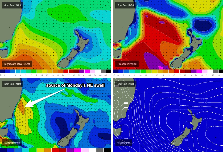
Sunday is expected to be characterised by early light winds strengthening from the NE in the afternoon as the coastal trough redevelops, along with a temporary drop in size (from Saturday) ahead of a rebuilding trend in local windswell as the winds increase. At this stage we’re looking at a peak in NE windswell through Monday but very late Sunday could certainly see some 3ft+ sets at NE facing beaches if we’re lucky, although it will probably be bumpy.
So the short version: aim for Saturday morning at a NE friendly beach. Which conveniently happens to be the vast majority of the southern NSW coast.
Long term (Oct 13 onwards)
Most models have this coastal trough reaching maturity on Monday afternoon as a southerly change advances along the coast (see chart below).
Right now, wind strength, the timing of the change and the size of the surf is all a little up in the air but it’s a fair bet that we’ll see 3-5ft sets at exposed NE facing beaches on Monday, and there’s a reasonable chance that we’ll also see a wind change throughout the day (most likely early N’ly, then W’ly, then S’ly - with southern locales seeing this formula several hours earlier). The South Coast may see bigger sets from this source, depending on how the fetch lines up.
Beyond Monday the models get a little hazy, suggesting a low may form off the coast with a wide range of swells - some leftover NE windswell from Monday, a moderate S’ly component in the lee of Monday’s change and a building short range SE swell as the low starts to wind up.
It’s too hard to pin down specifics right now but it’s well worth you putting the time frame between Tuesday and Thursday into your diary as it’s quite likely that we’ll see a dynamic weather event unfolding across our immediate swell window that could very well deliver some sizeable waves to southern NSW. More on this in Friday’s notes.
Also, there are several additional swell sources expected to develop in our far E/NE swell window (just north of New Zealand) through this period but right now the Tasman system looks like it’ll be the focus of our attention. So I’ll concentrate on that for the short term and discuss the broader implications of the long range swells in later updates.