Improving Sunday, great Monday

Sydney, Hunter and Illawarra Forecast by Craig Brokensha (issued Friday 15th July)
Best Days: Early Saturday, Sunday afternoon, Monday, Tuesday morning, Wednesday morning in protected spots
Recap
Moderate levels of S'ly swell continued across south facing beaches yesterday morning to 3ft on the sets with light offshore breezes through the morning, but this gave way to a fresh S'ly through the day and choppy waves into the afternoon.
Today a reinforcing S'ly groundswell has provided more power with 3ft to occasionally 4ft sets across south facing beaches and smaller 2-3ft waves at open locations. Conditions were again good with a light variable tending offshore breeze and we should see the swell hang in most of the day with a weak E/SE'ly breeze into the afternoon.
This weekend onwards (Aug 16 onwards)
One final pulse of long-range and inconsistent S'ly groundswell is due later today and tomorrow morning across the coast, generated by a very strong polar front pushing up and into New Zealand yesterday while generating a fetch of severe-gale to storm-force SW winds.
While not ideally in our swell window we should still see good levels of side-band S'ly groundswell energy spreading up and into us, keeping inconsistent 3ft sets hitting south facing beaches tomorrow morning (larger across the Hunter) ahead of an easing trend into the afternoon.
Conditions will be best early with a light variable tending offshore wind, but the afternoon will become poor as freshening E/NE winds start to move in.
These onshore winds will be related to a deepening inland surface trough slowly moving east towards the coast, squeezing the western flank of a strong high in the Tasman Sea.
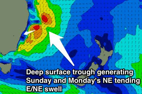 The intensity of this system has been upgraded since Wednesday and we're now looking at a solid increase in NE swell through Sunday as the surface trough moves offshore and continues to deepen.
What this will result in is a gradually strengthening fetch of NE winds being aimed right into us from Saturday afternoon, reaching the gale-force range into Sunday afternoon as the trough moves offshore.
North-east facing beaches in Sydney should build from 3ft+ early Sunday to a larger 3-4ft+ into the afternoon as poor morning N/NE winds slowly swing offshore from the NW during the day (around dark on the South Coast).
The trough should continue to aim a fetch of NE gales through our swell window until early Monday morning before it drifts too far south.
This should produce some stronger E/NE swell for Monday, coming in at 3-5ft across open beaches during the morning before easing slightly into the afternoon. The South Coast will be larger due to the fetch being aimed better towards the region along with a longer fetch length. South facing locations will be a lot smaller along the the Hunter region.
Conditions look excellent Monday with a moderate W/NW'ly expected to persist all day, so there's no rush to surf early.
Now, this won't be the end of the swell from this system as broad low pressure system will form in the trough through Monday, with a fetch of strong E/SE winds on its southern flank developing in our swell window during the day before a fetch of S/SE gales are projected up the Southern NSW Coast Tuesday.
What this should result in is E/SE swell to 3ft or so across open beaches Tuesday morning giving way to an afternoon kick in S/SE swell to 4-6ft across south facing beaches. Winds will be an issue though, swinging from a fresh to strong SW'ly early in the day around to the S/SE during the morning.
The swell Wednesday morning is likely to be in the similar 4-6ft range out of the SE but conditions look poor with a fresh to strong S/SW tending S/SE breeze as the swell drops through the day. The Northern Beaches are likely to see more favourable SW winds through the morning.
Longer term a slow drop in SE swell is expected into the end of the week with less than favourable winds, but we'll look at this again Monday. Have a great weekend!
Comments
Swellnet!!!!! Why is your swell forecast for Monday have S winds and you say the following. WELL WHICH IS IT????
Conditions look excellent Monday with a moderate W/NW'ly expected to persist all day, so there's no rush to surf early.
The BOM forecast has the wind switching SW and strengthening from the middle of the day so things have probably moved a bit more rapidly than expected. Definitely a morning session though!
Calm down mate. The swell graphs are automatically generated by a computer model, four times a day. They have no Quality Control by human forecasters (we have 2,500 locations internationally so it’s logistically impossible to tweak them all four times every day).
My and Craig’s detailed forecast notes are written three times per week (Mon/Wed/Fri), of which the last notes were done on Friday - so they’re currently three days old. By contrast, the BOM have the luxury of employing a large number of forecasters nationally, who update their written forecasts several times per day as the models change under complex situations. Swellnet has only two forecasters, one of which (me) was OS last week.
Anyway, right now we have - according to the BOM - “a complex low pressure system located off central parts of the coast”, which is causing a difficult forecast situation for Monday.
To highlight this, the BOM have for the Illawarra coast (Mon): "Northwest to southwesterly 15 to 25 knots becoming variable about 10 knots before dawn then becoming south to southeasterly 25 to 40 knots early in the morning.”
But for the Sydney coast (i.e. north of Cronulla), the BOM have for Monday: "Northwesterly 10 to 15 knots shifting south to southwesterly 20 to 30 knots in the early afternoon. Winds reaching up to 40 knots during the afternoon and evening.”
So, according to the BOM we're going to see a gale force southerly change "early in the morning” across the Illawarra but "in the early afternoon” from Cronulla north. The Coal Coast will be somewhere between this, so I’d recommend surfing early as winds are likely to swing gale force southerly during the morning.
We'll said Ben
Did Anyone see me get barreled today at Mariubra ?? I was on fire . Had / 2 people tell me I wS rippin.
As Ben stated Kerry, the system has changed a little from Friday, it didn't push as far south and is now coming back up earlier.
Also with the low not moving as far south, this is why it's a little bigger this morning than my expected 3-5ft. The fetch stayed within our swell window for longer and was much better aligned.
Its double overhead on the sets at Mantown and the Southerly change just hit. Cooking !
Can confirm @mick-free, Mantown is all-time. The rain has flattened the bumps out nicely and there are some legit freight-train lefts steaming through. Fearsome rip from the second pipe heading south though, be careful and pack the denco-rub! Shame i'm back in the office! Enjoy it all you mugs with the day-off!
Also, Thermal, really cool to read how the forecasts and models work. Cheers for the heads up!
Sat in a lonely wind and rain swept carpark for about 3 hours yesterday waiting for the fucking wind to change. I continuously checked the cameras - Manly pumping! Shark Island glassy! - and monitored the real time wind obs up the coast. Norah Head NW, North Head NW, Kurnell just gone NW. Everyone north of me was getting great waves. My plan was to wait for Wattamolla to go NW and then I'd get into my wetty and be first in the water - laughing!
I waited...and waited. Read The Saturday Paper while waiting, good article from Paul Bongiorno about the state of the Abbott government, Mike Seccombe also wrote a great story on ICAC. Checked Wattamolla, still SE. Impatiently checked Manly surfcam - blue sky, offshore and pumping. It'd been that way for three hours. It should be doing it here.
Finally at 3:30 Wattamolla went slack so I paddled out in the pissing rain thinking it'd be offshore in 20 minutes. Didn't happen. Hindcast shows the trough didn't reach as far south as expected. Stopped about 20 ks north of me. Still, had an OK surf and I'm fully up to date with state and federal politics.
Haha Stu, ICAC fascinating stuff....it was pretty crowded but if you had set the compass northm you would have got the last hour which was the best of the day....
Ask me anything about ICAC, Mick, but don't ask me if I got any barrels yesterday.
Wattamola !?
Wot?
Nearest weather station to the norf.
Sorry mate, I thought you were in the car park at Wattamola.
Might as well have been...
Why does Australia have 3 levels of government, why don't just dissolve this state bullshit??
My knowledge is limited to ICAC Mick, but I assume it's to give Queenslanders and West Australians something to whinge about. As in: "Our states support the rest of the nation."
The poor sods from those states need all the moral sandbagging they can get so state politics allows them to do that before the mining industry falls in a heap - and WA and QLD with it.
And all WA will be left with is crystalline waters and pristine beaches that would erode severely but for the beautifully shaped reefs guarding them from powerful ground swells and populated with an amazing array of sea life.....with kilometre after kilometre of coast uninhibited by humans. Poor fuckers.
I'd say that WA has got a bit of gas left in the tank yet Stu.....wait till the Kimberley's gets opened up . It will be a crying shame and the return to the West Australian people will be of the slimmest percentage of profits generated but at least NSW will have someone to continue leaning on .
I through that last bit in just for you. You like ?
Just like WA leaned on the eastern states for...oh, the 100 years between federation and the mining boom.
Right back atcha....
Gold rush, wool boom, iron ore for decades, Rolf Harris .....Maybe forget that last one.
shame about the winds, great swell.. a mate reckoned there was a late change in cronulla yesterday, but it looked like a foamy mess all afternoon round the gong