Great waves most days

Sydney, Hunter and Illawarra Surf Forecast by Ben Matson (issued Wednesday 11th June)
Best Days: Thurs: clean but easing SE swell. Fri: fun clean E/SE early, with a strong E/SE groundswell arriving after lunch. Sat: easing E/SE swell with offshore winds. Mon: strong, windy S’ly swell. Tues: easing S’ly swell with light offshores.
Recap: Peaky mix of SE swells on Tuesday with early offshores swinging onshore during the day. Similar round of peaky SE today with a new groundswell starting to fill in this afternoon. Early light offshore winds tending S’ly during the a’noon.
This week (June 10-13)
Looking like a good finish to the week. Today’s new SE groundswell will peak overnight and trend downwards through Thursday however conditions will be nice and clean with light variable winds. The dawn patrol may see some lingering sets between 3ft and maybe 5ft at exposed beaches (upper end of this more likely in the Hunter), however it’ll lose a foot or two by lunchtime. Light to moderate N’ly winds are expected in the afternoon but they shouldn’t be to strong.
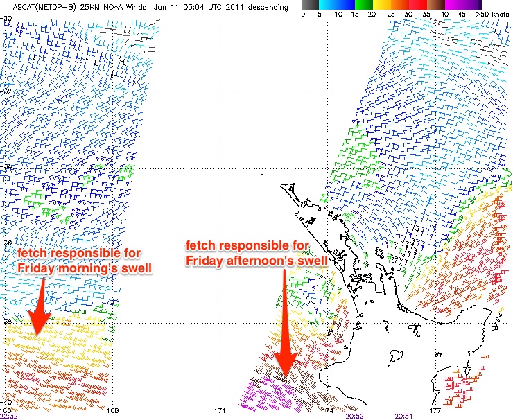
Friday is still shaping up to be quite a dynamic surf day. The morning will see a mix of swells from the SE and E/SE; the former fading from Thursday but the latter being some new energy from a fresh fetch that developed within a broad trough off the West Coast of New Zealand yesterday.
In fact, this source has produced two seperate fetches that have generated two individual pulses that’ll arrive during the day. The initial E/SE energy will arrive overnight on Thursday and should be worthy of inconsistent 3ft sets at open beaches for Friday morning. However a stronger, long period E/SE swell will arrive around lunchtime, generated by the primary E’ly fetch which was picked up by the ASCAT satellite this morning displaying a healthy 40kts (see image below). In fact, this fetch is still strengthening and broadening, and should reach full maturity this afternoon. This swell is expected to show most prominently from about early afternoon onwards.
However, model guidance has slightly pulled back expectations for this system, mainly due to a minor downgrading of the strength of the fetch, its width and also its westerly trajectory. This may also affect the consistency of the swell (which was already expected to be somewhat inconsistent anyway). As such, I’m going to pull slightly back wave height expectations for this swell to 4-5ft+ across most open beaches, with an outside chance for a handful of 6ft bombs at exposed swell magnets in the few hours before dusk.
Winds are looking generally good for most of Friday, light to moderate NW tending N’ly during the day but probably without any major strength into the afternoon (maybe 10-15kts worst case scenario). Exposed southern ends and offshore reefs may pick up a few wobbles into the afternoon but northern corners and the Hunter region should remain generally clean for much of the day.
This weekend (June 14/15)
Friday’s strong E/SE swell will ease steadily throughout Saturday. Early morning should see occasional 3-5ft sets at most open beaches (again, upper end of this size range more likely in the Hunter), but by late morning it’ll probably be down into a less consistent 3ft range with slightly smaller surf by late afternoon. Conditions should be good with light variable winds tending W’ly during the morning and freshening into the afternoon.
The new low pressure system expected to develop off the South Coast this weekend has been pulled back in size, scope and also timing. We’re still looking at a large south swell however the peak is now expected to occur on Monday. There’s still a chance for a strong increase late Sunday afternoon out of the south, but based on the existing model guidance, the most likely trend for Sunday will be a small easing E/SE swell with strengthening W/SW winds.
Next week (June 16-20)
The weather system developing off the coast this weekend looks to be a fairly routine winter Tasman Low, which is likely to translate to a large windy south swell on Monday, easing steadily from Tuesday onwards with abating offshore winds. At its peak, set waves should reach 6ft at south facing beaches and current expectations are for fresh SW winds tending W'ly during the day and easing (expect much smaller surf away from exposed locations). Tuesday and even Wednesday should produce fun clean waves off the backside of this event with moderate W/SW winds keeping conditions clean at most beaches.
Looking further ahead and there’s nothing significant on the charts beyond the middle of next week at this stage, but I’ll take a closer look at this on Friday.
Comments
G'day Ben. I'm interested in this comment (we do read this stuff yknow!):
"However, model guidance has slightly pulled back expectations for this system, mainly due to a minor downgrading of the strength of the fetch, its width and also its westerly trajectory. "
Does a westerly facing fetch encounter more energy losses than an easterly facing fetch, perhaps due to the corollisis effect?
40 knots x 36 hrs x 500Nm = 15 sec period swell trains, yes?
What say ye?
"Does a westerly facing fetch encounter more energy losses than an easterly facing fetch, perhaps due to the corollisis effect?"
Not that I'm aware of. Depends on the specific synoptic setup of each however in this case previous model runs seemed to have a slightly better westerly push within the fetch. Otherwise the overall fetch shape seems to have been pulled in a little too, compared to what was modeled on Monday.
As for the period calculation - that's about right, maybe a little lower near 14 seconds (although funnily enough, it doesn't match a swell nomograms).
Rusty , I haven't been looking at these forecasts , but I would say that sentence and in particular " the westerly trajectory " would most likely refer to the extent ( how far to the west it reaches ) . Which is actually a reference to the easterly fetch !
And if not perhaps , a retro grade ( westward movement ) of the entire system which might now be less . Retro grades help build a " captured fetch " . [ which is where a building swell is continually acted / upon built by the initial system .
Ah just saw your post. Spot on!
ben do you think it will be bigger gong/ulladulla area this weekend? ta mate
Bigger further north (if you're choosing between those two locations, that is).
Thanks Ben. And Southy!
dreaming !
.... about what?
A few decent sets pushing into Newy now. This is an easy 4-5ft, maybe bigger.
2ft max
C'mon Laird, it's a little bigger than that. Here's a zoom of the third image above (which was not the biggest wave of that set).
got a suggestion...forecasters should be objective...just giving facts. subjective is unscientific. eg., i love messy onshore days...some don't.
that's 2ft
you know it !
Its a tough one Ben. Image is taken from above...waves always look bigger. 4ft maybe? Is this swell ahead of schedule?
The swell is running a little late Don. Having watched the Newy cam every day for the last 18 months since it was installed, I'm pretty confident on the size. Sydney isn't as big yet (seen lots of sets in the 3ft+ range, but it's slow and inco) but Newy is really thumping through.
One other problem - we're close to the winter solstice. This swell was forecast to arrive "around lunchtime" - and because it's running a few hours late (and is expected to peak overnight) - it means the window of opportunity to surf is much, much narrower.
Were we close to the summer solstice, there'd still be three hours of surfable light left, and plenty of time to capitalise on the (still building) swell.
Gawd, for a troll you're rather boring WG.
WG loves giving the head job, just ask him...?
Maybe WG should hang out under the bridge with......?
As a complete aside, why is it when I click the "Surf Forecast" tab at the top of this page, it takes me to the Sunshine Coast Surf Forecast? Meh?
That's because it's the last surf report you looked at. it's a small coding error that's on the list of 'to-do' things (most of the time, people access the forecaster notes from the forecast page, so it all works fine).
Hmmmmm, I don't think the SC was the last forecast I looked at, but nevermind.
Great waves most days
Excellent waves expected later this week
Windy weekend of waves, with great surf for the longer term
all the above are subjective. my forecast heading would read...3 - 5ft for Sydney to Hunter region on Monday Tuesday Wednesday.Winds are what they they are. You try to specific
WG, they're called headlines. Call 'em clickbait if you must - the idea is to get people to read the forecast. However, we punch out hundreds of articles every month (forecasts, stories, galleries, videos, reports), and these kinds of descriptions help to individualise each content piece.
As for "Great waves most days" (Wednesday's headline), that's certainly been the case for the last two days and will also be the case over the weekend. So it's spot on as far as I'm concerned.
As for "Great waves most days" (Wednesday's headline), that's certainly been the case for the last two days..not in Sydney
WG no idea where u been surfing in sydney but the forecast has been spot on all week except maybe for today's morning report. But who gets it right 100% of the time. Ben keep up the awesome work on the site much appreciative, don't listen to this guys negative bs