Fun this week besides Wednesday

Southern Tasmanian Forecast by Craig Brokensha (issued Monday June 30th)
Best Days: Tomorrow, Thursday, Friday, Saturday
Features of the Forecast (tl;dr)
- Moderate sized, inconsistent SW groundswell building tomorrow PM, with a secondary stronger increased Wed, easing Thu
- N/NW tending variable then late S tomorrow
- Freshening S/SW winds Wed
- Variable W/NW winds Thu
- Moderate sized S/SW swell Fri, easing Sat with N/NW winds both days
Recap
Saturday saw building levels of groundswell under favourable winds (2-3ft morning), average yesterday as a trough brought an onshore change.
Today conditions are clean again with a reinforcing swell maintaining 2-3ft sets with conditions remaining clean into this afternoon.
This week and weekend (Jul 1 - 6)
We’ve got a great week of surf ahead thanks to a constant stream of polar frontal activity through our south-western and southern swell windows, with the strongest activity seen through the weekend at a little distance, ahead of weaker, but closer activity to us this week.
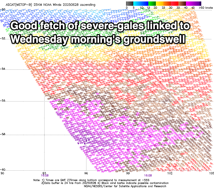
The distant activity has generated two separate pulses of SW groundswell tomorrow and Wednesday, with a pre-frontal fetch of W/NW-NW gales followed by stronger, severe-gale W’ly winds.
Two, back to back pulses of moderate sized groundswell are due, with the first arriving through tomorrow afternoon, pulsing to 3ft on the sets, with Wednesday’s coming in more to 3ft+, easing Thursday.
A solid sized, reinforcing pulse of mid-period S/SW swell is then due Friday, generated by a less favourably aligned, weaker but decent fetch of strong W/NW winds south-west of us on Wednesday.
Surf to 2-3ft is again due Friday, easing Saturday from 2ft+ or so.

Local winds this period look decent with a N/NW tending variable breeze tomorrow ahead of a late, shallow S’ly change. This change will bring freshening S/SW winds Wednesday, feeding into an intense low off the East Coast, with Thursday coming in cleaner under variable W/NW tending light E/NE winds.
Friday should see persistent N/NW winds, similar Saturday as the size eases.
Besides a small, long-range W/SW groundswell for later Sunday/Monday, next week looks slow until later week when we may see a strong frontal progression moving in from the west. More on this in the coming updates.