Small to tiny west swells this period

Southern Tasmanian Forecast by Craig Brokensha (issued Monday May 16th)
Best Days: Selected spots later Saturday and Sunday morning
Features of the Forecast (tl;dr)
- Tiny, inconsistent W'ly groundswell tomorrow, fading Wed with a W windswell in the mix
- NW tending W/SW winds tomorrow PM
- Strong W/NW tending W/SW winds Wed
- Tiny Thu with N/NW tending N/NE winds
- Small, inconsistent W/SW groundswell for later Sat/Sun with strong N/NE winds
Recap
The weekend saw generally tiny surf with fading 1-1.5ft waves Saturday, tiny yesterday.
Today the surf has remained tiny and early wind affected conditions have now cleaned up into this afternoon.
This week and weekend (Jun 17 - 22)
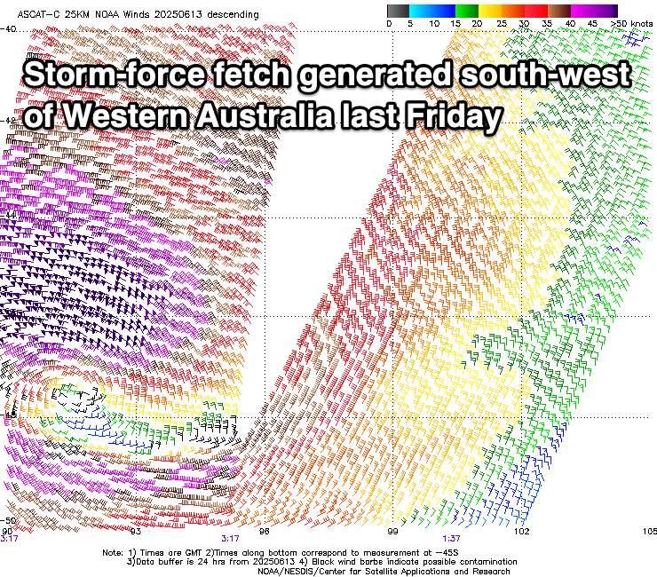
As touched on last week, a tiny W’ly groundswell is due tomorrow, with the source being located too far north and west of us to bring any major size. In saying this, storm-force winds were recorded around the low linked to the swell (south-west of Western Australia), and with this we may see 1-1.5ft sets tomorrow, fading Wednesday.
Local winds look NW through the morning, shifting W/SW into the afternoon and freshening as the remnants of the low moves across us, with strong W/NW-W/SW winds Wednesday but tiny, windswelly surf to 1-1.5ft.
Later Saturday and Sunday are our next best hope for a small, inconsistent increase in W/SW groundswell, with a strong polar frontal progression currently pushing up and across the Heard Island region, generating fetches of gale to severe-gale W/SW winds.

A final, stalling fetch of severe-gale W/SW winds east of the Heard Island region this evening and early tomorrow should help produce an inconsistent 1-2ft of W/SW groundswell for later Saturday and Sunday morning, though strengthening N/NE winds may create a few issues.
Longer term, all the activity focussing towards Western Australia might move our way later next week, but check back here Wednesday for the latest.