Fun swells for the coming days, more active next week

Southern Tasmanian Forecast by Craig Brokensha (issued Wednesday April 30th)
Best Days: Friday, Saturday, Tuesday, Wednesday
Features of the Forecast (tl;dr)
- Tiny tomorrow with N/NW tending W winds
- Small mid-period SW swell Fri with a stronger groundswell Sat AM, easing steadily
- N/NW tending variable winds Fri, moderate N/NW tending N/NE Sat
- Freshening N tending N/NW winds Sun with tiny surf
- Inconsistent W/SW groundswell possibly showing later Mon, peaking Tue with NW-W/NW winds
- Possible moderate sized W/SW swell mid-late week
Recap
The surf was poor and onshore yesterday while this morning we’ve seen cleaner conditions with a mix of swells in the 2ft range.
This week and next (May 1 - 9)
The current mix of swells are due to ease into tomorrow and with this we’ll see tiny surf across the South Arm under N/NW tending W winds.
Into Friday, our new pulse of mid-period SW swell is due to fill in, generated by a great, pre-frontal fetch of W/NW gales developing south-west of us this evening. The frontal system will actually deepen into a stronger polar low and with this a fetch of better aligned, severe-gale W’ly winds are due.

This should produce a stronger SW groundswell for early Saturday, easing steadily through the day.
Size wise Friday looks 2ft with Saturday morning coming in at a better 3ft, easing through the day and then down from a tiny 1-1.5ft Sunday.
Local winds look great with N/NW tending variable winds Friday, N/NW tending N/NE on Saturday and then freshening N tending N/NE winds Sun.
Monday will remain tiny, but into the late afternoon but more so Tuesday, a new inconsistent W/SW groundswell is due.
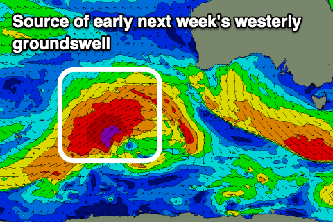
The source is a strong polar frontal progression projecting towards Western Australia later this week, under the influence of a strong node of the Long Wave Trough. A great but distant fetch of severe-gale to storm-force W/SW-SW winds are due to be generated through our far western swell window.
The swell from this source will be inconsistent with Tuesday likely to come in at an inconsistent 2ft under W/NW-NW winds.
We'll likely see secondary frontal systems bringing some additional, larger W/SW swell mid-late week but the models diverge regarding this. Check back here on Friday for an update on what looks to be an active week of surf next week.