Upgrade of the weekend's swell

Southern Tasmanian Forecast by Craig Brokensha (issued Friday April 25th)
Best Days: Tomorrow, Sunday
Features of the Forecast (tl;dr)
- Mix of W/SW and stronger SW groundswell building tomorrow, peaking in the PM, easing Sun
- Variable winds tomorrow, NW tending variable then late SW Sun
- New mid-period SW swell Mon with early S/SE tending variable winds then back S/SE again
- Strong S/SW winds Tue with a building windswell, easing Sun with possible lingering SW winds
Recap
The surf has hung around the 2ft range yesterday and today with some new W/SW groundswell filling in and conditions have been generally favourable as well.
This weekend and next week (Apr 26 - May 2)
We’ve got an upgrade in the swell due over the weekend, with our initial W/SW pulse for tomorrow morning on track, though the frontal system linked to a reinforcing pulse through the day coming in much stronger.
This is thanks to the front forming into a strong low as it passes under us this evening, with a great fetch of severe-gale W/SW winds generated through our souh-western swell window.
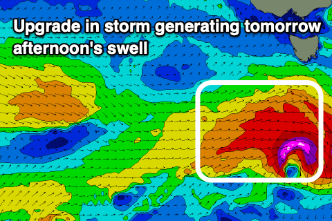
This should produce a strong kick in size tomorrow afternoon to 3-4ft, with the morning likely to be around 2ft to possibly 3ft.
Winds look variable most of the day tomorrow, creating good conditions, with easing surf from the 3ft range Sunday under NW tending variable winds and then a late SW change.
The change will be linked to another weaker frontal system passing under us Sunday, with it due to bring a pulse of new mid-period SW swell Monday to 2ft+ or so.
Winds might linger out of the S/SE on Monday morning, though become more variable through the morning before sea breezes kick in, with Tuesday seeing stronger S/SW winds as a weakening polar front pushes up and across us.
No major swell is due off this polar front and SW-S/SW winds look to linger Wednesday as it eases.
Longer term, a strengthening mid-latitude frontal progression later next week looks to generate some new W/SW swell into the following week, but more on this Monday. Have a great weekend!