Fading swells on the weekend, strong Tuesday

Southern Tasmanian forecast by Craig Brokensha (issued Friday April 18th)
Best Days: Tomorrow morning, Wednesday morning
Features of the Forecast (tl;dr)
- Easing W/SW swell on the weekend with a N/NW offshore ahead of S/SE sea breezes
- Tiny Sun with N tending E/NE winds
- Moderate sized SW groundswell building strongly Tue, peaking in the PM, easing Wed
- W/SW-S/SW winds Tue, possibly W for a period at dawn
- N tending E/NE winds Wed
Recap
There’s been a small, fun wave across the coast the last two days with morning offshores and weak sea breezes.
This weekend and next week (Apr 19 - 25)
The current swell is due to ease into the weekend, with small 1-2ft waves tomorrow under a light offshore wind before S/SE sea breezes kick in.
Sunday looks tiny and clean again ahead of E/NE sea breezes.
Now, moving into next week, and our inconsistent, long-range W/SW groundswell due for Tuesday afternoon and Wednesday morning becomes obsolete in the presence of a stronger, close-range swell producer over the weekend.
This will be a strong polar low with a pre-frontal fetch of gale to severe-gale NW winds due to be closely followed by tighter, severe-gale to storm-force W’ly winds.
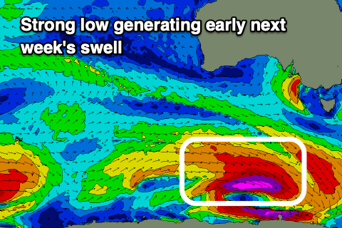
A moderate sized swell looks to be generated by this source, building strongly Tuesday and reaching 3ft to possibly 4ft across Clifton into the afternoon, easing from 3ft on Wednesday.
Local winds look dicey from Monday as a trough brings a S/SW change, possibly tending W/NW for a period early Tuesday before reverting back to the S/SW-SW through the day.
Wednesday is still the pick under variable offshore winds, tending E/NE into the afternoon.
Longer term the outlook is much quieter so make the most of the coming swell. Have a great weekend!