Poor winter outlook

Southern Tasmanian Surf Forecast by Craig Brokensha (issued Wednesday August 3rd)
Best Days: Next Monday morning
Features of the Forecast (tl;dr)
- Weak SE swell for Sun with fresh S/SE tending SE winds
- Easing SE swell Mon with N tending NE winds
Recap
A tiny start to yesterday with an afternoon increase in localised windswell, easing back today with tricky and unfavourable winds.
This week and weekend (Aug 4 - 7)
As talked about the last couple of updates, the outlook isn't favourable at all for swell generation inside the protected South Arm.
 A broad low with multiple embedded fronts rotating around it is now pushing east across Western Australia but too far north to generate any swell at all for the Arm.
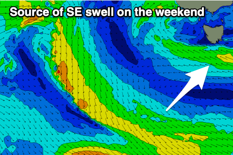
The only source of swell will be a surface trough moving in from the west on the weekend, directing strong E/SE-SE winds through our southern swell window.
This will produce a weak SE swell Sunday to 2ft to possibly 3ft but with onshore SE winds. Easing surf from 2ft is expected on Monday as winds improve thanks to the trough starting to clear our region. Light N'ly winds should be seen, tending NE through the day.
Longer term there's still nothing major on the charts for us but check back Friday for any changes.