Small swell building tomorrow

Southern Tasmanian Surf Forecast by Craig Brokensha (issued Monday August 1st)
Best Days: Tomorrow afternoon/evening, Wednesday morning selected spots
Features of the Forecast (tl;dr)
- Small W/SW windswell building tomorrow, peaking later with afternoon W/NW winds, shifting N/NW late
- Easing S/SW swell Wed with strong N/NE winds, easing and tending N/NW into the PM
- Weak E/SE windswell for Sun with SE winds
Recap
Good waves on Saturday with clean conditions and 2-3ft sets, backing off significantly to 1ft yesterday and tiny today.
This week and weekend (Aug 2 - 7)
The current forecast period is tricky regarding swell developments. In short a broad, slow moving low with multiple embedded fronts is moving into Western Australia but too far north of our prime swell window.
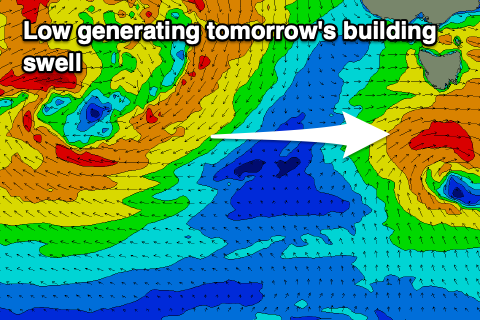 No decent swell is due from the multiple fronts pushing across Western Australia and through the Bight, but looking at tomorrow we should see a more localised increase in W/SW swell, shifting more S/SW while easing Wednesday.
This will be generated by a low forming south of us this evening, generating a fetch of strong to gale-force W/SW winds directly below us, with a little in feed of weaker S'ly winds on its tail.
An afternoon increase to 2ft is due tomorrow and with improving W/NW tending N/NW winds late afternoon.
The swell will ease on Wednesday from 1-1.5ft from the S/SW and with less favourable, strong N/NE winds ahead of another front. Winds should ease and shift N/NW later but the swell will be tiny.
Longer term there's nothing significant on the cards for the weekend other than some weak E/SE windswell from a trough forming south-east of us. More on this Wednesday and Friday.