Slow end to the week, very active next week

Southern Tasmania Surf Forecast by Craig Brokensha (issued Wednesday 15th September)
Best Days: Tomorrow morning and Friday for beginners, Saturday for the keen, Sunday for beginners, Wednesday, Thursday and Friday next week
Features of the Forecast (tl;dr)
- Easing SW swell tomorrow with N/NW tending S/SE winds, tiny Fri with strong N/NE winds
- Inconsistent W/SW groundswell Sat with N/NW winds
- Tiny W swell Sun with strong N/NE tending N/NW winds
- Good W/SW groundswell building late Mon, peaking Tue with some additional SW windswell along with strong W/SW-SW winds
- Easing mix of swells Wed with W/NW winds
- Large SW groundswell possible next Thu with NW winds
Recap
A fun mix of swells yesterday with S'ly energy being more evident, providing 2-3ft sets across Clifton. Today the swell has eased back from a small 1-2ft.
This week and next (Sep 16 - 24)
There's nothing major due into the end of the week swell wise, with tiny offerings for beginners across Clifton with 1-1.5ft sets tomorrow, 1ft on Friday. Conditions will be clean each morning, with a light N/NW tending S/SE breeze tomorrow and stronger N/NE winds on Friday.
We may see a very inconsistent W/SW groundswell Saturday, generated by a strong but distant polar frontal progression around the Heard Island region last weekend.
Infrequent sets to 1-2ft max are due, with persistent N/NW winds, shifting strong N/NE to N/NW on Sunday as a strong mid-latitude low pushes across us.
 The swell generating properties from this low look minimal, with a fetch of strong to gale-force W/NW-W winds firing up directly under us, possibly generating 1-1.5ft of swell for Sunday.
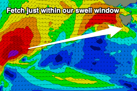
Of greater importance is a stronger low firing up on the tail of this initial system, generating a fetch of severe-gale to storm-force W/SW winds, just within our western swell window while under Western Australia Saturday.
This low will project east-northeast, north of our swell window before pushing in and across us Monday evening, bringing strong SW winds and a localised spike in windswell.
Coming back to the earlier stages of the low and this should produce a small to moderate sized W/SW groundswell for late Monday but more so Tuesday, coming in at 3ft or so, while the localised windswell looks similar in size.
 Unfortunately strong W/SW tending SW winds will create poor conditions on Tuesday in the wake of the low, back to the W/NW Wednesday as the swell eases from 2ft+.
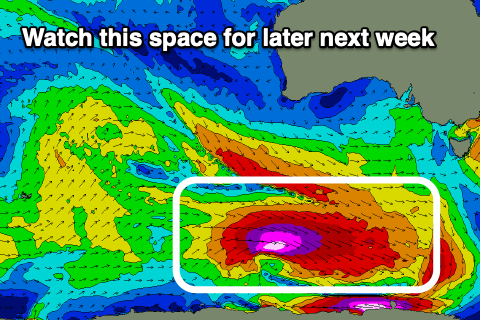
Following this we've got a more favourable polar low forecast to fire up along the polar shelf, south of Western Australia. Currently forecasts have this producing a significant fetch of severe-gale to storm-force W/NW tending W winds through our south-western swell window. The swell should arrive later Thursday and be moderate to large in size along with NW winds, but we'll have a closer look at this on Friday.