Good S/SE swell tomorrow

Southern Tasmanian Surf Forecast by Craig Brokensha (issued Monday September 13th)
Best Days: Tomorrow, Wednesday morning for the keen, Thursday morning, Saturday for beginners
Features of the Forecast (tl;dr)
- Easing W/SW groundswell tomorrow
- Good S/SE swell tomorrow with N/NW tending E/SE winds
- Easing S/SE swell Wed with a new pulse of SW groundswell but with light W/SW tending SE winds, easing Thu with N/NW tending SE winds
- Inconsistent W/SW groundswell Sat with N/NW winds
Recap
Friday afternoon’s strong increase in swell eased back through Saturday with great conditions and clean 2-3ft sets, becoming tiny into yesterday. Today a trough has brought with it onshore winds and poor conditions as a new W/SW groundswell fills in.
This week and weekend (Sep 14 - 19)
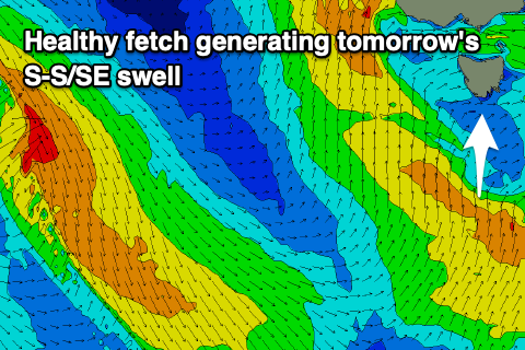 Looking at tomorrow, and we’re set to see a mix of easing W/SW groundswell from today and new S/SE swell, generated by a polar fetch of strong S’ly winds projecting up through our swell window yesterday.
Size wise, Clifton should see 3ft waves and with cleaner conditions as the trough clears, leaving light N/NW winds ahead of E/SE sea breezes.
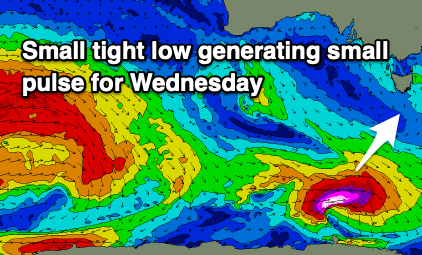
The S/SE swell will fade into Wednesday, though replaced by a strong new SW groundswell, generated by a strong polar low firing up south-west of us today. A quick fetch of severe-gale to storm-force W-W/NW gales tracking towards the polar shelf should generate a little spike to 2ft to possibly 3ft on Wednesday. Winds are a touch dicey though with light W/SW tending SE breezes more than likely across Clifton, adding some lump and bump to the swell.
 Thursday morning will be cleaner but the swell fading from a small 1-2ft.
Longer term there’s not much to rely on swell wise, with a very inconsistent W/SW groundswell due Saturday, though generated in our far swell window and unlikely to top 1ft to possibly 2ft.
Beyond this though we’ve got a much more active period ahead as a strong Southern Ocean frontal progression fires up under the country early next week, bringing plenty of action from Monday onwards. More on this in the coming updates.