Fun weekend ahead of a change Sunday

Southern Tasmania Surf Forecast by Craig Brokensha (issued Friday 10th September)
Best Days: Tomorrow morning, Sunday morning, Tuesday, Wednesday for beginners
Features of the Forecast (tl;dr)
- Easing mid-period SW swell tomorrow with strong N/NE tending NW winds, strong W'ly into the late afternoon
- Building W/SW swell Sun with early NW tending strong SW winds
- Peak in W/SW groundswell Mon with strong S/SW tending S winds
- New S/SE swell for Mon PM, easing Tue along with the W/SW groundswell. Light NW tending light SE winds
Recap
Wednesday's swell eased back temporarily into yesterday morning but conditions were clean and fun, with the swell kicking in size through the afternoon. Today there's plenty of swell on offer but not the best winds, with protected spots fairing best.
 This weekend and next week (Sep 11 - 17)
Today's mid-period swell energy will clean up into tomorrow but be easing back in size with fun 2ft+ waves due across Clifton tomorrow morning along with strong N/NE winds, favouring selected spots, shifting NW early afternoon with strong W winds late afternoon.
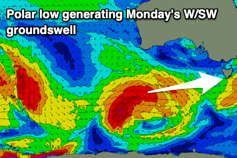
This will be as a weak trough moves in, with Sunday seeing the trough proper move through. Morning W/NW winds are due, shifting strong SW early afternoon. This will be as some new W/SW groundswell starts to show, with the peak in swell, generated by a strong polar low that's currently south-southwest of Western Australia, due to fill in Monday. But coming back to Sunday morning we should see a fun 1-2ft of swell ahead of the change.
 Monday's swell will be generated by a fetch of severe-gale W/SW-SW winds briefly projected through our western swell window today and tomorrow, with sets to an inconsistent 2-3ft due across Clifton. Unfortunately in the wake of Sunday's change, conditions will be poor with strong S/SW tending S winds. Tuesday looks cleaner with a light NW offshore and easing W/SW groundswell, mixed in with some small S/SE swell.
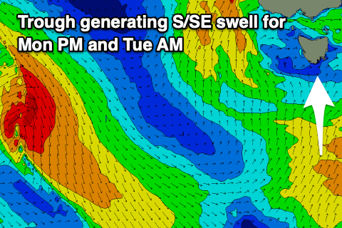
The source of the S/SE swell will be a polar trough projecting strong S'ly winds up through our southern swell window Sunday, with it filling in Monday and reaching 2-3ft into the afternoon, easing Tuesday from 2ft to possibly 3ft. Afternoon sea breezes look weak Tuesday so there should be a full, fun day of waves.
Longer term there's nothing too significant on the cards at all, so make the most of tomorrow, Sunday morning and Tuesday.