Upgrade in large swell

Southern Tasmania Surf Forecast by Craig Brokensha (issued Monday 6th September)
Best Days: Protected spots tomorrow, Wednesday, Thursday, protected spots Friday, Saturday
Features of the Forecast (tl;dr)
- Large W/SW tending SW groundswell building tomorrow with strong W/SW winds
- Steady drop in SW swell Wed with strengthening N/NW winds
- Building W/SW swell Thu PM with W/NW winds, peaking out of the SW Fri AM with W/SW winds, easing Sat with NW winds
- Another moderate sized swell for early next week
Recap
Fun, clean 2ft waves across Clifton both Saturday and Sunday, with a new W/SW groundswell filling in Saturday afternoon, easing while weakening to mid-period energy yesterday.
Today the swell isn't as clean with sloppy 2ft waves as a weak cold front pushes through.
This week and weekend (Sep 7 - 12)
Upgrade!
 We all love an upgrade and while the W/SW groundswell from the strong low firing up around the Heard Island region is on track for tomorrow, that's the lemon next to the pie.
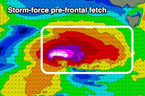
The low that was forecast to fire up on the pack of the initial polar low, generating a pre-frontal fetch of W/NW gales through our swell window today, is now due to be much more significant.
We're now due to see severe-gale to storm-force W/NW winds, followed by post-frontal severe-gale W/SW-SW winds in our south-western swell window this evening and tomorrow.
This is expected to generate a large, long-period SW groundswell for tomorrow, building through the day and peaking into the afternoon.
The morning looks to be 4ft or so and out of the W/SW, with the afternoon kicking to 6ft+ from a more SW direction along with strong W/SW winds.
 Winds are still expected to swing back to the N/NW on Wednesday, strengthening through the day with a rapid drop in SW swell from the 3-5ft range early, 2-3ft into the afternoon.
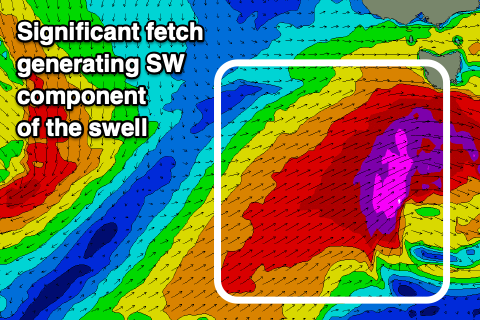
A temporary low point in swell is due Thursday morning, but into the afternoon and more so Friday, a good, new mid-period SW swell is due. This will be generated by a broad fetch of strong to gale-force W-SW winds firing up in our swell window Thursday, with the afternoon building to 2-3ft across Clifton, peaking Friday morning to 4ft.
Winds accordingly on Thursday afternoon look W/NW, with Friday seeing less favourable W/SW winds as the front pushes through. Saturday will be cleaner as the swell eases, and we then look at another significant swell for early next week. More on all of this Wednesday and Friday though.