Plenty of swell this period

Southern Tasmania Surf Forecast by Craig Brokensha (issued Friday 3rd September)
Best Days: Tomorrow morning, Sunday morning, Monday for beginners, Tuesday afternoon, Wednesday
Features of the Forecast (tl;dr)
- Low point in swell tomorrow AM ahead of a new W/SW groundswell into the PM, easing and more mid-period in nature Sun
- Light N/NW tending S'ly tomorrow, NW tending W/SW on Sun
- Moderate sized mix of W/SW groundswells building Tue PM with NW tending W/SW winds, easing Wed with fresh N/NW tending W/NW winds
Recap
Our stronger W/SW groundswell showed yesterday with strong N'ly winds favouring selected spots over others along with 2-3ft sets. Today the swell has dropped back to 2ft and a variable breeze is creating some slight lump/bump. It's still good for a surf though.
This weekend and next week (Sep 5 - 10)
Looking at tomorrow morning and we're expecting to fall in between swells with surf to 1-2ft.
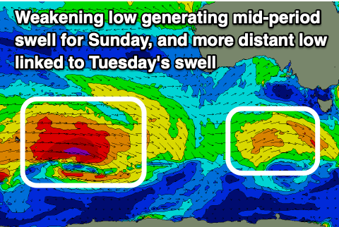 Conditions will be clean with a N/NW offshore but a trough will bring a S'ly change after lunch, just when some new W/SW groundswell is due to fill in. The source of this was a strong polar frontal progression projecting north-east towards Western Australia over the past couple of days, with the remnants of this storm now weakening south-west of us.
The groundswell should build to 2ft tomorrow afternoon but with that onshore wind, with the mid-period energy easing from 2ft along with a light NW offshore. Another shallow, W/SW change is due mid-late morning so surf early for the best conditions.
We then look at the strong polar low that's fired up in the Heard Island region today, generating a great fetch of severe-gale W-W/NW winds while pushing east towards us over the coming days. It'll slowly weaken on approach, but a secondary strong front is due to fire up on its tail, generating an additional increase in size when both swells arrive Tuesday.
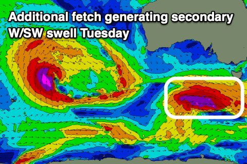 We're looking at moderate to large W/SW groundswell energy, arriving Tuesday morning and building to the 4ft+ range into the afternoon, then easing from 3-4ft Wednesday.
Winds will be best for protected spots with a NW tending W/SW breeze on Tuesday, fresher N/NW tending W/NW on Wednesday as the swell eases.
Following this we may see another broad, strong polar low firing up south-west of us mid-late week, but more on this Monday. Have a great weekend!