Slow increase in size from Wednesday

Southern Tasmania Surf Forecast by Craig Brokensha (issued Monday 30th August)
Best Days: Beginners tomorrow morning, Wednesday, Thursday, Friday morning, Sunday morning
Features of the Forecast (tl;dr)
- Tiny W/SW swell fading tomorrow with strong N/NE teding N winds
- Inconsistent W/SW swell slowly building Wed with moderate N tending NE winds
- Stronger W/SW groundswell Thu with strong N/NE winds
- Easing W/SW swell Fri with N'ly winds, tending light SW mid-afternoon
- Inconsistent W/SW groundswell building Sat PM with W/NW tending strong SW winds, easing Sun with N/NW winds
Recap
The swell tracked as forecast on the weekend, with clean, fun 1-2ft leftovers for the keen Saturday morning, tiny Sunday and best for beginners.
Today a tiny W/SW swell has kept tiny 1ft waves hitting the coast, ideal for beginnes.
This week and weekend (Aug 31 – Sep 5)
We've got similar conditions due across the Arm tomorrow, with beginners likely to find 1ft peelers under a strong N/NE tending N breeze. The swell will likely ease through the day so get in before lunch.
 We then look at the tricky W/SW groundswell due off a strong frontal progression that's currently moving in from the west.
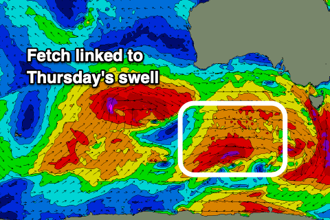
At the base of this progression, just within our swell window, a great fetch of strong to gale-force W/SW winds are being generated. We'll see this weaken initially as the progression pushes east this evening, but tomorrow morning a little intensification south of the Bight should produce a good, final burst of W/SW gales before the progression dips south-east towards the polar shelf.
We should see an inconsistent but fun W/SW groundswell emanating from this progression, arriving Wednesday afternoon but peaking Thursday morning. At this stage Wednesday morning looks 1-2ft max, possibly reaching a more consistent 2ft later in the day, but Thursday looks the best with 2ft to possibly 3ft sets across Clifton.
Winds on Wednesday will be favourable with a moderate N'ly tending NE breeze, stronger N/NE on Thursday, favouring selected breaks. The swell looks to ease Friday from 2ft with a N'ly offshore ahead of a shallow, mid-afternoon SW change.
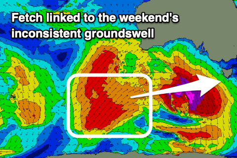 A temporary low point in swell is due Saturday morning, but a new, inconsistent W/SW groundswell is due into the afternoon, generated by a final polar front generating SW gales in our far swell window before projecting north into Western Australia during the middle of the week.
Winds look dicey with this new swell but, W/NW in the morning but then shifting stronger SW into the afternoon when sets push 2ft, cleaner Sunday but fading from 1-2ft.
Longer term there's hints of stronger polar frontal activity firing up under us next week, but more on this Wednesday.