Easing south-east, with swell to follow from the west

Southern Tasmania Surf Forecast by Craig Brokensha (issued Wednesday 30th September)
Best Days: Thursday, Friday, Saturday morning, Tuesday
Recap
Fun, easing 2-3ft sets yesterday, while a strong new S/SE groundswell has filled in today with solid close-outs across Clifton, better at other locations.
This week and weekend (Oct 1 - 4)
Today's strong S/SE groundswell is due to ease tomorrow and winds will shift W/NW as a strong mid-latitude front pushes across us. This will favour locations down the South Arm more exposed to the swell, with easing 2ft+ sets across Clifton.
This front doesn't look great for swell generation with a fetch of strong to gale-force W/NW winds dipping south-east through our swell window. We may see a 1-2ft wave into the afternoon, fading Friday.
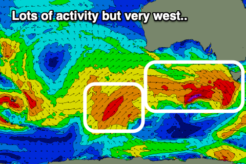 Some new W'ly groundswell is due to take its place on Friday though, produced by a stronger but also unfavourably dipping mid-latitude front through our swell window.
The back side of the front looks best with a more zonal W'ly fetch, but again this swell will be very west, with it due to build later Friday and reach 2ft or so (a bit smaller and to 1-2ft in the morning), easing from a similar size Saturday morning.
Winds should remain favourable and N/NW tending variable on Friday, with variable winds Saturday morning ahead of a S/SE change.
Sunday may unfortunately see lingering E/SE winds in the morning but we'll have to review this on Friday.
Some new, inconsistent W/SW swell is likely on Sunday though, generated by a slow moving and distant front producing a fetch of weakening W/SW gales. Size wise it doesn't look to top 1-2ft.
Longer term a stronger polar storm developing in our south-western swell window may generate some good new swell next Tuesday, but more on this Friday.