Tiny week, more potential from the weekend

Southern Tasmania Surf Forecast by Craig Brokensha (issued Monday 7th September)
Best Days: Early Saturday morning, Sunday
Recap
Tiny peelers on the weekend, cleanest Sunday while today it's back to knee-high stuff.
This week and weekend (Sep 8 - 13)
Looking at the coming week and unfortunately the frontal system that was expected to strengthen under us over the coming days isn't on the cards anymore.
Also the long-period swell showing on the charts was generated too north of us and in our far western swell window, with the models incorrectly combining this energy with a weak W/SW windswell.
Size wise we're now only due to see tiny 0.5-1ft waves tomorrow, similar Wednesday and fading Thursday. Winds will swing from N/NE to NW and then W/SW tomorrow, early W/NW Wednesday before shifting strong S/SW. N tending E/NE winds are then expected on Thursday.
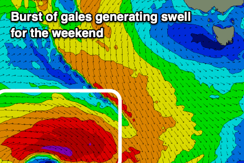 Into the weekend there are a couple of new, flukey swells sources on the cards. The first being a polar fetch of short-lived W'ly gales south of WA on Wednesday evening and Thursday morning. The swell from this source is due Saturday and out of the SW, providing 2ft+ surf.
A secondary source also for Saturday will be a rapidly deepening but also south-east tracking low, with a burst of severe-gale W'ly winds directed just within our swell window.
The swell from this source is due later Saturday, easing Sunday but it doesn't look to get above 2ft+.
Locally winds look favourable and N/NW ahead of S/SE sea breezes Saturday, N/NW tending W/NW on Sunday.
Longer term the outlook is much more active with a stronger polar frontal progression forecast to move in from the west on the weekend and early next week. This should bring larger and more consistent swell to the state, but more on this Wednesday.