Active period from early next week

Southern Tasmania Surf Forecast by Craig Brokensha (issued Friday 3rd April)
Best Days: Tuesday morning, Wednesday morning
Recap
Not the cleanest conditions across Clifton yesterday with a drop in swell back to 1-2ft, similar today but cleaner.
This weekend and next week (Apr 4 - 10)
With a downgrade in the swell potential from the mid-latitude storm and polar fronts moving in from the west, we've now got an upgrade, with multiple swells from the SW-S/SW due from later Sunday but more so early next week.
A strong mid-latitude low that's currently north of our swell window will drop south-east and into our swell window tomorrow, with a tight fetch of S/SW gales due to be generated south-west of us, tending more SW and being better aimed tomorrow evening.
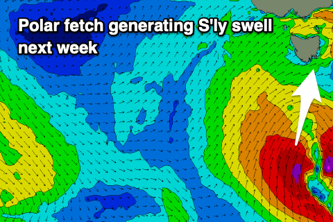 The low will then drift more polar and move slowly east while continuing to generate a fetch of S/SW gales right up and into us Sunday afternoon through Monday morning, then pushing off east.
What we'll see is a small increase in W/SW swell later Sunday, but more so Monday out of the SW, coming in at 2-3ft across Clifton, followed by a S/SW-S groundswell Tuesday providing bigger 3-4ft surf.
Looking at the local winds and W/SW breezes are due Sunday afternoon, W/NW just before dawn Monday but shifting strong W/SW at first light and SW into the afternoon as the low pushes east.
Tuesday should see a morning W/NW breeze, SW into the afternoon, similar Wednesday as the S'ly swell eases.
Therefore protected spots will be cleanest through this period.
Longer term a strong and significant node of the Long Wave Trough developing across New Zealand will project a series of strengthening polar fronts from under us into the Tasman Sea, producing plenty of swell from later in the week. More on this Monday though. Have a great weekend!