Couple of fun days ahead

South Arm Surf Forecast by Ben Matson (issued Friday 25th October)
Best Days: Sun: building S'ly swell though windy at times, tending cross-shore late a'noon as the swell reaches a peak. Mon/Tues AM: good winds (quite blustery Tues AM) with fun S'ly swells.
Recap: Tiny though clean surf has persisted over the last few days.
This weekend (Oct 26 - 27)
The publish time of these Forecaster Notes will be erratic this week, as Craig’s on annual leave. To receive an email when they go live, please edit your user settings here: www.swellnet.com/user
So, we’ve got a lot of swell and wind lining up on the weekend charts and graphs. But, the surf outlook it’s not quite as straightforward as you might otherwise think.
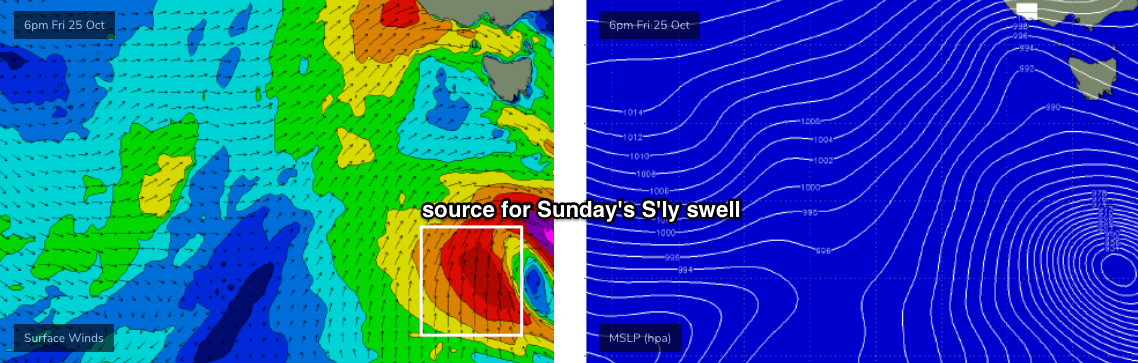
Right now a series of lows are either approaching Tasmanian longitudes, or starting to develop within our swell window. It’s all associated with an amplifying node of the Long Wave Trough. But unfortunately this hasn’t resulted in a favourable synoptic alignment - see chart below.
An approaching front in the Bight is currently riding too north in latitude to generate any swell for our region. We can effectively write this off as a swell source for the South Arm.
Additionally, an earlier incarnation of this low on Tuesday displayed 50kt W/SW winds, just SW of West Oz. This is the long period swell showing on the charts as arriving this afternoon (registering 18 seconds at Cape Sorell a few hours ago). However, the source fetch was again located too far north of our swell window to benefit the southern Tasmanian coast.
As such we’ll see tiny waves persisting into Saturday with gusty W’ly quadrant winds (early NW, then SW).
However, there is some swell on the way for Sunday. Unfortunately, there’s been a downgrade since Wednesday’s notes were issues, as the latest models have changed the way the responsible polar low evolves tonight and into Saturday.
It’s a real shame as this system looks unreal on paper in individual snapshots (see chart below), but it’ll rotate fairly quickly clockwise through the swell window, not spending enough time in any particular alignment to generate a large swell event.
Nevertheless, we’ll see building size into Sunday and most open beaches should reach an afternoon peak around 3ft (it’ll be smaller earlier). We’ll see clean conditions with morning NW winds but a mid-afternoon frontal passage will swing winds to the W/SW so this will likely provide average conditions as the swell reaches a peak late int he day. As such, keep your expectations low this weekend.
Next week (Oct 28 onwards)
Although it’s unfortunate that the low has been downgraded in size potential, there is some good news: it’s expected to linger a little longer in our remote south swell window, and should generate some useful S’ly swell for a few days early next week.
Another front approaching from the west will steer winds back to the NW Monday morning, and we should see fun 3ft surf throughout the day, persisting into Tuesday though we’ll see NW gales redevelop early Tuesday morning as yet another, even stronger cut-off low approaches from the west (delivering gale to storm force W’ly winds through the afternoon).
As such, make the most of Monday and early Tuesday as there should be some fun waves around the open beaches.
It’s also worth noting that early Monday will see the regional wave buoys lighting up with peak periods of 22+ seconds, signalling the leading edge of a very long range swell generated by a powerful solitary low in the southern Indian Ocean a few days ago.
Once again, this swell will have a lot of west in its direction and therefore we won’t see much size through the South Arm. Additionally, the enormous travel time will result in extremely long breaks between the waves. However we should see occasional 2ft+ sets from this source through Tuesday and Wednesday.
Looking beyond this, and the storm track looks subdued for the long term with no major swell events on the horizon.
Have a great weekend!