Small and average this week; potential options long term

South Arm Surf Forecast by Ben Matson (issued Monday 21st October)
Best Days: Tues/Wed: small flukey leftover swells with pockets of good conditions. Sun: strong S'ly swell, easing Mon.
Recap: Although the Cape Sorell buoy recorded very large wave heights over the weekend (with a S/SW swell direction), and very large surf reported through SA and Victoria, the swell direction appears to have been far too westerly to benefit the South Arm. As such surf size seems to have peaked around the 3ft mark. Wave heights are now trending down.
This week (Oct 22 - 25)
The publish time of these Forecaster Notes will be erratic this week, as Craig’s on annual leave. To receive an email when they go live, please edit your user settings here: www.swellnet.com/user
The next few days will see easing swells from today. A weak front will clip the coast overnight Tuesday so we’ll see freshening NW winds later Tuesday (light and variable early morning), tending W’ly into the early hours of Wednesday morning, becoming light into Wednesday afternoon.
As such, expect small patchy surf for the next few days.
During Wednesday, the regional wave buoys will pick up the leading edge of a long range groundswell, generated over the last few days from an unusually stationary sequence of lows out near Heard Island. It’s a real shame that this pattern was so far from Tasmania - and also quite north in latitude - as the swell will be of very high quality. Unfortunately, I fear the large travel distance and poor alignment will result in continuing small swells during the second half of this week as it reaches a plateau across the region into Thursday and Friday.
As a side note, a small polar low associated with Tuesday night’s was front may generate a minor pulse of S/SW swell on Thursday but again, I don’t think there’ll be much size in it.
Otherwise, Thursday and Friday will see strengthening winds as a deep cut-off low approaches form the west, albeit outside of our swell window. Winds will be N’ly Thursday and then W/NW Friday, at strength. So keep your expectations low.
This weekend (Oct 26 - 27)
The approaching cut-off low that will approach the state later this week will remain north of our swell window so I’m not expecting any swell from it.
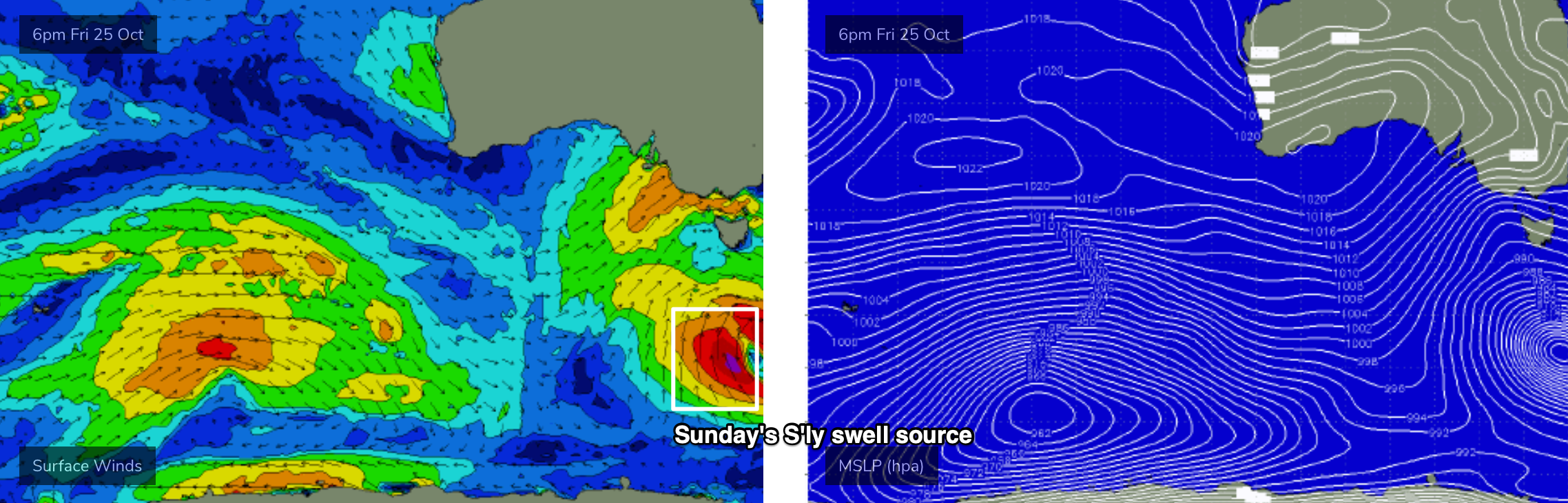
However, as the broader system moves over Tasmanian longitudes on Saturday, we’ll see a second deep polar low form well south of the state (see below) and this is lining up to generate a late S/SW swell for Sunday.
There’s a little more confidence on this swell that last weekend’s because of the better position within our swell window. Set waves could push 5-6ft at exposed spots, however winds will likely be fresh and gusty S/SW so this will focus the only surfable options to protected spots.
Let’s take a closer look on Wednesday.
Next week (Oct 28 onwards)
Sunday’s strong S’ly swell will ease through Monday, and behind this there’s a series of new swells for next week.
The models are showing some impressive long period energy arriving Monday, but this is being generated by a powerful low in the Indian Ocean this week that will be a little too far north of our swell window. However, it’ll undergo secondary developments between 90-110E along the ice shelf from Sunday into Monday and this should set up a good SW groundswell for the middle to latter part of next week.
More on this in Wednesday’s update.
Comments
Your notes are completely different to your model for Sunday
You have over estimated swell
Size more than once this year from forecaster notes
How sure are you on forecast of five to six Sunday because I don’t see it on the charts or the wave model
Let's see how things evolve, eh? If the forecast model graphs were 100% accurate, there'd be little need for the Forecaster Notes, wouldn't there?
Well either the forecast notes are wrong or your model is a bit of a joke the differences is fairly large for this Sunday’s forecast close to double
There is no major swell on the Indian Ocean wave model and the long term charts show no low to produce a large south swell so not sure watch you are looking at
Shane Abel; the only people who know how to forecast surf for Southern Tasmania are - Southern Tasmanians. Period