Plenty of swell and wind for this week

Southern Tasmania Surf Forecast by Craig Brokensha (issued Monday 19th August)
Best Days: Every day this week working the winds
Recap
Good waves for beginners all weekend, though best Saturday with the most size, while today we've got a new strong W/SW groundswell filling in though with average winds.
Today’s Forecaster Notes are brought to you by Rip Curl
This week and weekend (Aug 20 – 25)
We've got an active period of surf ahead but also with plenty of wind. Today's W/SW groundswell (mixed in with windswelly W/SW-SW swell) will ease through today, but a strengthening mid-latitude front pushing in from the west will steady wave heights and produce a larger increase in W/SW groundswell Wednesday.
It looks like tomorrow will see surf to 2-3ft, while a fetch of severe-gale W/SW winds moving under us Tuesday evening and Wednesday morning will generate Wednesday's larger W/SW groundswell.
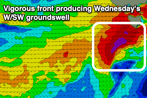 As the front continues moving east it will change its track slightly and project a little more north-east, resulting in the swell shifting more SW later Wednesday and more so into Thursday before easing later in the day.
Size wise, Wednesday looks to offer surf to 4-5ft out of the W/SW, shifting in direction later, and then easing from 4-5ft or so on Thursday morning out of the SW.
Winds tomorrow will be favourable and out of the W/NW all day, though stronger into the afternoon and then gusty out of the W/SW on Wednesday, strong and poor from the SW Thursday.
Friday looks excellent as the SW groundswell continues to ease from Thursday afternoon from 2-3ft with N/NW tending N/NE offshores.
The outlook for the weekend is a little tricky as the models diverge on the strength and track of a polar front moving in from the south-west. GFS has a stronger and better aligned low, while EC is weaker and not great for swell production. Therefore we'll have to have a closer look at the weekend's outlook on Wednesday.
Comments
Why is your model forecast higher than your notes this seems to be a consisten problem with your model
Southern Tas has a lot of windswell contamination issues when the storm track is vigorous and in the near vicinity.
I think you'll find that most models struggle with this pattern too.
When the storms are so close to the location in question, the models can't resolve the different groundswell and windswell components for the virtual buoy point. This isn't just an issue for us, but all model forecasts and sites. We've made adjustments to the algorithm that works with this data to dampen the swell forecast but it's a balance of going too far and then under forecasting the smaller swells.
Thanks for the response