Large swells with less than ideal winds

Southern Tasmania Surf Forecast by Craig Brokensha (issued Friday 8th March)
Best Days: Saturday morning, dawn Sunday, Tuesday morning, Thursday morning
Recap
Good clean and easing swell yesterday, tiny this morning but a strong increase in new W/SW swell should be starting to fill in this afternoon.
Today’s Forecaster Notes are brought to you by Rip Curl
This week and weekend (Mar 9 - 14)
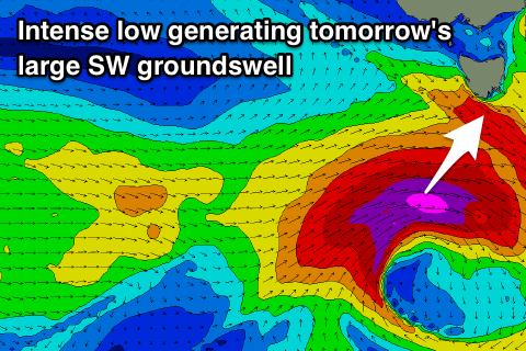
A deep and powerful low developed west-southwest of us yesterday and has generated a storm-force fetch of W/SW winds, moving more into our south-western swell window today while dipping south-east.
A large and powerful long-period W/SW tending SW groundswell should be seen, with the W/SW component building this afternoon, ahead of a peak in the SW groundswell component tomorrow morning.
 Unfortunately because the low is dipping south-east winds will be onshore and out of the SE (without too much strength), tending variable for a period ahead of sea breezes.
Clifton should see strong 3-4ft sets, easing steadily through the day, with Sunday coming in at a small to tiny and easing 1-2ft with a N/NW offshore ahead of a late W/SW change.
Moving into next week and a small inconsistent W/SW swell is due to build later Monday and peak Tuesday morning, generated by a distant polar front projecting east-northeast and just within our western swell window.
A small and inconsistent 1-2ft wave is due across Clifton Tuesday morning with a NW offshore ahead of a late morning W/SW change.
This change and a late increase in W/SW swell will be associated with a vigorous frontal progression moving in from the west, with it develop east of Heard Island tomorrow afternoon.
A fetch of severe-gale to storm-force W/SW winds will be projected through our far western swell window, with the progression tracking east-northeast and remaining just within our western swell window through Sunday and Monday.
A large long-period W/SW groundswell will be generated for our West Coast, with the swell coming in moderate in size across Clifton, peaking Wednesday morning.
We should see easy 3ft sets, if not for the odd 4ft'er, easing through the day but with an onshore SW wind owing to the front moving across us Tuesday. There may be a period of early W'ly winds but we'll review this Monday.
Longer term a small low moving in from the west, the remnants of Tropical Cyclone Haleh is due to generate a new swell late next week, but more on this next update. Have a great weekend!