Small to tiny weekend, better swell next week

Southern Tasmania Surf Forecast by Craig Brokensha (issued Friday 1st March)
Best Days: Saturday, Thursday
Recap
Tiny waves yesterday, similar this morning and sea breezes are now in.
Today’s Forecaster Notes are brought to you by Rip Curl
This weekend and next week (Mar 2 - 8)
Our small long-period SW groundswell due later today is expected to peak tomorrow morning to a fun 2ft across Clifton, easing into the afternoon and tiny Sunday again. The swell was generated by a good polar fetch of gale to severe-gale W/NW winds the last couple of days.
Conditions should be clean all day tomorrow with a N/NW tending N'ly breeze, clean Sunday morning ahead of an afternoon change.
 As touched on last update there's nothing significant on the cards early next week until we see a good long-period W/SW groundswell filling in Wednesday, easing Thursday.
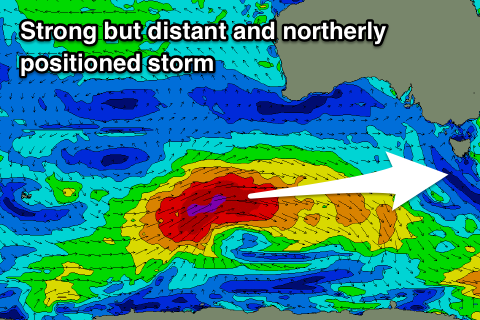
This will be generated by a strong and distant storm developing in the Heard Island region this evening, tracking east-southeast into our far western swell window on the weekend. A fetch of severe-gale to storm-force W'ly winds will be produced, with the storm expanding in scope while weakening slightly early next week.
We should see a good long-period but inconsistent and westerly W/SW groundswell for Wednesday next week, building through the day and reaching 2ft to occasionally 3ft. Unfortunately conditions will be bumpy as the swell peaks with an early W/NW offshore due to swing W/SW-SW mid-late morning.
Thursday looks clean again but the swell will be smaller and easing from 2ft+ or so.
A secondary weaker and poorly aligned low moving in mid-late week may generate a new swell later week and into Saturday but we'll review this Monday. Have a great weekend!