Small S/SW swell filling in Sunday, better swells next week

Southern Tasmania Surf Forecast by Craig Brokensha (issued Wednesday 17th December)
Best Days: Sunday mid-late morning. Tuesday afternoon, Wednesday morning, Thursday, Friday
Recap
Yesterday was tiny and average while today a new mix of swells due across the coast have come in at 2ft, but cleaner than expected with winds persisting from the W/NW for most of the day.
This week and weekend (Dec 16 - 21)
Today's spike in W/SW swells are expected to ease off overnight leaving tiny 1ft+ sets tomorrow morning. Conditions will be clean with offshore N/NW winds persisting most of the day before tending variable late.
Friday is expected to remain tiny and in the 1ft+ range as a weak W/SW swell from a front passing under us fails to generated any significant size.
Into the weekend we should see a slight kick in new S/SW swell through Sunday reaching 2ft on the sets across Clifton.
This should be generated by a small but strengthening low passing under us Saturday with a fetch of strong to gale-force S/SW winds being temporarily generating in our swell window.
The swell is due to build through Sunday and peak through the middle of the day. Winds look favourable with a N/NW offshore before SE sea breezes kick in.
 Next Monday onwards (Dec 20 onwards)
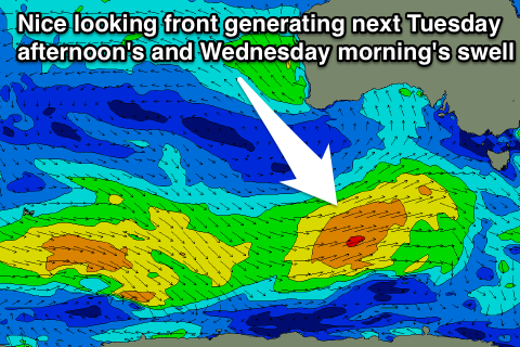
Sunday's small pulse in S/SW swell will drop rapidly overnight as a result of the low moving off quickly to the east. Some better W/SW groundswell pulses are due through next week and into the following weekend as a series of relatively weak but broad polar fronts push up towards us from the weekend onwards.
The first good increase is due through Tuesday afternoon to 2ft+, easing early Wednesday from 2ft to nearly 3ft under offshore winds.
Secondary pulses are then due Friday and Saturday to the 2ft range, but we'll review this again on Friday.