Stacks of sustained swell from the south, and a peak from the east

South-east Queensland and Northern NSW Surf Forecast by Ben Matson (issued Fri 16th Dec)
Forecast Summary (tl;dr)
- Large S'ly swells and fresh S'ly winds in Northern NSW peaking Sat, easing into Sun, much smaller through SE Qld
- Inconsistent E'ly swell Sat AM, easing from the a'noon onwards
- Renewal of strong S/SE swell on Mon (MNC) into Tues (Nthn Rivers/SE Qld) with continuing S'ly winds
- Gradual easing of swell and wind for the rest of the week
Recap
The E'ly swell's been a slow builder over the last few days, and as feared in Wednesday's notes, has performed better south of the border than in SE Qld. Still, size is now up into the 3ft range (4ft in NNSW) and there's a bigger S'ly swell building across Northern NSW under fresh southerly winds with 4-5ft+ sets.
This weekend (Dec 17 - 18)
Both swells are expected to peak tomorrow, with fresh S/SE winds confining the best waves to the southern points.
There's no evidence to suggests any deviation away from the current regional trend for the east swell, which is for smaller surf in SE Qld than in Northern NSW, and it's worth mentioning that the distant source of the energy means set waves will be inconsistent, which isn't useful for the well-populated points (they'll be the only locations handling conditions).
Size should reach 3-4ft from this source in SE Qld and 4-5ft in Northern NSW.
Elsewhere, we've got a strong south swell moving up the Northern NSW coast which delivered 8ft+ sets in Southern NSW late yesterday. We won't see quite this size across Northern NSW on Saturday, and exposed northern ends will be very wind affected, size pushing 5-6ft. Locations not exposed to the south will be much smaller.
SE Qld will see smaller size from the south swell due to the southerly direction; a wind affected 3ft+ at exposed northern ends and 2ft surf across semi-exposed points. This should however fill in the gaps from the inconsistent E'ly energy.
We'll see a continuation of similar winds on Sunday but with decreasing size from both sources.
Next week (Dec 19 onwards)
A firm ridge across the coast will maintain fresh southerly winds through into Monday and Tuesday, before easing on Wednesday.
Although the east swell will be well and truly on the way out by Monday, we have some new swell from the southern quadrant on the way.
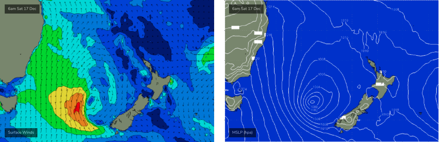
A reintensification of the Tasman Low on Saturday and Sunday - further east, near New Zealand (see below) - will generate a renewal of strong S/SE thru SE swell that will build across the Mid North Coast on Monday afternoon, reaching the Far North Coast overnight. Exposed locations should push a solid 6ft+ from this swell, though once again sheltered southern ends will be much smaller.
SE Qld should fare a little better from this swell (owing to the more eastern swell source) but size will still be somewhat restricted to exposed northern ends, which will be wind affected (they'll reach 4-5ft or so). Semi-exposed points should see a peak either late Monday or (more likely) Tuesday morning around the 3ft mark. However, swells with a lot of south in their direction often underperform across much of the SE Qld region so - despite the favourable wind outlook - keep your expectations lower than normal.
Wave heights will then ease slowly across Northern NSW through the rest of the week (4-6ft Tues, 3-5ft Wed, 3ft Thurs, 2-3ft Fri), with winds becoming light by Wednesday ahead of freshening N/NE winds from late Thursday through Friday.
SE Qld will see much smaller surf, and generally better conditions with a weaker synoptic flow. Thursday will probably be the pick for the open beaches with the best winds of the week for exposed locations.
The Xmas period looks small on the charts right now but there's a few signs that we'll see increasing tropical activity that could lead to some interesting developments - though models are quite divergent so there's no use speculating too much right now. Either way, it'll be very interesting to assess the model guidance on Monday.
Have a great weekend!
Comments
A pretty shit outlook for the GC. Too small for the points but too windy for the beachies. Sigh....next swell please!
Yep Rocket. Crap on the GC, tiny packed points and blown out beachies. Meh
Yep can confirm. Terrible.
crap from byron to ballina too lads
I found a bit of fun but was escorted from the water by a large (10ft+) tiger shark.
warm blue water has bought in the oceanic tigers.
He was in full cruise control mode but when he went past a second time I got out.
Me too. Lots of mullet coming through wide off Rainbow yesterday arvo, had a good size one charge straight at me and change direction last second. Scared the shit out of me and a Brazzo fella just inside me. Still cleaning out my boardies. Westpac chopper hovering over Greeny for a long time this morning too - be careful out there guys.
One cruised through kirra whilst I was there also. Helicopter above for quite some time also.
seriously a good sized shark at rainbow in cooly? been surfing there decades and never seen one
You do recall a guy was mauled to death by one at Greeny a few years ago?
One the dawn crew saw a big one at Alley this morning, he said “not today”
Yeah, another sighting this afternoon.
Probably on its way out to Palmy Reef. Did you see the footage of the bloke fishing from his kayak last week?
Very underwhelming swell on the GC. I’d say a combo of the swell quality, sand banks & wind combined made it very average.
I will note that Ben didn’t over hype at all. But also didn’t go into too much detail on winds etc like Freeride does really well so the report was open to interpretation
yeah I dunno, I would rather some swell with bad winds like we had today, than what we had early in the week (tiny tiny waves with no wind)... I found a quite a few fun waves of the rip bowls forming of the GC sandbars....