Extended E'ly swell event persists all week, with winds mostly favouring Points

South-east Queensland and Northern NSW Surf Forecast by Steve Shearer (issued Mon Jan10)
SEQLD/NENSW Forecast Summary (tl;dr)
- E to E/NE swell building in Tues with E/SE winds, more E'ly south of Yamba
- E swell muscling up Wed, likely peaking Thurs with SE winds, lighter Thurs AM
- Plenty more E swell Fri into Sat with light winds Fri, tending NE on Sat
- More E swell, rebuilding from the E/SE Sun, with N'ly winds, lighter in SEQLD
- E/SE swell Mon, slowly easing through Tues with N'ly winds, dropping out Tues
- Quieter period then ahead from mid next week, stay tuned for details
Recap
A few small waves over the weekend, a bit tattered by last weeks constant onshore flow, which persisted into Sat. Size was around the 2-3ft mark across most of the region with water quality and sand bars affected by the recent ran and large swells. Sunday saw more of the same messy 2-3ft surf with a mod E’ly to ENE’ly flow a little bit lighter than Sat. A few small 2footers were on offer at protected breaks. Size has dropped further into today with a weak 1-2ft signal from the E and light winds, now tending SE. Another round of E/NE to E’ly swell is on the menu this week with winds mostly favouring the Points. Reads on for details.

Small and weak with some nice beach formations, much more energy expected this week
This week (Jan 10-14)
Our current synoptic pattern is typical of the season and the La Nina end of the ENSO cycle. High pressure straddles New Zealand and a tropical low now drifting south from between Fiji and Vanuatu. A long E’ly fetch associated and strengthened by that combination will be the main swell source for the East Coast this week. The low is expected to slowly drift through the swell window, spraying the region with swell from the Eastern quadrant.
 Current ASCAT (satellite windspeed) passes show a long E’ly fetch of strong winds extending out to 165W, with stronger low end gale force winds located closer to the East Coast -roughly equidistant between Fiji and New Caledonia- and well aimed at SEQLD/NENSW.
A tropical cyclone off the North QLD coast (TC Tiffany) will not be a swell generator as it tracks inland to reform in the Gulf of Carpenteria, taking basically the reverse track of TC Seth.
Short term and we’ve only got one more quiet day surf-wise for the f/cast region.
Tuesday will see an increase in new E-E/NE swell generated by the South Pacific fetch. This swell will be nice and straight, and pulsey so good bathymetry is likely required to get good surf. From an under-sized start surf should build from 2-3ft into the 3-4ft range through tomorrow. Expect mod E/SE winds, which will tend more E’ly south of Yamba.
These winds will then clock around more SE on Wed and Thurs. There’s a chance of lighter S to SW winds inshore early, especially on Thurs and more likely on the Southern Gold Coast.
High quality E swell will build from the 3-4ft range Wed into the 3-5ft range Thurs. It’s not really a size to sort out crowds on the Points but that is definitely where the cleanest conditions will be under prevailing SE winds.
With the tropical low slowly tracking through the swell window, swell direction will by degree, track slighty from north of E to dead E. That won’t make much difference to most spots but it could light up certain spots.
Friday looks fantastic with light winds, tending SE in QLD, more E’ly south of the border, and surf holding in the 3-5ft range at exposed breaks, smaller at more sheltered Points.
This weekend (Jan 15 - 16)
Plenty of E’ly swell for Sat and Sunday with NE winds developing as the dominant high drifts over New Zealand and the ridge breaks down along the sub-tropical coast. With NE winds on the agenda likely to be mod/fresh you’ll have to tuck in behind south facing headlands to get some protection. There’s a good chance some marquee backbeaches will be pumping this weekend.
Size should hold in the 3-4ft range. A longer period pulse of more E to E/SE swell later Sun could see some bigger sets in the 4-5ft range after lunch.
One caveat for the weekend f/cast is if the low tracking southwards from the South Pacific to New Zealand stalls or changes direction we could get an upgrade or downgrade, depending on the speed and direction of movement. Best case is a stall near the North Island .
Next week (Jan 17 onwards)
In case you didn’t get a swing at it, next week begins with more of the same E to E/SE’ly swell. Models currently show a slight period kick later Sun- and even if we have to revise this later in the week- it’s a good sign that Mon will kick off with more of the same 3-4ft swell. N’ly winds persist Mon, lighter in SEQLD.
An approaching trough should track north Tues, bringing lighter E’ly winds. With E/SE’ly swell holding in the 3-4ft range.
Models diverge next week with EC showing a surface low forming E of Tas by the middle of next week, generating a S to SE swell from mid next week.
GFS sits the trough over the Sydney/Hunter coast, with SE winds aimed up into the region and generating short range SE swell.
With both models showing the next high pressure system located well to the south of Tasmania into the start of next week that is likely to see an onshore flow across the region, most likely from the SE through the middle to end of next week.
Tropical developments look more focussed on WA/NT after all the activity has been in our longitudes for the last fortnight.
Check back in on Wed and we’ll run the ruler over it again.
Comments
Hey Rocket I think your last report could use a reapplication.
It'd be grouse if there was a point break in Castaways/Marcus
grouse that’s Mexican talk : )
Bit of coffee rock nth of Eden on low tides the best you ll get. Beats shuttling into Noosa fwiw
Surf forecast - 11 Jan 2022
I hope you all found some waves in the last week, whether you had to drop in on someone or use your ski to ride them over.
2022 sure opened up its arsehole to swell but it was accompanied by gale force SE winds and extreme high fukin tides which left some poor bastards incl myself hunting around at those elusive spots hoping for a chance to get a surf in without too many crowds. All would have been good if it was not for the winds and the tides (which screwed up the banks).
So essentially I'm still dying for a proper surf and trying not to fall into the trap of actually expecting anything from the upcoming forecast.
While most people seem to pick the best of the forecast period, I recently seem to plan for the backend of it, when the swell is dying down, the winds are turning more miff, the conditions are generally becoming poor, hoping more people will be surfed out and skipping the "left overs".
Guess what, there seem to be a large group of vultures planning the same thing.
Oh well....there's always the wave pool in Melbourne to smash. Perhaps a surf trip there would yield better results in one single hour session compared to a week of hunting in QLD.
Anyway, looking ahead. Some more east swell on the way so many of us get to have a second chance and hunt down something, somewhere. Keep your ski's in the garage because no one wants to see you using your noisy piece of shit on a 4-6ft day at the points. That's right, swell is expected to peak late this week in the 4-6ft range (use your favourite windguru or magic seaweed site to find out more details) but essentially the winds still have their asshole open to the SE. It does however seem to look like some mornings might have a chance of lighter SW winds, opening up some beachie options for those who are like me and see this as the golden opportunity to get wet and not get ridden over.
But make sure you have your bottle of medical cannabis ready, because your are still more likely to get disappointment this week than joy. My recommendation is to wake up each morning at first light, check wind and go immediately should it be calm. Don't forget your THC.
My other secret is take 2 boards. Make sure one of them is a fish or groveller so that you can make the most of those shit conditions.
If you love speed bumps and party waves, go to your usual point breaks and you should be in for another treat this week you bunch of wankers.
So whether you're a hustler at the points this week or a crowd hater at the beachies, good luck out there!
See you next week for another update.
Toonalook Point forecast notes
A prick ran over me “accidentally” at cooly on the 2nd of Jan & nearly chopped my foot off. Missed all the swell & still have stitches……it could be worse
Edit: not going near those wanker crowds again
Tweaked my knee 9.00am NYE having a hit of tennis with the kids. Hopefully Thursday / Friday. Last time I be a good dad!
Honest advice, get yourself a Foamie, keep it in the car. Fool yourself into enjoying empty closeouts. Stay in shape in case the elements combine without the hoards. It could at least theoretically happen!
Good Work Rocket
Points starting to show the incoming swell. Pretty shitty and bumpy though so far
Today is the worst day of the week wind wise.
Copy that Craig. Def cleaning and straightening up as the day goes on
That swell muscled up and impressed this arvo. Blue bowls!
I had a surprising amount of fun out at the Pass, a little taste before the crowds get on it - still plenty of sand left after the last swell, should be pretty the next few days.
Can't say if it was fun or not, only got a couple but it looked like it. Just stoked to be out there after a long road back. Yew!
How come the Byron cam is still down while The Pass is working? Isn’t it just a wider angle on the same camera?
Should be fixed this arvo.
Definitely permanent.
short cut! or long cut, depending on where you are coming from ha
Wow, yeah looks there to stay.
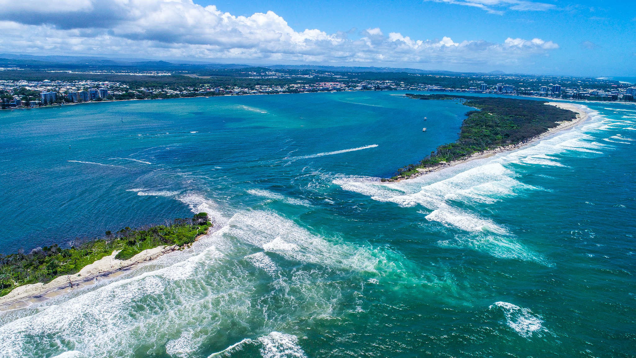
Where'd that photo come from, Sprout?
Sorry, yeah credit Zane Jones, more here: https://www.sunshinecoastnews.com.au/2022/01/12/bribie-island-pumiceston...
Cheers.
New Bribie Bar.
I was living at Alexandra Headland when the Maroochy River broke through the southern side of Pin Cushion in 2000 (possibly 2001).
The left running off it was amazing.
I wonder what the plan is re Golden Beach, when the Southport Seaway was constructed they built Wave Break Island to protect the for Labrador foreshore.
Pincusion broke through May 1999.
I was right into photography at the time and got some good slides of the day it broke.
Remember someone named that left "pindonesia" haha!
Had a good reminisce as I went through the old pics the other day.
I'd be happy to share them if I was computer savvy enough to get slides to digital, then figure out how to post a picture onto this website.
Spoke to some friends who live at Golden beach yesterday, and they said swell is definitely moving through the passage and hitting Golden Beach now.
Jeez there would be some Noah activity with that run out.
Wonder how much of the northern part will be left in 2 weeks time with the consistent east swell.
Fuck me, NBB (New Bribie Bar) looks like a left and a right set up... how good is SEQ at creating New waves.
Definetly wortha squiz over the next couple of days...
It's too deep and short leading in and off the corners like a shit reef, perhaps in time with the right sand movement though...
be interesting to see - noting long term sand buld up water flow will provide something though..
Those 4 apartment towers look like they are perfectly lined up with the bar. Could be some waves out the front soon.
Looking at the cam, the pass looks shit. Those nice banks have gone, that have been pritty good for about a year.
Yeah, surfed there this morning. Wasn't great.
Same. Outside was fat, little inside runners the only fun.
Yeah there's that sand slug now extending north-east out off the bank. Has lost its way a bit.
Pass bank has been exceptional for close to two years.
had to start to disintegrate sooner or later.
I guess it has been a couple of years. I seem to remember a large cyclonic swell a couple of years ago with big storm banks, and no sand at all through pass, then after that things improved and never really got bad.