Easing surf over the coming days; small pulse at the end of the week

South-east Queensland and Northern NSW Surf Forecast by Ben Matson (issued Monday Dec 13th)
Forecast Summary (tl;dr)
- Steadily easing S/SE swell Tues, bottoming out Wed/Thurs with small beachies
- Only small in SE Qld for the next few days; outside chance for a minor NE swell from TC Ruby (don't get your hopes up)
- Fresh S'ly winds Tues, becoming lighter through the rest of the week
- Fun small SE swell Fri and Sat, mainly in Northern NSW
- Trade swell on target for the Xmas period
Recap
The weekend delivered great waves across many regions. In particular, early Saturday offered a window of light morning winds and clean 3-4ft E’ly swells, with most regions delivering great options. Fresh southerly winds kicked in early/mid morning, pushing the best waves to the regional points from thereafter. Building southerly swells crept into the Mid North Coast on Saturday afternoon and remaining Northern NSW coasts on Sunday, around the 4-5ft mark, whilst the east swell persisted elsewhere around 3ft+. The east swell then eased overnight Sunday and into this morning, whilst the S’ly swell veered more S/SE across Northern NSW and maintained 4-5ft sets, under freshening southerly quadrant winds.
This week (Dec 14 - 17)
The Tasman Low responsible for our three-day swell event began easing late Sunday so we’ll see a corresponding easing of surf size from tonight onwards. However, southern NSW was still picking up 5-6ft sets this afternoon so we’ll still see plenty of juice in the tank across Northern NSW on Tuesday, probably in the 3-5ft range at south facing beaches, though wind affected under fresh southerly breezes.
Elsewhere, expect much smaller surf, including SE Qld where we’ll see very little southerly swell make its way north of the border (aside from exposed northern ends, and south swell magnets, which’ll be wind affected).
However, there is still a faint, glimmering hope for some small NE swell to make landfall during Tuesday, and into Wednesday, originating from TC Ruby.
I gotta say though, the model guidance isn’t promising.
Last week it was all over the shop, and today seems to have consolidated around an unrealistic peak in size and energy this morning, with 0.8m at 14.4 seconds, ahead of a slow decline through Tues and Wed. This isn’t really plausible given the timeline of the developing cyclone over the weekend, and the travel time required from the northern Coral Sea.
So, either the models have got this event partially wrong - by way of a delayed arrival time - and we’ll see some energy filter in on Tuesday afternoon, holding briefly into Wednesday morning (as mentioned in Friday’s notes). Or they’ve got it completely wrong, and we won’t see anything at all.
Either way, confidence ain’t high for this swell event.. I can’t see there being much more than a stray 2ft+ set at the outer swell magnets in SE Qld. Don’t pack the car in anticipation, that’s for sure.
Therefore, as the S/SE swell eases over the coming days, expect a small combo of residual swells in SE Qld, with Tuesday generally roughed up across the open beaches by moderate S/SW tending fresh S/SE winds. Outer points will be very small, but at least clean.
Lighter winds are then expected for the rest of the week with small beaches easing through Wednesday and Thursday.
We have some small new swell on the way for the end of the week too.
Although the current Tasman Low is weakening, it will become absorbed into a broad surface trough spanning the greater Tasman Sea, and a redeveloping multi-centered surface low east of Cook Strait on Tuesday will see several off-axis fetches develop in the eastern Tasman Sea, that will bring about a minor pulse of sideband SE energy for late Thursday (MNC) and Friday (remaining Northern NSW Coast).
This should kick up size back into the 2-3ft+ range at south facing beaches south of the border, though a redeveloping ridge may freshen SE winds across the coast. It'll be smaller at beaches not directly open to the south.
I’m not expecting any size to reach SE Qld, away from south swell magnets, which may be wind affected anyway. So, expect small leftover surf north of the border on Friday.
This weekend (Dec 18 - 19)
Another secondary pulse of SE swell, from a seperate fetch off the SW tip of the South Island (see below) is then expected to push through on Saturday.
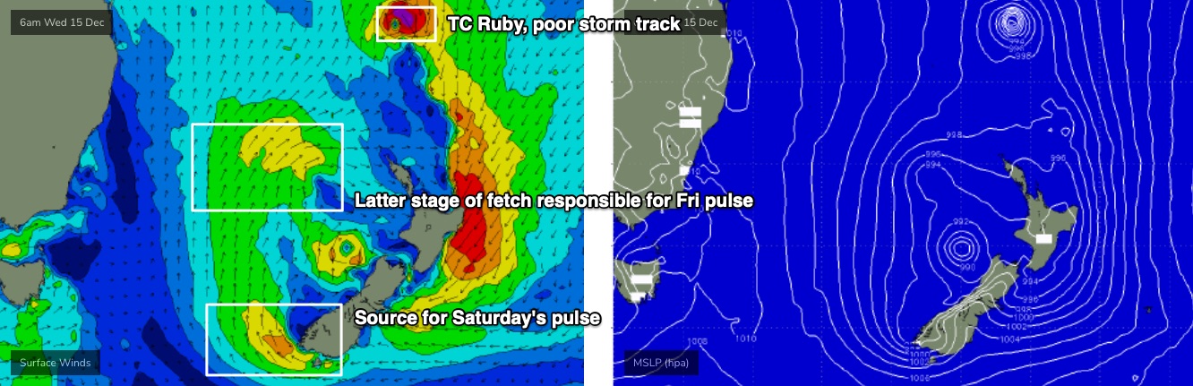
This one looks like it’ll provide good waves across Northern NSW for Saturday under a light morning breeze, with size around 2-3ft+at south facing beaches, but surf size will be smaller elsewhere and I’m not expecting much penetration into SE Qld either.
Easing surf is on tap for Sunday with freshening N’ly winds.
So, lock in Saturday morning for a surf.
Next week (Dec 20 onwards)
The Southern Ocean storm track looks out of whack for the East Coast into next week.
A powerful low pushing under Tasmania this weekend looks impressive in single synoptic snapshots, but we’ll probably just see some minor glancing long period energy at a handful of south swell magnets in Northern NSW (Mon/Tues).
Elsewhere, and later next week is showing signs of a building trade flow through the Northern Tasman Sea that should deliver some fun waves a day or so either side of Xmas. That’s certainly something to look forward to.
More on all of this in Wednesday’s forecast.
Comments
Yo Ben what does
Forecast Summary (tl;dr) - tl dr mean
tl;dr is millennial parlance for too long; didn’t read
Ah cool thanks
I'll answer for you Danosun: tl;dr = too long didn't read. Meaning, please summarise in a sentence the most important detail of the forecast as I can't be bothered reading the whole thing.
Thanks Beno
I'll stick to that as I'm usually confused by the end and go to the forecast
haha fair enough mate :)
I'll summarise.
The shit surf continues in QLD and so do the crowds!
If you're a surfer and you're considering coming here, don't!
It's more disappointing than someone steeling your Christmas tree and presents the day before Christmas!
It's more disappointing than flying to indo and the airline tells you your boards weren't loaded into the plane.
Boostered today in preparation for the southern filth influx.
Thought is was fairly tepid in the water this morning - Tweed buoy saying 24.5 C
water's been warm.
fun little stint of waves.
been some sand movement, albeit a net negative in this district.
Chrissy holiday crowds have turned up.
Water is like a warm bath.
Funny little NE swell showing this morning out at the Cap Bunkers, must have snuck through a narrow window before that low went too far south over New Cal
How big?
Not much to it maybe 2ft Max showing on a bit of NE facing Rf. Just little defined lines that weren't there yesterday
Nice obs thanks. Buoys not showing it yet but it was expected to fill in today.
That little NE swell showing on the Bundaberg buoy this afternoon
Significant amount of sand loss around here...some spots usually with a good coverage have exposed rocks I’ve never seen before. A good 2-3 metres of sand gouged out on the high tide line.
Opposite problem here.
Agree Sprout. Just north Coffs, rocks that were 1m exposed at Easter now non existent. Sand has moved from inshore to the beach causing gutters. Not great for the banks.
Miss Jane about?

Hmmm, I think the cam may be broken. Did it a few days ago but firmware upgrade isn't doing much.
Power cycle the modem?
Thanks for the tip.
that swell is hanging in nicely this morning.
Nice 2-3ft leftover S/SE swell on the Tweed this morning.
I’d call it a little bigger where I was and that wasn’t a south facing beach.
What direction was the swell?
Nice one freeride76. Swell hanging in there Ms Jane.
Was primarily S/ SE here.
Fun beachies to be had this morning with plenty of waves. the water is like a bath. The pelagics must be here.
saw an acre of tuna chopping out the back here this morning.
looked to be mack tuna.
Some small (1.5-2ft) but super clean fun ones on the SC this morning, warm as pee in the water and plenty of bait/fish/bird action out the back (& basically nobody out!!)