Average options for the short term; long term starting to look like summer

South-east Queensland and Northern NSW Surf Forecast by Ben Matson (issued Monday Dec 6th)
Forecast Summary (tl;dr)
- Easing surf for the next few days
- New E'ly swell building Thurs, holding Fri, but N'ly winds will create a few issues (there will be windows of opportunity though)
- Fresh S/SE winds all weekend, with a mix of E'ly groundswell and S'ly tending S/SE swells.. fun at outer points
- Decent SE swell holding Mon with easing winds, size then abating Tues onwards
- Long range: are the tropics about to fire up?
Recap
Small peaky surf on Saturday offered a few OK waves with sets around the 2ft+ mark at most open beaches, though freshening NE winds created bumpy conditions into the afternoon ahead of a spectacular S’ly change behind a trough, which delivered wind gusts of 75kts at Cape Byron. Fresh southerly winds into Sunday maintained below average conditions south of the border, but surf size did increase and today’s been the beneficiary with swell direction swinging more to the SE, and winds becoming lighter from the southern quadrant. Size reached 3-4ft in Northern NSW, with 2-3ft sets across exposed SE Qld venues.
This week (Dec 7 - 10)
The next few days look a little uninspiring, but there’ll be waves if you’re desperate.
Winds should become light and variable, keeping conditions generally clean, and today’s SE swell will ease back from 2-3ft to 2ft in Northern NSW on Tuesday, a little smaller in SE Qld and only suitable for the wide open beaches. Small beachies should persist at exposed spots into Wednesday thanks to a weak ridge currently stretching out across the Tasman Sea.
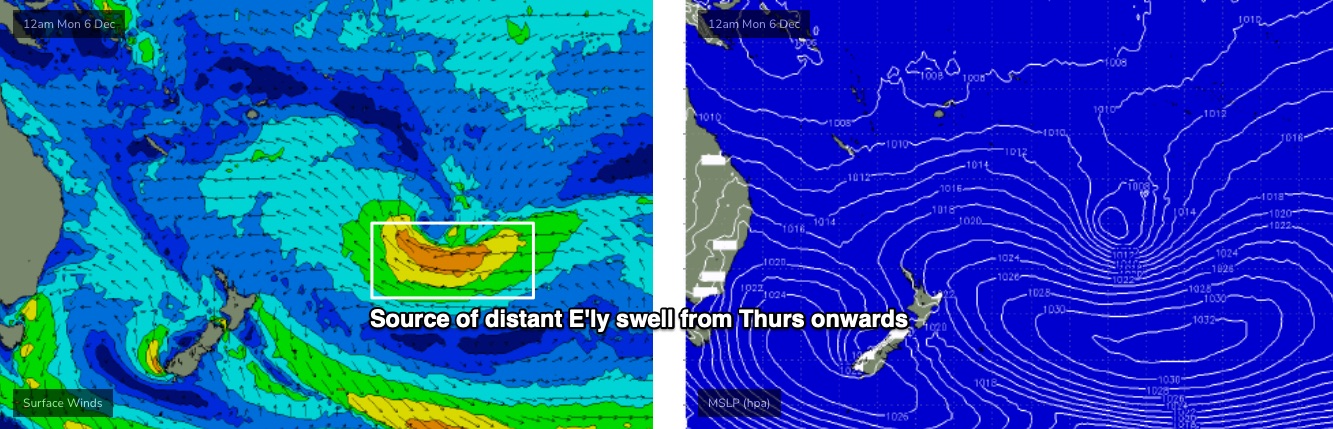
On Thursday, we’ll see a small E’ly swell make landfall, originating from a large sub-tropical low well north-east of New Zealand at the moment. We’ll see this swell fill in intermittently over the course of many days - in fact, it’s likely to peak over the weekend - but Thursday should increase size into 2-3ft+ range at most open beaches by late afternoon (smaller early) and there’ll be a noticeable increase in swell energy and consistency. Expect smaller surf running down the points. it'll be rather inconsistent though.
Thursday afternoon will see strengthening northerly winds across the Mid North Coast, as a southerly change moves up from the south. These northerlies probably won’t affect Far Northern NSW and SE Qld until Friday, and current expectations are that the change will be slow moving - so we’ll see a troughy period develop through Friday (MNC) before southerlies than push through into the afternoon, reaching north of the border overnight. There's a window of opportunity somewhere in there for everyone but I'm just not sure on the specifics right now.
But at a rough guesstimate, it looks like Thursday afternoon could be a better choice across northern regions, and Friday morning will be your best choice across southern regions.
Of course, small changes in the position of the trough could affect this outlook so check back on Wednesday.
Elsewhere, and it’ll be worth keeping a tab on a stalled trough off the Far South NSW Coast on Thursday. It’ll be outside of our swell window at this point, however a Tasman Low is expected to form on Friday, and will generate solid S’ly swells and an accompanying S’ly change for the weekend. The Lower Mid North Coast is likely to feel some of these effects on Friday afternoon, as they’ll be pushing across Southern NSW through Friday morning.
This weekend (Dec 11 - 12)
Looks like a weekend of fresh southerly quadrant winds, and a summery mix of S/SE and E’ly swells.
The subtropical low NE of New Zealand (see below) should create a secondary peak in E’ly swell with sets around the 3ft+ mark by Saturday afternoon, holding through Sunday. Wouldn't be surprised if there's the odd bigger set at a few of the swell magnets, pushing 4ft+, but this will be the exception rather than the rule. It will also be quite inconsistent thanks to the distant swell source.
The S/SE swell combo won’t be much bigger in size (wind affected 3-5ft at south swell magnets in Northern NSW on Saturday, smaller Sunday), and we’ll see swell direction out of the south on Saturday, tending S/SE on Sunday, which should allow SE Qld to also pick up some energy. However beaches will less southerly exposure will see smaller surf from this source.
Additionally, with the accompanying winds, only sheltered points and protected locations will have workable options.
Looks very much like a typical summer swell/wind mix to me.
Next week (Dec 13 onwards)
Current expectations are that the Tasman Low will persist for a little while, keeping the first half of next week flush with SE swell in the 3-4ft range across Northern NSW, smaller in SE Qld.
The weekend’s E’ly swell will however be easing by this time. Fortunately, local winds look much better as a coastal ridge relaxes, allowing the breeze to become light SW early, tending S'ly through the days.
A series of polar fronts skirting the ice shelf from this Wed/Thurs onwards will also provide a small undercurrent of southerly swell for the first half of next week too (only Northern NSW). They’re not worth worrying about.
Surf size will then gradually ease through the rest of next week, with no significant events on the radar beyond this right now.
However, there is some interesting tropical activity pegged for the Coral Sea next weekend that could lead to NE swell potential mid-late next week through next weekend and onwards.. certainly quite speculative at such long range, but worth flagging as it’s that time of the year where the tropics start to fire up.
See you Wednesday!
Comments
Hey man, I was so hopeful from last Fridays notes about this week and now I read this.
"This week (Dec 7 - 10)
The next few days look a little uninspiring, but there’ll be waves if you’re desperate."
Hey man, sorry. Just the way I see it.
Hey man I'm just happy there's something to surf aye man
Not good enough man. Not good enough! :-)
Hey man........ I've got nothing to add, I just felt like saying "Hey man".
https://www.newsroom.co.nz/the-kiwi-scientist-and-the-failed-surf-breaks...
Bit on narrowneck
The guy is clearly a con artist and this so called narrowneck reef doesn't even exist except on swellnets surfcam list. You can sometimes see a bit of a 'boil' at the southern end where there might be one bag left.
Hey man