Significant, oversized S/SE swell inbound

South-east Queensland and Northern NSW by Craig Brokensha (issued Monday 13th July)
Best Days: Experienced surfers only protected spots Wednesday through Friday, Saturday, Sunday, Monday
Recap
A fun mix of E'ly trade-swell and NE windswell for the weekend, while a new pulse of inconsistent S'ly groundswell filled in across NSW yesterday afternoon, with it holding into this morning to 2-3ft on the sets.
This week and weekend (Jul 14 - 19)
We've currently seeing the first developments regarding the significant low that's due to form in the Tasman Sea this week, with a surface trough deepening off the southern NSW coast. An upper cold pool is also sitting above the state and the trough will feed off it as the trough moves into the Tasman.
Over the coming 36 hours we’ll see the formation of a broad area of low pressure in the Tasman Sea (not classified as an East Coast Low), with it now expected to ‘bomb’ (discussed in more detail below).
Regardless of the classification, we’re set to see a significant and prolonged swell event out of the S/SE this week, easing only gradually into the weekend as the direction swings more SE.
So through this evening we’ll see a broadening fetch of strengthening E/SE winds developing on the southern flank of the low, but this will only move into our swell window early tomorrow morning.
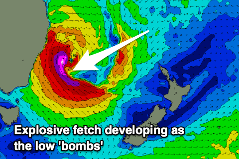 With the central pressure forecast to drop from 1014hPa to 988hPa in the 24hour period from 7pm today to tomorrow, the low will ‘bomb’ and as it does so, an explosive fetch of severe-gale to storm-force SE-S/SE winds will develop on top the growing sea state generated by the strengthening winds before it. This will occur through tomorrow, giving the Mid North Coast an upper cut into the late afternoon/evening.
A slight weakening and broadening of the low is due Wednesday but we'll still see an elongated fetch of SE gales aimed through our south-southeastern swell window with core winds likely being a touch stronger as embedded lows rotate around the main centre.
Looking at the expected trend in size, and Tuesday morning will be small with some background S'ly groundswell to 2ft or so across NSW, tiny across the Gold Coast as the E'ly swell fades.
Through the day though we'll see a rapid escalation in size as the low develops, with strengthening morning W/SW winds, giving into a strong to gale-force S/SW change. Size wise a late afternoon kick to 8ft+ is likely across the lower Mid North Coast, if not bigger on dark, while this trend will be delayed to the north and likely only building on dark, if that around Byron.
The oversized S/SE groundswell event from the core winds slingshotting up the coast is due Wednesday with the Mid North Coast likely to see maxing 12ft+ surf across exposed breaks, more to 10-12ft across the Ballina/Byron region while the Gold Coast looks to kick to 6-8ft across exposed breaks (possibly bigger cleanup), though the points will be smaller and to 4-6ft or so on the outside (smaller inside). The swell may be a touch undersized at dawn, though unlikely.
The Sunny Coast will see the swell arrive through the mid-morning and kick to 4-6ft across open beaches, much smaller inside southern corners.
Winds look favourable as the coast sits north of the lows axis with fresh to strong W/SW breezes across the Mid North Coast, moderate to fresh W-W/SW further north, shifting S/SW into the afternoon.
A slight drop in swell is expected Thursday owing to the low broadening and weakening a touch, but I can't see south swell magnets across NSW dropping below 8-10ft, especially with another local projection of S/SW gales up the coast during Wednesday. The swell looks to swing a little more south in direction, and this will see the Gold and more so Sunshine Coast dropping more noticeably in size.
Exposed breaks on the Goldy are still likely to be 6-8ft, but the points smaller and to 4-5ft on the outside, smaller inside and back to 4-5ft on the Sunshine Coast. Winds will remain favourable for southern corners with a moderate to fresh W/SW-SW breeze (lighter from Ballina north), swinging S'ly into the afternoon.
 From Friday we should start to see the size easing though still 8ft+ across NSW in the morning (smaller across the Gold Coast and Sunny Coast), owing to an upper level ridge cradling the low throughout the whole week as it slowly weakens, moving off slowly east through Saturday but more so Sunday.
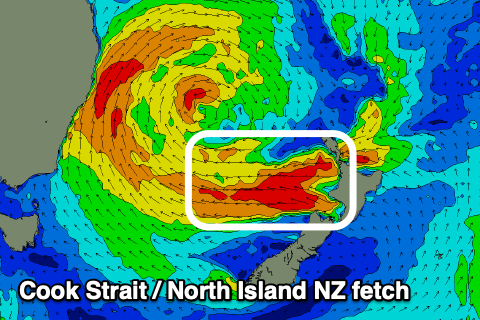
With this we'll see winds on its south-western flank weaken through Wednesday evening, while over towards New Zealand, a Cook Strait fetch of E'ly gales will develop, persisting into Thursday and Friday but dropping to strong in strength from Thursday afternoon.
A reinforcing E-SE groundswell will be seen from this source, filling in Saturday and keeping Northern NSW around 6ft to occasionally 8ft, with some mid-period S/SE energy also in the mix, 6ft+ across exposed breaks on the Goldy and 4-5ft across the outer points. An easing trend should be seen later in the day but more noticeably from Sunday as the size and period drop, with easing sets from 4-6ft across northern NSW, 4-5ft across the Goldy.
Coming back to the local winds and we'll see fresh to strong S/SW breezes Friday, tending SW across selected locations through the morning but S'ly into the afternoon, while as the low pushes east and weakens, we'll finally see lighter offshore W/SW-SW winds Saturday morning ahead of E'ly sea breezes.
Sunday will then see winds tend NW to NE favouring the more exposed beaches, which will still be solid.
More on this and any changes to the outlook on Wednesday.
Comments
I am yeti!
Damn looks like a mental week of waves to come!
Well that's going to move the banks around a bit! Buckle up.
yeah, very not sure on what this week will deliver.
big surf, yes.
but that northward moving western flank of the low is going to deliver massive amounts of near-shore windswell contamination as well as a huge amount of sea state and long-shore drift.
big sand mover, could easily wash out banks before we even start.
we'll see.
No great loss north of you Steve if current banks get washed away as they're currently shit anyway up here.
Not from where I'm sitting. Some good sand that's going to be gone in about 48 hours.
reef breaks dont wash away... well ive seen the difference when all the cunji is blasted off but thats about it
Love your descriptions Craig.......
‘giving the Mid North Coast an upper cut into the late afternoon/evening’.
big waves, big sweep. i hope this doesn't mean average storm banks.
welcome back gutter
sounds great. Waves too big to surf and horrible banks after it.
Ha, thanks Solitude, stoked with that one.
And here's a J-curve, Crowdy Head..
Love these West swells.

Ha!
Stocked up on baby food the last few days in case it’s a bank buster.
Looked like fun baby food.
had an epic solo session with my son after lunch on a ruler edged piece of sand and stray chest high sets.
no sign of any swell on dark.
maybe a few hints
Yeah as expected..
"Through the day though we'll see a rapid escalation in size as the low develops, with strengthening morning W/SW winds, giving into a strong to gale-force S/SW change. Size wise a late afternoon kick to 8ft+ is likely across the lower Mid North Coast, if not bigger on dark, while this trend will be delayed to the north and likely only building on dark, if that around Byron."
Down here a definite kick mid arvo. Did a drive by an exposed S swell magnet about 11:30 and it was 2ft. Again at 3:30 and it was a messy 4-6ft. Very S though so far...protected corners 1-2ft.
Baby food or Baby Boomer food FR?
What's going on with the models for the east swell coming through the following weekend?
SC forecast showing 7 to 9 foot, 4 days straight, is it looking likley, or too early to comment on?
Models been toying with it for a few days now.
Let's let this swell event go through first, ha.
Guarantee the coast won't be 7-9 feet for 4 days straight
I can't help myself.
There is no such thing as 7-9ft!! It's either a solid 6-8ft or 8-10ft FFS!
hahaha.
byron buoy spiking now
Gone daddy gone.
6 months of insane banks washed out overnight.
8ft of burgery, pushy S swell if you can paddle.
Yeh looks wild out there, hopefully protected spots on the high will have something, wonder if there'll be banks around when size settles down a bit
8-10ft plus bigger clean ups. Unrideable. Off to look at novelty inside corners...
Question for you swellnetters, has anyone surfed Lennox better than Fanning did during “that” swell? 2006 was it?
If so, who and when.
Maybe a seperate thread could be started, all time sessions during all time swells??
that was July 2001.
the "as good as it gets, as big as it gets" swell.
same swell as shark island challenge.
that same swell matt and i named cape solander death.
we checked it and it was biiig and pinching closing out on the end,
we warned some rock fishermen not to fish there.
went down to a bombie down the coast and on the radio they said some fishermen were washed off the cliff at cape solander. so we changed the name from farkernell to death,
no one knew about it back then.
Not sure what the rules are on posting links to another forecast site, however Google this if anyone is interested in reading about that swell. Were you amongst it FR? Would love to have been able to have watched this in real time or better yet travel back in time:
THIS DAY IN SURFING: JULY 8TH, 2001
Ahhh 'the swell'. I could talk about that for hours. Scored on the Cenny Coast. Mind melting.
Yeah, the images all up and down the coast, It looks as close to perfection as one can get. Bet those memories will last your entire lifetime BD
Cheers for that link suggestion Benno. Was epic to go back. I clearly remember how mesmerising the ocean looked....how out of place these giant clean lines looked on the everyday coast. Scored the Haven, Copa Pt and Nth Shelly at the peak of the swell...nearly drowned (by my pissweak efforts at the time) at Nth Shelly. Talking to Shane Powell during that sesh and he'd surfed Nth Avoca that morning and likened it to Teahupoo.... keeping in mind he'd had a near death event at Chopes not long before, pretty significant call. Hope you have a few epic memories from it too mate.
Gee, Shane's comments definitely add weight to what went down hey, not that anymore justification was needed haha, Great stuff BD. Mate I wish I was a party to it, back in 01' I was in boarding school up in Brisbane probably 13 at the time. The history of epic swells and the stories of crew out amongst it, really lights up the imagination!!
Longest closeouts I've seen in a while. Couldn't see either end of a few. No-one out and not because it's big. Should have gone around the corner but couldn't be arsed with the walk. Mint day though, whales playing around.
Solid up the north end of the Goldy..
How's the sand.. Good size but devil wind..
yep, devil wind will render unrideable for most of this swell.
devil winds, closeouts and banks gone. another hyped south swell.
Hyped in your mind? Expectations have to be set for such conditions and where to or where you won't be able to surf.
Freeze frames are always deceiving
wtf is going on with this north wind on southern gc? west winds i can handle, but this is such a ruiner
Will improve from here.
Vic plated cars getting shat on in Byron area?
Vic sorely needs country plates like WA has had for a long time, eg .BE - shire of Beverley; GNG - Geraldton Greenough; .GN - Gnowangerup; MR - Margaret River, from memory.
Could have MP - Mornington Peninsula; SC - Surfcoast; MY - Moyne; CG - Corangamite; AL - Alpine Shire etc
AU is Margs region.
Was pumping where I was on the sc this morning. Big crowd and slow but good when they came
Well played FreeRide, not quite the burgers!
yeah, no fucking need to rat it out.
can't it wait until the swell is over Craig?
I've deleted but he's sent that out to 10's of thousands and there's insta vids all over the web..
yeah, I know.
there were a million cunts with cameras.
still, thanks.
was a lot more fun than it looked first thing this morning.
Gold Coast afternoon report is below average. Not once did the devil winds change at the beach, i stood watching burleigh for 3 hours, and now its light onshore. but its reported that the winds have swung SW. I noticed the wind change at Coolangatta airport around 11am, however that didnt reflect the beach conditions.
One glance at the cams would have confirmed it.
Yeah bummer, totally against hi-res model guidance as well which is usually spot on. Cleaner days to come..
Fingers crossed, was so hard sitting there watching knowing if that wind swung slightly the waves would have been pumping. Hopefully the next couple of days.
Was supposed to be 8-12ft on south facing beaches today but i dont think it got anywhere near that!!
I reckon it did, easily. Not anymore though.
Yeah good here, but would love to be in the Ments at present, my good friend that runs 3 charter boats emailed me today:
"Gday PJ, been non stop pumping for nearly a week, big barrels. Extending the trip a week, so epic and pumping. Put 6 stitches in a chin, broken boards, pulled another surf charter off the reef, had one guy say best waves of his life today, best day of his life he said. Heading to moots for this next couple of pumping south swells. Incredible swells, back to back to back to back."
Morning session with super consistent sets and undergunned crowd. Loved seeing the ocean move around again . Gonna love the next five days . Feeling super grateful
Swell definitely organised itself better as the day went on...raw and out of control in the early morn...quick novelty corner session mid morn and better than expected post lunch bombie session...tomorrow should be good.
yeah it got real good on the first hour of the incoming tide push here.
died in the arse on the late arvo high tide.
see what tomorrow brings, but there was definitely a lot less energy in the ocean through the mid to late arvo.
Would say def probably in between that first surge. Swell didn't back off all day here until real late and in saying that, that was because of the tide. Size still there.