Strong S/SE swell for the weekend

South-east Queensland and Northern NSW Surf Forecast by Craig Brokensha (issued Friday 11th October)
Best Days: Saturday morning, protected spots Sunday, early Monday, south swell magnets Tuesday
Recap
Plenty of swell but not the greatest conditions on offer yesterday, while a stronger pulse of S/SE groundswell due today arrived late in the day across the Mid North Coast. This swell arrived earlier than expected in southern NSW and has peaked this morning across most locations, instead of this afternoon as expected.
Locations south of Byron have been between 3-5ft with good conditions, a little more powerful on the Gold Coast but still on the small side.
This weekend and next week (Oct 12 - 18)
These notes will be brief as Ben’s on annual leave.
We've got a temporary low point in swell tomorrow, ahead of a large and slightly upgraded S/SE groundswell event that will likely be seen across the Mid North Coast before dark, but peak Sunday across all locations.
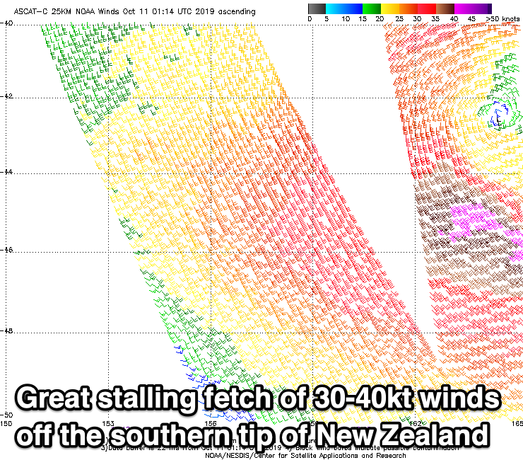
Yesterday's and today's pulse of S/SE groundswell was generated as the Tasman Low which formed off the NSW coast Tuesday evening, strengthened south-east of us Wednesday.
The low since weakened a touch and drifted south-east towards New Zealand, and is sitting just west of the South Island, aiming a slightly stronger that forecast fetch of gale-force SE winds towards the southern NSW coast.
The low reached a peak in intensity yesterday afternoon and evening, and satellite observations picked up a nice pass of the low (below). This will result in a large S/SE groundswell spreading out towards us.
Tomorrow will likely be around 3-4ft+ across most south swell magnets in NSW, with the Gold and Sunny Coasts small and back to 1-2ft.
The new S/SE groundswell should kick to an easy 6ft by dark across the MNC Saturday, with Sunday seeing 5-6ft sets across most south swell magnets in northern NSW, with bigger 8ft sneakers across MNC swell magnets.
SE Qld should see the swell arrive through the morning, if not there at dawn and coming in at 2-3ft across open beaches, with the odd bigger one across swell magnets.
Looking at the local winds and we should see more variable breezes tomorrow morning, though the lower MNC looks possibly onshore, with onshore winds developing across all locations through the day from the eastern quadrant.
Sunday should see S/SW winds early across all locations, fresh to strong S/SE into the afternoon, favouring protected spots
Monday morning is expected to see plenty of size owing to the longevity of the fetch off the South Island with easing sets from 4-5ft+, down from 3-4ft across south swell magnets Tuesday morning.
Winds will swing to the north though, early N/NW-NW on the MNC Monday morning, better and W/NW across the far North Coast before gusty N/NE breezes kick in, N/NW tending N/NE across all locations Tuesday.
As the swell fades further mid-week a small NE windswell signal is expected, while we should also see a fun pulse of E/SE swell Thursday/Friday from a fetch of strong to gale-force E/SE winds exiting New Zealand's Cook Strait Monday evening and early Tuesday.
More on this Monday though. Have a great weekend!